Grand Central Terminal Ramp, New York City

The ramp to the lower concourse at Grand Central Terminal, around 1913-1920. Image courtesy of the Library of Congress, Detroit Publishing Company Collection.

936_1913-1920 loc

The same location in 2016:

936_2016
New York’s Grand Central Terminal is the world’s largest train station in terms of number of platforms, and in order to save space in crowded midtown Manhattan, it was built with two levels of tracks. The first photo was taken shortly after the station opened in 1913, showing the ramp to the lower platforms. At the time, the Main Concourse, located just on the other side of the columns on the left, served inter-city passengers, while the lower tracks were for suburban commuter trains.

By the mid-1900s, passenger travel had significantly declined, and the station was subject to a major alteration that would have destroyed most of the original interior. However, it survived and was subsequently restored, and today the only real difference in these two photos is the appearance of the walkway above the ramp. Amtrak no longer uses the station, though, so today all of the platforms on both the upper and lower levels are used by Metro-North Railroad commuter trains.

Lost New England Goes West: Ferry Building, San Francisco

Author’s note: Although the main focus of this blog is New England and the northeast, I sometimes include photos from other parts of the country. This is the first in a series of then and now photos of California that I took this past winter.

The San Francisco Ferry Building in the aftermath of the April 18, 1906 earthquake. Image courtesy of the Library of Congress, Detroit Publishing Company Collection.

867_1906c loc

The Ferry Building in 2015:

867_2015
San Francisco is not an island, but for most transportation purposes it might as well be. Except for those traveling from the south, any approach to the city requires crossing either the San Francisco Bay on the eastern side of the city, or Golden Gate to the north. Prior to the construction of these bridges in the 1930s, the only way to do this was by ferry, and as a result this building was once among the busiest ferry terminals in the world.

The ferry terminal was built at the foot of Market Street along the present-day Embarcadero, and opened in 1898. Just a few years later, its durability was put to the test by the disastrous April 18, 1906 earthquake that, along with the resulting fires, destroyed much of the city. The first photo was probably taken only days after the earthquake, and it shows that, in contrast to the rubble and charred telephones in the foreground, the building survived with minimal damage. Interestingly, the first photo shows a makeshift barbershop on the far right side amidst the debris. The hand-written message on the side of the tent reads “Shaving 15¢” and, in smaller lettering, almost as an afterthought, is “Hair Cut 25¢.”

In the years following the earthquake, the terminal continued to be a vital part of the city’s transportation system until the completion of the Bay Bridge in 1936 and the Golden Gate Bridge the following year. Some ferries continued to operate out of here, but much of the interior was altered as passenger traffic declined. Another major change came in the 1950s, when the Embarcadero Freeway was built through here. Much like the Central Artery in Boston, this elevated highway cut off the city from the waterfront, and the ferry terminal was largely isolated.

The building survived another major earthquake in 1989, but the Embarcadero Freeway did not. It was heavily damaged in the earthquake, and was demolished in 1991 and replaced with light rail tracks that are visible in the distance of the second photo. At the same time, restoration work also began on the ferry terminal. Today, some ferries still depart from here, but the historic building is also used for office space and as a marketplace, and a year-round farmers’ market is held in front of the building three times a week.

USS Detroit at Boston Navy Yard

The cruiser USS Detroit in Dry Dock 2 at Boston Navy Yard, on December 16, 1928. Image courtesy of the Boston Public Library, Leslie Jones Collection.

835_1923-1934c bpl

The scene in 2015:

835_2015
Taken about 23 years after the photo in the previous post, this view of Dry Dock 2 shows the USS Detroit (CL-8), an Omaha-class light cruiser, undergoing work at the Boston Navy Yard. The Detroit had been built in nearby Quincy, Massachusetts, and was commissioned in 1923. Several years after the first photo was taken, she was transferred to the Pacific, and was based out of San Diego before being moved to Pearl Harbor in 1941. She was present during the attack on Pearl Harbor on December 7, and survived the battle without any damage, and went on to see extensive service in World War II, including being present in Tokyo Bay for the surrender in 1945. Following the war, though, the Detroit was sold for scrap in 1946, along with many other obsolete surplus ships.

The Boston Navy Yard, as mentioned in the previous post, closed in 1974, and part of it was taken over by the National Park Service. Today, many of the historic buildings and other structures have been preserved, including Dry Dock 2 and some of the buildings in the distance. One of the most distinctive buildings in the yard is the octagonal Muster House, which can be seen just to the left of the ship. It was built in the 1850s, and it is still standing today, partially hidden by trees in the distance. The long building in the center of the photo has also been preserved and repurposed; it is now the MGH Institute of Health Professions.

USS Maryland at Boston Navy Yard

The cruiser USS Maryland in Dry Dock 2 at the Boston Navy Yard, around 1905. Image courtesy of the Library of Congress, Detroit Publishing Company Collection.

834_1905c loc

The scene in 2015:

834_2015
The first photo shows Dry Dock 2 at the Boston Navy Yard, which was completed in 1905, not long before the first photo was taken. It was part of a large expansion of the facility, and it supplemented the much older and smaller Dry Dock 1. At 750 feet long, it could accommodate the Navy’s newest ships, including the Maryland, a Pennsylvania-class armored cruiser that, like the dry dock, was completed in 1905.

In the years after the photo was taken, the Maryland was eventually renamed the Frederick to free up the name for a new battleship, and the ship served in World War I. Like many other early 20th century American warships, though, the ship’s service history was brief. She was decommissioned in 1922, and sold for scrap in 1930.

As for the Boston Navy Yard, it remained in use throughout World War I, World War II, and beyond. It was finally closed in 1974, and part of it was taken over by the National Park Service as part of the Boston National Historical Park. Dry Dock 2 is just outside the park limits, but it is still intact, including the pump house, the small round building directly in the center of the 2015 photo. Just to the left of the pump house is Flagship Wharf, one of several modern condominium complexes that have been built on parts of the former navy yard.

For another scene of Dry Dock 2 in use, see the historic photo in this post, taken in 1929.

Scollay Square, Boston

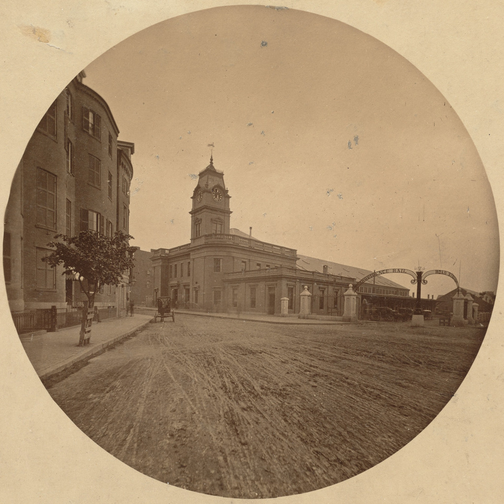
Scollay Square, looking north from the corner of Tremont and Court Streets, sometime in the 1860s. Image courtesy of the Boston Public Library.

823_1860-1869c bpl

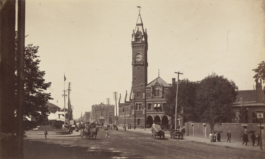
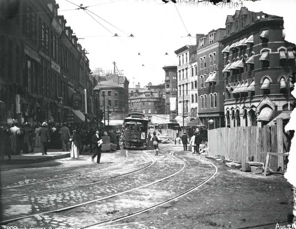
Scollay Square on August 26, 1897. Image courtesy of the City of Boston Archives.

823_1897_08_26 coba

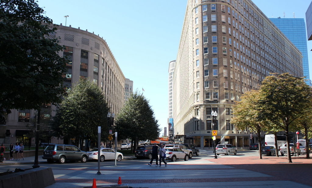
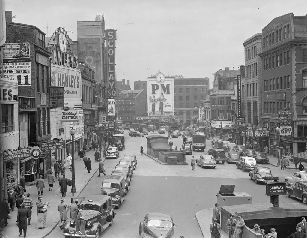
Scollay Square around 1942. Image courtesy of the Boston Public Library, Leslie Jones Collection.
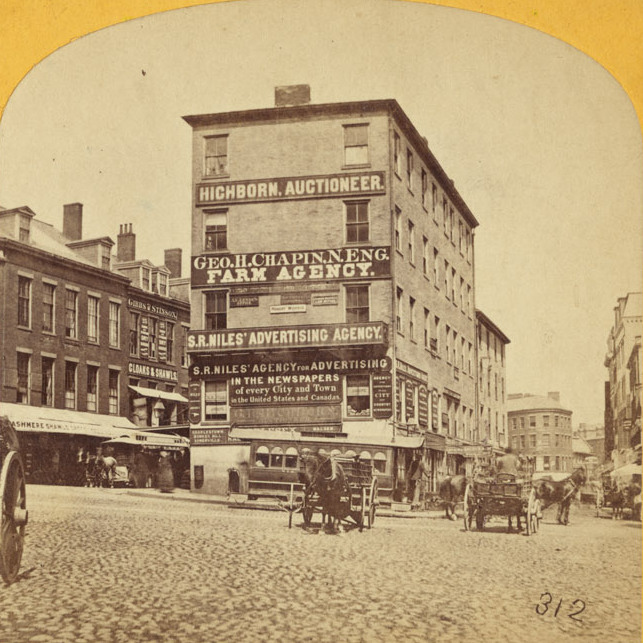
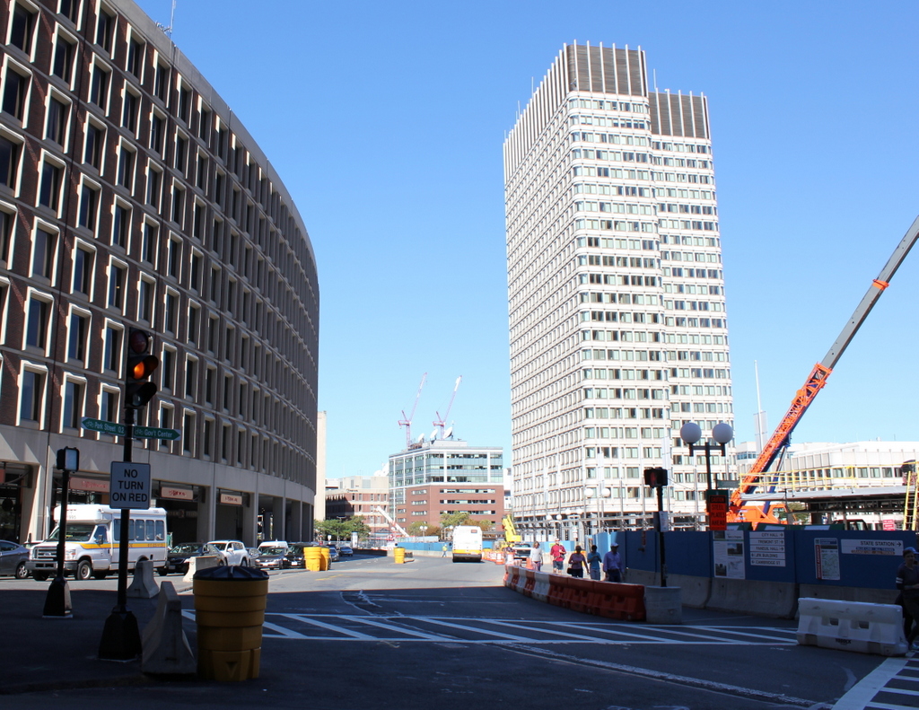
823_1942c bpl

The scene in 2015:

823_2015
These four photos reveal the dramatic transformations that have occurred at Boston’s Scollay Square over the past 150 years. The square once included a long, narrow row of buildings in the middle, which appear on city maps as early as the 1720s. The construction date for the building in the first photo is unknown, but it was once at the southern end of this row, and in 1795 it was purchased by William Scollay, a real estate developer for whom the square would eventually be named. By the time the first photo was taken, all of the other buildings in the middle of the square had been demolished, and Scollay’s building was taken down soon after, around 1870.

The second photo shows a very different scene. Some of the buildings along the square are still standing, but the Scollay Building is gone, as are the horse-drawn trolleys from the first photo. Instead, they have been replaced by electric trolleys, like the one shown in the photo. However, these would not last long, at least not on the surface. The second photo was taken only about a week before the Tremont Street Subway opened, and the photo shows some of the construction activity as the workers prepared the Scollay Square station for its opening day on September 3. The station itself is not visible, but its ornate entrance can be seen in this post, which shows the scene from a slightly different angle.

Scollay Square had long been a major commercial center in the city, but by the time the third photo was taken in the 1940s, it had seen a dramatic decline. Many of the old buildings were still standing, but the businesses had become seedier. The 1942 photo shows a number of bars, liquor stores, cheap restaurants, and burlesque theaters, and the area was particularly popular among sailors on leave from the Boston Navy Yard and college students from the many nearby schools. One prominent hotel and theater in both the second and third photos was the Crawford House on the far right. It was built in 1865 and underwent several renovations, including one in 1926 that completely altered the front. The building burned in 1948, and all but the first two floors were demolished a few years later.

By the 1950s, the area was being targeted for urban renewal. Looking to replace the area with something more respectable, the Boston Redevelopment Authority demolished over a thousand buildings in the vicinity to build the Government Center complex, which includes the Center Plaza to the left, the John F. Kennedy Federal Building in the center, and the Boston City Hall, just out of view to the right. The old Scollay Square subway station was also extensively renovated and renamed Government Center. When the last photo was taken, the station was undergoing a another renovation, so if there is one thing that the second and fourth photos have in common, it is subway station construction.

Boston and Providence Depot, Boston

The Boston and Providence Depot at Park Square in Boston, around 1860. Image courtesy of the Boston Public Library.

815_1860c bpl

The station around 1885. Image courtesy of the Boston Public Library.

815_1885c bpl

The scene in 2015:

815_2015

The Boston and Providence Railroad opened in 1835, at a time when Boston was still a peninsula connected to the mainland by a narrow isthmus. To avoid taking up scarce land, the railroad built a long trestle across the Back Bay, which at the time was a tidal marsh between Boston and Roxbury. The railroad terminal was built here at the edge of the water, at what eventually became Park Square.

The original station from the first photograph was demolished in the early 1870s so that the city could build Columbus Avenue, and it was replaced with the much larger station in the second photograph. In advertisements, it was hailed as “The Palace Depot of the World,” and from here passengers could board a train for Providence, New York, and other points south. However, by the late 19th century there were eight different railroads serving Boston, each of which operated its own separate station. The four railroads on the north side all had terminals near where North Station would be be built in 1893, and three of the south side terminals were located in the immediate vicinity of today’s South Station. The Providence and Worcester depot was the one outlier; it was on the south side, but it was a half mile away from the next closest station.

Because the multiple stations were both inconvenient for passengers and a waste of valuable property, the four south side railroads finally consolidated into South Station in 1899. This station and the tracks leading to it were closed, and the railroad, which by then had been leased to the New York, New Haven and Hartford, was rerouted onto new tracks, parallel to the Boston & Albany Railroad.

Today, none of the buildings from the first two photos are still standing. The site of the station is now the Boston Park Plaza Hotel, which was built in 1927 as the Hotel Statler Boston in the triangular block between Columbus Avenue, Park Plaza, and Arlington Street. The only visible remnant from the first photo is the Emancipation Memorial statue, which was added to Park Square in 1879 and can be seen on the far left of both photos.