Lost New England Goes West: Dupont Street, San Francisco

Looking north on Dupont Street (now Grant Avenue) in San Francisco, sometime in the 1850s. Image courtesy of the Library of Congress, Historic American Buildings Survey Collection.

898_1850-1860c loc

Grant Avenue in 2015:

898_2015
This street has been at the heart of San Francisco’s Chinatown neighborhood since the first photo was taken over 150 years ago. Originally named Dupont Street, it soon became a red light district, notorious for its opium dens, brothels, and gang violence. In the background of the first photo is Old Saint Mary’s Cathedral, which opened in 1854 and, as a warning to would-be patrons of the neighborhood, has an inscription below the clock that reads, “Son, Observe the Time and Fly from Evil.”

The 1906 earthquake destroyed the entire street along with the rest of Chinatown, leaving only the burned-out shell of the church still standing from this scene. The disaster gave the city the opportunity to clean up the seedy establishments in the area, and to reflect this change the street was even renamed, to Grant Avenue. The buildings in the foreground of the 2015 scene were probably built in the immediate aftermath of the earthquake, and the old church is partially visible in the distance. The street is still a popular destination in San Francisco, though not for the same reasons in the 19th century; instead of brothels and opium dens, Grant Avenue of today is lined with Chinese restaurants and shops that sell gifts, souvenirs, and jewelry.

Lost New England Goes West: Old Saint Mary’s Cathedral, San Francisco

Old Saint Mary’s Cathedral at the corner of California Street and Grant Avenue in San Francisco, around 1856. Image courtesy of the DeGolyer Library, Southern Methodist University.

897_1856c smu

The church around 1866. Image courtesy of the Library of Congress, Lawrence & Houseworth Collection.

897_1866c loc

The church in 2015:

897_2015
As mentioned in earlier posts, San Francisco of the 1850s was very different from just a decade earlier. When gold was discovered in California in 1848, its population was just a thousand, but by the early 1850s it had jumped to over 30,000, and was rapidly growing. To accommodate the number of Catholics, the city’s first cathedral was built here in 1854, and the building has stood here ever since. At the time, it was located near the fringes of the city, near Chinatown and some of the notorious red light districts, which explains the “Son, Observe the Time and Fly from Evil” inscription just below the clock.

The first photo was taken before the steeple was completed, but by the early 1860s the church looked essentially the same as it does today. It served as the cathedral for the Archdiocese of San Francisco until 1891, and since then it has been a parish church. In 1906, it was one of the few buildings in the area to survive the earthquake, which did no serious structural damage to it. However, the earthquake started fires that gutted the building, so today the only original part of the church is the brick exterior.

The surrounding Chinatown neighborhood was rebuilt after the fires, and today it is home to the largest Chinese population in the world outside of Asia. This section of Grant Avenue in particular is a major tourist attraction, and Old Saint Mary’s Cathedral remains both an active church and also a major landmark that dates back to the city’s early years as a Gold Rush town.

This post is part of a series of photos that I took in California this past winter. Click here to see the other posts in the “Lost New England Goes West” series.

Lost New England Goes West: Portsmouth Square, San Francisco

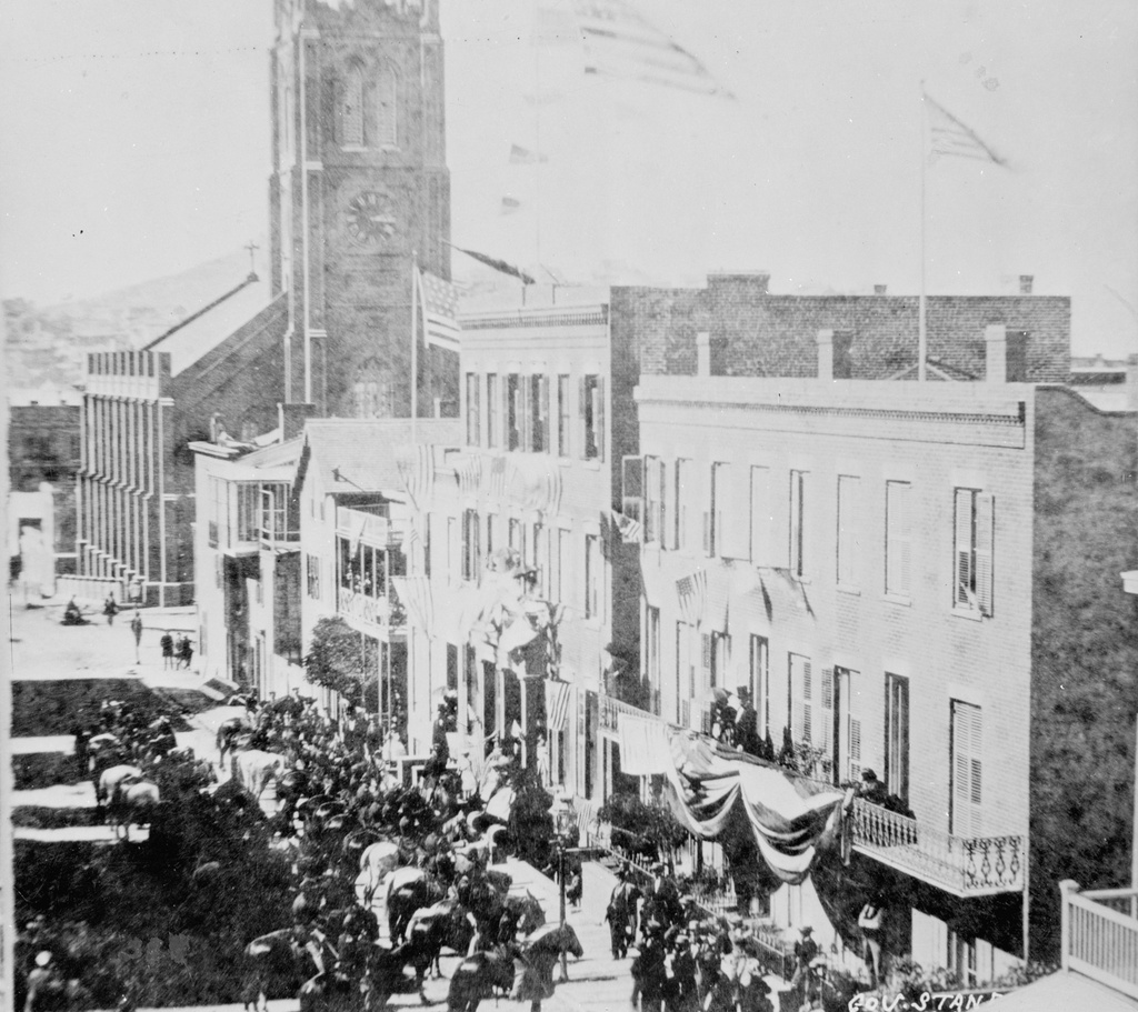
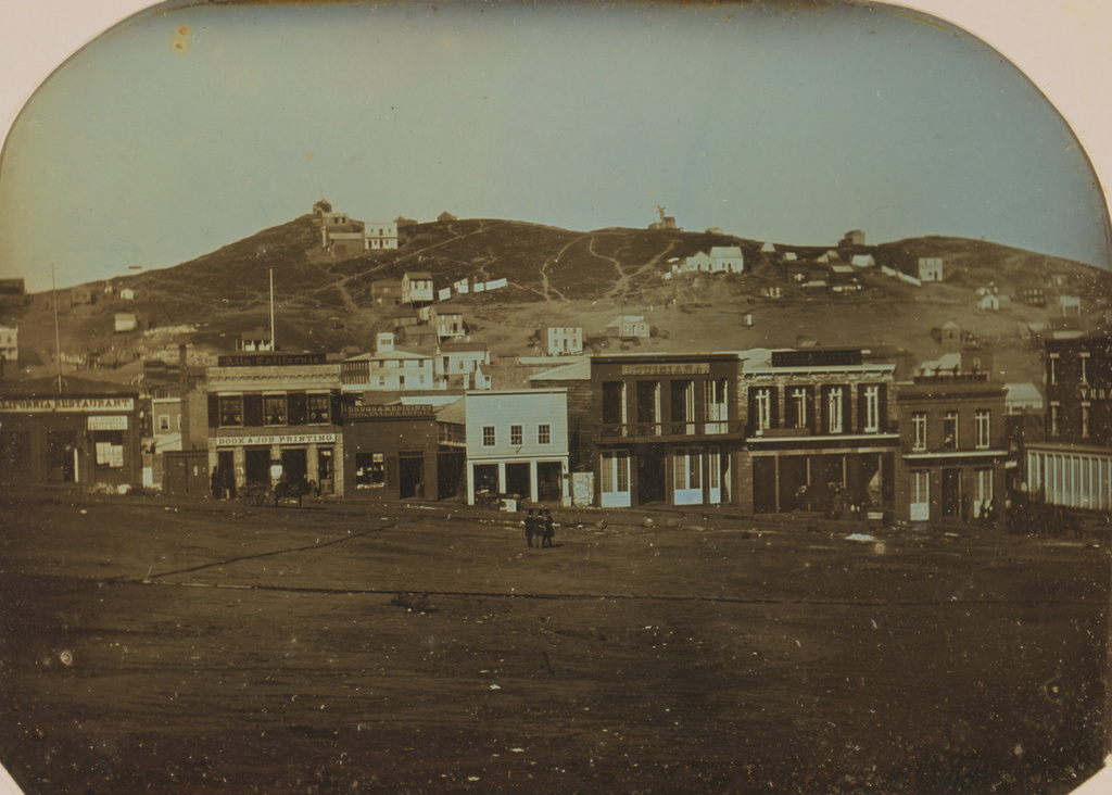
The view of Portsmouth Square in San Francisco, with Telegraph Hill in the distance, in January 1851. Image courtesy of the Library of Congress, Daguerreotypes Collection.

883_1851-01 loc

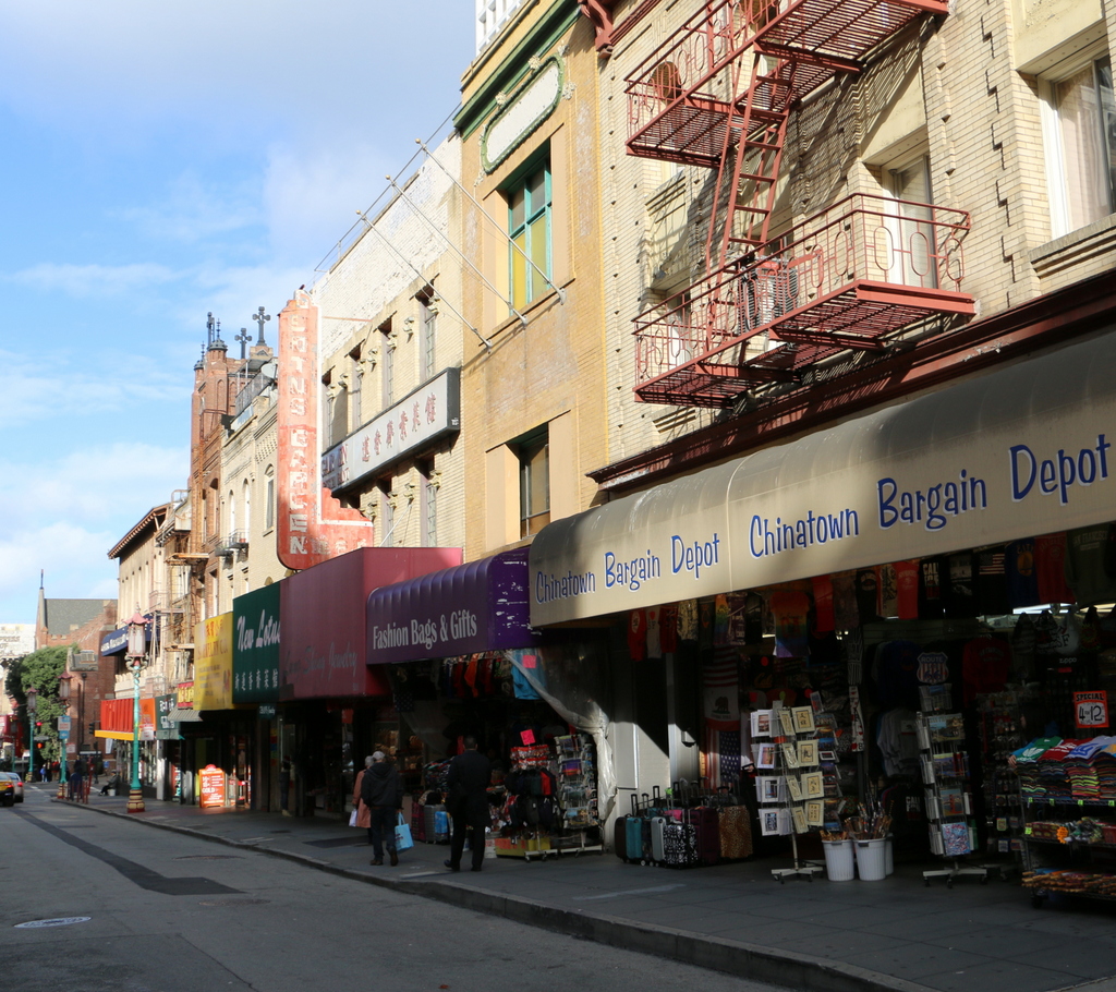
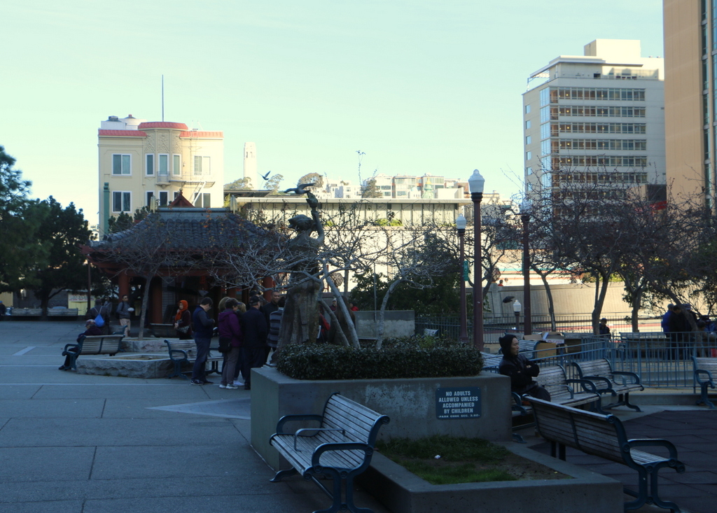
Portsmouth Square in 2015:

883_2015
When the first photo was taken in January 1851, San Francisco was in the middle of a massive population boom spurred by the California Gold Rush. Just a few years earlier, it had been a small Mexican village of several hundred inhabitants, and was named Yerba Buena. In 1846, during the Mexican-American War, the USS Portsmouth arrived to claim the settlement for the United States, and the sailors raised an American flag here at what is now called Portsmouth Square. The following year, Yerba Buena was renamed San Francisco, and in 1848 California officially became part of the United States.

At the time, there were about a thousand residents in San Francisco, but this figure grew exponentially as gold seekers poured into the city from around the world. Portsmouth Square was at the center of much of this activity, and the foreground of the 1851 scene shows a variety of businesses here. On the far left is the California Restaurant, and next to it is the Alta California, a newspaper that, about 15 years later, employed a young journalist with the pen name of Mark Twain. Further to the right are some of the seedier elements of the city, reflective of its “wild west” days during the Gold Rush. The three buildings to the right were, from left to right, the Louisiana, the Bella Union, and the Sociedad, all of which were saloons and gambling houses that sought to liberate the newly-wealthy gold miners of their money.

In the distance of the first photo is Telegraph Hill, one of the city’s many hills. It was still sparsely populated when the first photo was taken, but at the top of the hill is a semaphore station that had been built in 1849. This semaphore telegraph, as it was known as, had a tower with arms that could be raised or lowered to visually communicate messages, giving the hill its name. From here, the operator could view ships passing through Golden Gate and could signal information to the city about its port of origin, cargo, and any important news.

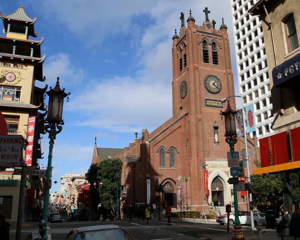
Today, nothing is left from the original photo. Anything that was still standing 55 years later would have been destroyed in the 1906 earthquake, when fires swept across much of the city, including Portsmouth Square and parts of Telegraph Hill. Portsmouth Square is now a public park at the center of San Francisco’s Chinatown neighborhood, as seen in the foreground of the 2015 photo. In the distance, Telegraph Hill is mostly hidden from view, but some of the buildings are visible, including the Coit Tower, which was built in 1933 on the site of the old semaphore telegraph.

This post is part of a series of photos that I took in California this past winter. Click here to see the other posts in the “Lost New England Goes West” series.

Franklin Street, Boston (3)

Looking west on Franklin Street from Devonshire Street in Boston, sometime in the late 1850s. Image courtesy of the Boston Public Library.

818_1857c bpl

Franklin Street in 2015:

818_2015
This view of Franklin Street shows the former Tontine Crescent section of the street from the opposite direction of the photos in these posts here and here. When this area was developed by architect Charles Bulfinch in the 1790s, it was an upscale residential neighborhood. Just a few years before the first photo was taken, this curve was lined with elegant townhouses, but by the late 1850s nothing remained of Bulfinch’s design except for a few trees in the middle of the street and the curve of the street itself.

The new commercial buildings in the first photo represented Boston’s growth and development as a prominent city, but they would turn out to be short-lived. Just over a decade later, the entire area was destroyed in the Great Boston Fire of 1872. They were rebuilt within the next year or so with similar-looking buildings, and many are still standing today. The 2015 photo shows a number of these 1870s buildings, although the background is dominated by Boston’s newest skyscraper, the Millennium Tower, which was under construction in the first photo and is scheduled to be completed in the summer of 2016.

New South Church, Boston

New South Church at the corner of Summer and Bedford Streets in Boston, around 1855-1868. Image courtesy of the Boston Public Library.

817_1855-1868c bpl

The scene in 2015:

817_2015
Not to be confused with the Old South Meeting House, or the New Old South Church, this church at the corner of Summer and Bedford Streets was known as the New South Church. It was octagonal in shape and made of granite, and it was designed by Charles Bulfinch, a prominent early American architect who designed a number of buildings in Boston, including the Massachusetts State House, the expanded Faneuil Hall, and Boylston Market.

When the church was completed in 1814, this neighborhood in the present-day financial district was an upscale residential area. A few block away on Franklin Street was Bulfinch’s famous Tontine Crescent, and here on Summer Street there were also a number of high-end townhouses. Daniel Webster lived in a house at the corner of Summer and High Street, just a few steps back from where these photos were taken, and although he died before the first photo was taken, this would have essentially been the view he would have seen whenever he left his house.

By the 1860s, though, Boston was running out of land, and this area was eyed for redevelopment. Most of the townhouses were taken down as the neighborhood shifted from residential to commercial, and in 1868 the New South Church was also demolished and replaced with a bank. The new building didn’t last long, though; it was destroyed in the Great Boston Fire of 1872, and the present-day Church Green Building was completed the following year. Although the historic church is long gone, its eventual replacement has become historic in its own right. Despite being in the heart of the Financial District, it has survived for nearly 150 years, and it is now listed on the National Register of Historic Places.

Maryland Heights from Harpers Ferry, West Virginia

Looking across the Potomac River toward Maryland from Harpers Ferry, around 1859. Image courtesy of the Library of Congress, Civil War Collection.

729_1859c loc

The scene in 2015:

729_2015 loc
Assuming the estimated date is correct, the first photo was probably taken within a few months before or after John Brown’s raid on the Harpers Ferry Armory.  It shows the view from the Armory looking across the Potomac River toward Maryland Heights, with the Baltimore & Ohio Railroad bridge to the right.  The Chesapeake & Ohio Canal also ran through this scene; the buildings across the river were built on either side of Lock 33.

Within a few years, much of this scene would change.  Harpers Ferry changed hands many times during the war, and during one of their retreats the Confederate forces burned the bridge, as seen in the 1861 photo in the previous post, which was taken from the opposite side of the river.  The bridge has since been replaced several times, and the current one can be seen on the far right, a little upstream of the original one.

The Chesapeake & Ohio Canal survived the war, and despite increased competition from railroads it remained in operation until 1924.  Today, the stone remains of Lock 33 are still standing, hidden from this view by the railroad bridge and the trees along the river.  All of the buildings have long since disappeared, though, except for one: the two story stone house right up against the cliff on the left side of the photo.  It was built in the winter of 1840-1841, and survived John Brown’s raid, the Civil War, and a number of floods before being gutted by a fire in the 1960s. The stone walls are still standing, though, and it is now part of the Harpers Ferry National Historical Park.

One historical curiosity in the second photo is the advertisement painted on the rocks near the center of the photo.  It reads “Mennen’s Borated Talcum Toilet Powder,” and it was painted in 1906 for railroad passengers as they traveled through here.  Although not as distinct as it once was, the controversial advertisement is still there, despite efforts in the 1960s to remove it using paint remover and carbon black.