Union Station, Albany, New York

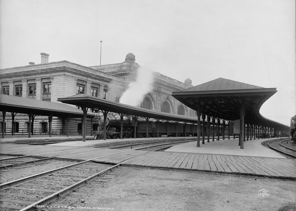
The platforms on the east side of Union Station in Albany, around 1904. Image courtesy of the Library of Congress, Detroit Publishing Company Collection.
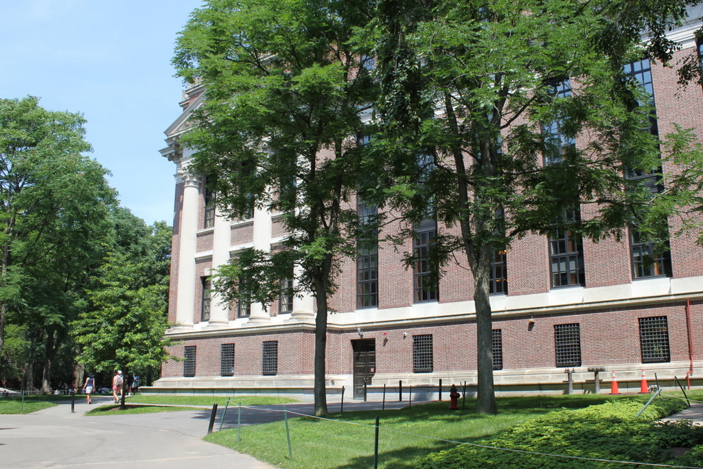
The scene in 2019:

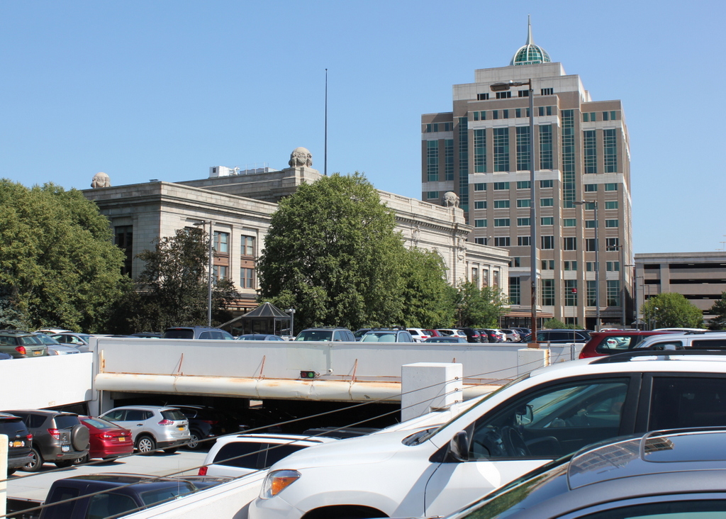
Taken nearly 120 years apart, these two photos capture one of the ways in which transportation changed in the United States over the course of the 20th century. The first photo shows a large, recently-completed downtown railroad station, with several trains waiting on the tracks and a group of people on one of the platforms. However, in the present-day scene the railroad station has been converted into offices, while the tracks and platforms are completely gone, replaced with a parking garage. Another even larger parking garage stands in the distance on the right side, and further to the right, just out of view, is an interstate highway.

Albany’s Union Station was completed in 1900, and it was primarily used by the New York Central and Hudson River Railroad. However, it was also used by the Delaware and Hudson Railway and the New York Central-controlled West Shore Railroad, and it was the western terminus of the Boston and Albany Railroad, which the New York Central had begin leasing earlier in 1900. The station building featured a granite, Beaux-Arts exterior, and it was designed by the prominent Boston architectural firm of Shepley, Rutan and Coolidge. This firm was particularly well-known for their railroad stations, and they designed a number of them for the Boston and Albany, including Union Station in Springfield and South Station in Boston.

The station was built at the corner of Columbia Street and Broadway, with the main entrance on the western side, facing Broadway. However, this view shows the other side of the station, looking north from the southern end of the platforms. Here, three large island platforms were situated between the tracks, and passengers could access them via two underground tunnels. The train on the left side of the first photo is a New York Central passenger train, with 4-4-0 locomotive number 1135 in the lead. Another unidentified locomotive stands on the far right side of the photo, and further in the distance just to the left of that train is a group of men—possibly railroad employees—leaning against and sitting on a row of baggage carts. These trains were just two of the 96 daily trains that served Union Station when it first opened at the turn of the 20th century. Of these, there were 42 New York Central trains, 31 Delaware and Hudson, 13 West Shore, and 10 Boston and Albany.

Passenger rail travel continued to increase nationwide throughout the first half of the 20th century, eventually peaking during World War II. This was also the busiest time for passenger trains in Albany, with 121 daily trains here at Union Station. However, the postwar period saw a sharp decline in ridership, a problem exacerbated by the development of the Interstate Highway System starting in the 1950s. By the 1960s, many of the railroad companies that had dominated the nation’s economy a half century earlier were now teetering on the brink of bankruptcy. As a result, the New York Central merged with its longtime rival, the Pennsylvania Railroad, in 1968, forming the Penn Central Railroad.

For nearly a decade prior to the merger, the New York Central had been looking to rid itself of Albany’s Union Station, which was under-utilized and expensive to maintain. The station was also near the path of the planned Interstate 787, which would cut through part of the station’s passenger yard. Soon after the formation of Penn Central, the newly-formed railroad opened a new, much smaller passenger station directly across the river from here in Rensselaer, and the old Albany station was unceremoniously closed on December 29, 1968.

A few months later, the New York Times published an “obituary” of the station, titled “In Melancholy Memory of Albany’s Union Depot.” The article lamented the closure of the grand station, recalling its long history during the heyday of passenger trains and contrasting its architecture with that of the new station, which was described as a “one-story crackerbox of concrete blocks.” At the time, the fate of the old station was still undetermined, but the article mentioned several different proposals, which ranged from converting it into a museum to demolishing it and building a high-rise luxury apartment building and marina on the site.

Ultimately, neither of these proposals materialized, and the building was instead converted into offices in the 1980s. It was originally the home of Norstar Bancorp, and it was initially named Norstar Plaza, although it was subsequently renamed Peter D. Kiernan Plaza after the death of the bank’s president. The bank then went through a series of mergers, and over the next two decades the building was home to Fleet Financial Group, FleetBoston Financial, and then Bank of America. The building was used by Bank of America until 2009, and it now serves as offices for several other companies.

Overall, the present-day scene is drastically different from the view in the early 20th century. The most dramatic change is the parking garage in place of the station tracks and platforms, but other changes have included the tall building just beyond the station on the other side of Columbia Street. However, the station itself has not seen many exterior changes since the first photo was taken, even though much of it is hidden by trees from this angle. Today it stands as an excellent work of Beaux-Arts architecture, and it also serves to highlight the benefits of historic preservation and adaptive reuse.

John Hodges House, Salem, Mass

The house at 81 Essex Street, at the corner of Orange Street in Salem, around 1890-1914. Image courtesy of the Phillips Library at the Peabody Essex Museum, Frank Cousins Collection of Glass Plate Negatives.

The house in 2019:

The second half of the 18th century was a time of great prosperity for Salem because of its thriving maritime trade, and many of the town’s wealthy captains and merchants built fine houses such as this one. This house was built around 1750 by John Hodges, a ship captain who was about 26 years old at the time. Hodges had purchased this property a year earlier, the same year that he married Mary Manning. The couple subsequently raised eleven children here, four of whom died young. Of the surviving sons, five went on to become captains themselves, although two of them died at sea.

Their third child, Benjamin, became one of Salem’s leading captains in the late 18th century. He was a cousin of Elias Hasket Derby, one of the richest merchants in New England, and he frequently commanded Derby’s ships, including the Grand Turk and the Astrea, which were among the first American ships to trade with the far east. Later in his career, Benjamin Hodges was involved in the construction of the frigate USS Essex, the largest ship—and only warship—ever built in Salem. It was funded by subscription from residents of Salem, including Hodges, who also served on the building committee, and it was presented to the United States Navy in 1799. Also in 1799, Hodges was one of the founders of the East India Marine Society, which has since become the Peabody Essex Museum. He then became the organization’s first president, serving until his death in 1806.

Benjamin Hodges acquired this house from his father in 1788, and he lived here with his wife Hannah and their large family. Tragically, though, most of their children died young from tuberculosis, starting with an infant daughter in 1783. Their oldest child, Hannah, died of it in 1792 at the age of 13, followed by ten-year-old John in 1797, 12-year-old Margaret in 1803, 19-year-old Benjamin in 1804, and 14-year-old Sarah in 1812. Both parents also succumbed to the disease, with Benjamin dying in 1806 at the age of 52, and Hannah in 1814 at the age of 59. Only three of their children lived relatively long lives, and only one, Mary, married and had children.

Mary Hodges married William Silsbee in 1808, and the couple lived here in this house, possibly with Mary’s unmarried sisters Hannah and Elizabeth. Like Mary, William was also from a prominent Salem family. His older brother Nathaniel was a ship captain and merchant who later went on to have a successful political career, serving four years in the U. S. House of Representatives and nine years in the Senate. William was likewise a merchant, with ownership interests in a number of vessels. He and Mary had seven children, and he lived in Salem until his death in 1833 at the age of 53. Four years later, Mary and her sisters sold this house, and she died in 1851 at the age of 62.

The house was subsequently owned by Stephen Webb, the cashier of the Mercantile Bank in Salem. He is not to be confused with his contemporary, Stephen Palfrey Webb, whose unusual political career involved serving as mayor of Salem from 1842 to 1845, mayor of San Francisco from 1854 to 1855, and then mayor of Salem again from 1860 to 1862. The Stephen Webb who lived here was about 34 years old when he purchased the house in 1837, and he was still living here during the 1850 census, along with his wife Martha, their five children, and two Irish-born servants. The same census valued his real estate—which may have included more than just this house—at $8,100, equivalent to about $250,000 today.

Stephen Webb had apparently died by 1870, because that year Martha—who was identified on the deed as a widow—sold the house for $3,750 to Sarah Maria Benson, the widow of Captain Samuel Benson. She died two years later, and the 1872 city directory shows her son, George Wiggin Benson, living here. At the time, his household included his ten-year-old son Frank Weston Benson, who later went on to become a prominent Impressionist painter. The future artist would live in Salem for much of his life, but was apparently only in this house for a short time, because by the 1874 city directory his father had moved to a house on Forrester Street.

During the late 19th century the house was owned by Henry Meek, who served as city clerk and later owned a publishing company. He was 54 years old in the 1900 census, and he lived here with his wife Annie, his daughter Alice, and a servant. This was apparently Henry’s second marriage, since Annie was only five years older than his 24-year-old daughter. He died later in 1900, and in 1906 Annie and Alice sold this house to Emma J. Brady.

The first photo was likely taken at some point during or shortly after the Meek family’s ownership. It was taken by Frank Cousins, a Salem native and noted photographer who used his camera to document hundreds of historic buildings in Salem and elsewhere in the northeast. The exterior of the house appears to have been well-preserved at the time, and it would have provided Cousins with a good example of colonial-era Georgian architecture.

Unlike the previous owners, Emma Brady does not appear to have lived here in this house, and instead used it as a rental property. The 1910 census shows that, at the time, it was being rented by Charles M. Proctor, a 44-year-old meat salesman who lived here with his wife Mary, their children Harrison, Charles, Arthur, Clifford, Mildred, and Gladys, and Harrison’s wife Nina. Like his father, Harrison worked as a meat salesman, while Charles was a winder at an electric works and Arthur was a farm laborer.

By the 1920 census the house had changed hands again, and at this point it was being used as a four-family home. There were a total of 11 people listed here that year, four of whom were immigrants, with three from Quebec and one from Greece. Aside from two children, all of the residents were employed, including three leather workers, two cotton mill workers, two machinists, a cook, and a rooming house keeper.

Overall, this house saw a steady decline in the prosperity of its residents, as shown by the fact that the former home of one of Salem’s most prominent captains had become a four-family apartment building. This was a common occurrence throughout Salem during this period; it had peaked in its importance as a seaport at the turn of the 19th century, when it ranked among the top ten most populous cities and towns in the country. However, Salem’s shipping industry was badly hurt by both the Embargo Act of 1807 and the War of 1812, and its merchants never fully recovered. This led to a long period of economic stagnation, and the city saw only moderate population growth during the second half of the 19th century.

From a historic preservation standpoint, though, this was not entirely a bad thing. The lack of economic or population growth led to little demand for new construction, resulting in the survival of many historic buildings. Today, one of Salem’s most visible assets is its large number of well-preserved late 18th and early 19th century homes, including the John Hodges House here on Essex Street. Although it has undergone many changes in ownership and use over the past quarter of a millennium, it stands as a reminder of the city’s historic maritime past, with few significant differences from its appearance more than a century ago when the first photo was taken. It is now one of the contributing properties in the Salem Common Historic District, which was added to the National Register of Historic Places in 1976.

Connecticut River and Mount Tom from Mount Holyoke, Hadley, Mass

The view looking south from the Mount Holyoke Summit House in Hadley, around 1900. Image courtesy of the Library of Congress, Detroit Publishing Company Collection.

The scene in 2019

One of the most important geological features in the Connecticut River Valley is the Metacomet Ridge, a long narrow traprock formation that runs roughly parallel to the river. It passes through central Connecticut and western Massachusetts, running from Long Island Sound to just south of the Vermont border. Its peaks are relatively low in elevation compared to the mountains of the Berkshires further west, with few reaching above a thousand feet, but the ridge stands out in the landscape because it rises so high above the surrounding low-lying river valley.

Because of this prominence, the Metacomet Ridge offers expansive views from atop its steep traprock ledges. However, perhaps none of these views are as celebrated as those from Mount Holyoke, which sits on the border of Hadley and South Hadley, Massachusetts. The 935-foot mountain is in the middle of a ten mile section that features some of the highest elevations of the entire ridgeline. This section is bookended by the two highest peaks of the Metacomet Ridge, with the 1,200-foot Mount Tom at the southern end and the 1,106-foot Mount Norwottuck to the east.

Although Mount Holyoke is comparatively lower in elevation, it has a unique position. Here, the ridge takes a sharp 90-degree turn across the Connecticut River, forming two perpendicular ranges bisected by the river. Mount Holyoke is located directly east of the river, so the top of the mountain provides dramatic views of the river as it winds its way through the surrounding farmland. Most famously, these scenes inspired 19th century artist Thomas Cole to paint The Oxbow, one of the most iconic landscape paintings in the history of American art.

The view captured in The Oxbow is not the same direction as the two photos shown here in this post. Cole’s painting faces almost due west, while these two photos were taken facing south, looking downstream on the river with the city of Holyoke in the distance on the left and Mount Holyoke on the right. Unlike the views to the west or north from the summit, this southern view is not nearly as celebrated in paintings or photographs. Part of this might be because the viewer is typically facing into the sun in this direction, creating a backlit scene. Another reason might be because the mountain has a much more gradual southern slope, so the landscape seems more distant when compared to the views from atop the steep northern and western cliffs.

Either way, the scene in the first photo shows some interesting contrasts. The jagged spine of the Metacomet Ridge runs across the horizon of the photo, parallel to the gently curving Connecticut River in the center of the scene. Further to the left, the prosperous industrial city of Holyoke in the distance contrasts with the open fields and scattered farmhouses of the foreground. The view is somewhat different in the present-day scene, as the trees now obscure most of the foreground, but both the river and the ridgeline remain dominant features in the landscape.

Both of these photos were taken from the porch of the Summit House, which was built in 1851 and expanded several times in the second half of the 19th century. At the time, mountaintop resorts were particularly popular, and the Summit House here on Mount Holyoke was just one of three in the vicinity; the others included the Eyrie House atop Mount Nonotuck, and the Summit House on Mount Tom, which is visible in the distance on the right side of the first photo.

It is difficult to tell, but the Mount Tom building in the photo appears to have been the first of three successive ones at the summit. This one burned in 1900, probably soon after the photo was taken, and it was subsequently rebuilt twice in the early 20th century. The Eyrie House likewise burned in 1901 and was never rebuilt, yet the Mount Holyoke hotel has managed to avoid such a fate, and the building is still standing today as a museum.

More than a century after the first photo was taken, and nearly two centuries after Thomas Cole made the mountain famous, much has changed in the view from Mount Holyoke. The land is actually far more forested now than it was at the turn of the 20th century, so in some ways there are actually fewer obvious signs of human development. However, the abundance of trees also makes very clear the swath that Interstate 91 cuts across the modern-day landscape, about halfway between the river and the mountains.

Despite these changes, though, the view from Mount Holyoke remains perhaps the most impressive landscape view in southern New England. Although overnight guests no longer stay at the Summit House, the mountain remains a popular destination, with visitors driving up the auto road or climbing the relatively short hike from the base. In 1939, the summit and the surrounding land became the Joseph Allen Skinner State Park, after its namesake donated the land to the state. Much of the remaining land along the Holyoke and Mount Tom ranges has similarly been preserved, and the area affords some of the best hiking and other outdoor recreation opportunities in the Connecticut River Valley.

Thomas Crane Public Library, Quincy, Mass

The Thomas Crane Public Library on Washington Street in Quincy, around 1900-1906. Image courtesy of the Library of Congress, Detroit Publishing Company Collection.

The library in 2019:

The Thomas Crane Public Library was established in 1880 by Albert Crane as a memorial to his late father, Thomas Crane. Born in 1803, Thomas grew up in Quincy and began working here as a stonecutter in the granite quarries. He later moved to New York, where he had a successful business career selling Quincy granite in the rapidly-growing city. However, he did not forget Quincy, often spending his summers here, and after his death in 1875 his son decided that a public library would be an appropriate way of honoring his memory.

The building was designed by Henry H. Richardson, one of the nation’s preeminent architects of the 19th century. Richardson pioneered a style known as Richardsonian Romanesque, which typically featured rounded arches, tall narrow windows, and rough exterior walls with contrasting light and dark stone. The vast majority of Richardson’s works were public buildings, including a number of churches and railroad stations, and he also designed several libraries. Despite its relatively small size, this library is generally regarded as one of his finest works, with architectural historian and Richardson biographer Henry-Russell Hitchcock declaring it to be “without question the best library Richardson ever built.”

The library was completed in 1882, with the formal dedication on May 30. Albert Crane and other members of his family attended the event, and he ceremonially handed over the keys of the building to Charles Francis Adams Jr., the grandson and great grandson of Quincy’s two famous presidents. Adams then gave the keynote address, in which he recounted the life of Thomas Crane, with a particular emphasis on his humble origins and his strong personal character and morals.

The building’s architecture was well received, and the Boston Journal published a glowing review of its design as part of its coverage of the dedication ceremony:

It is built in what may be termed free Romanesque style of architecture, and is in the form of a parallelogram, 84 by 41 feet in dimensions. The outer material is of Easton pink-tinted granite trimmed with Longmeadow brown stone. The interior above the basement is occupied by one lofty story and a low studded attic. The southern portion is devoted to a reading room. There are in the large hall 16 alcoves with a capacity of 40,000 volumes, and a small room is specially devoted to books and manuscripts pertaining to local history. The effect of the interior is pleasing. There are seven large windows beautifully decorated in stained glass by La Farge. In the east window of the reading room are the suggestive words; “And his leaves shall not wither.” The principal light is a remarkable piece of work, the design of which is by La Farge, and represents in vivid hues an old philosopher holding a roll in his hand. The finish of the interior is of Southern pine, beautifully decorated. The cost of the structure was $40,000, and the expense of grading and embellishing the grounds will probably reach $10,000 or $15,000 additional.

Despite the large capacity of the original library building, though, it was soon in need of expansion. The first addition came in 1908, with a wing in the rear of the library. Richardson had died more than 20 years earlier, but one of his former employees, William Martin Aiken, designed the addition, which matched the appearance of the original building. A second, more substantial expansion came in 1939, with the construction of a new building immediately to the southeast, connected to the older building by an L-enclosed walkway that is partially visible on the far right side of the present-day scene. As with Aiken’s wing, the architecture of this addition copied Richardson’s style. Then, the last expansion occurred in 2001, with a substantial addition to the east of the 1939 wing that doubled the size of the library.

Today, despite these many additions, the original 1882 Richardson portion of the library has remained essentially unchanged from this view. Its surroundings have changed, and the tower of the 1927 Bethany Congregational Church now looms above the building in the distance, but the old library has survived as an important work by one of the greatest architects in American history. Because of its architectural significance, the library was added to the National Register of Historic Places in 1972, and 15 years later it was designated as a National Historic Landmark, the highest level of federal recognition for a historic property.

Gore Hall, Cambridge, Mass

Gore Hall at Harvard University in Cambridge, around 1905. Image courtesy of the Library of Congress.

The scene in 2019:

Gore Hall was constructed between 1838 and 1841 as the first purpose-built library building on the Harvard campus. The Gothic Revival-style exterior was constructed of Quincy granite, and it was designed by noted architect Richard Bond, who drew inspiration from King’s College Chapel at Cambridge University. The building was named for Christopher Gore, a 1776 Harvard graduate who went on to serve as a U. S. senator and governor of Massachusetts. He died in 1827 and left a substantial amount of money to the school, some of which was used to build this library.

Upon completion, the new library housed about 41,000 books, and the size of the building seemed adequate for future growth of its collections. However, within about 50 years the library had outgrown this space. A new addition was constructed on the east side of the original structure in 1877, and it is visible in the distance on the right side of the first photo. This expanded the building’s capacity by about 250,000 books, but even this was not enough, and in 1895 the ornate interior was largely gutted to add space for another quarter million books.

The first photo was taken around the turn of the 20th century, not long after this renovation took place. The library would be expanded one more time in 1907, but by this point its days were numbered. The building’s demise was ultimately hastened by, of all things, the sinking of the Titanic in 1912. Among the passengers lost in the disaster was businessman George Dunton Widener and his son, 27-year-old Harvard graduate Harry Elkins Widener. Harry’s mother, Eleanor Elkins Widener, survived the sinking, an she subsequently donated money to Harvard in order to construct a new library in memory of her son.

Gore Hall was ultimately demolished in 1913, in order to make room for the Harry Elkins Widener Memorial Library, which was completed in 1915. This building is still standing here today, where it serves as the main library of Harvard University. In this scene, there are no visible remnants from the first photo, although some parts of Gore Hall were repurposed or preserved. The granite blocks of the old building were used for the foundations of the Widener steps, and several of the ornate pinnacles still survive, including two here at Harvard.

Memorial Hall, Cambridge, Mass

Memorial Hall on the campus of Harvard University in Cambridge, around 1904. Image courtesy of the Library of Congress, Detroit Publishing Company Collection.

The building in 2019:

Harvard’s Memorial Hall was built between 1870 and 1878, in honor of the Harvard students and graduates who had fought for the Union cause during the Civil War. Its construction was primarily funded by an alumni committee that raised $370,000 in contributions, in addition to a separate bequest of $40,000 from 1802 graduate Charles Sanders for the construction of a theater. As a result, the building featured three distinct parts: a large dining hall on one side, the Sanders Theatre on the other side, and the Memorial Transept between them.

The building was designed by Harvard graduates William Robert Ware and Henry Van Brunt, and it is generally regarded as an architectural masterpiece and one of the country’s finest examples of High Victorian Gothic architecture. This style reached its peak of popularity in the late 1860s and early 1870s, when it was nearly ubiquitous for schools, churches, government buildings, and other public buildings. Memorial Hall incorporates many of the typical features of this style, including tall windows with pointed arches, steep roofs with multi-colored tiles, a tall tower, and a red brick exterior with contrasting light-colored stone trim.

Construction began in 1870, and it was marked by the laying of the cornerstone on October 6. Many dignitaries attended the event, including Governor William Claflin, Senators Charles Sumner and Henry Wilson, and General George Meade, who had led the Union victory at Gettysburg seven years earlier. U. S. Attorney General Ebenezer Hoar, a Massachusetts native and Harvard alumnus, gave the dedication address, and the ceremony also included the singing of a hymn written for the occasion by Oliver Wendell Holmes Sr.

The various parts of the building were completed in different stages, and both the dining hall and the Memorial Transept were finished in 1874. The dining hall occupies the majority of the building, including everything to the left of the tower from this scene. It measured 164 feet in length, 60 feet in width, and 80 feet from the floor to the top of the roof. The hall had room for over a thousand people to sit at the tables, although the actual number of Harvard students who ate here in the late 19th century was generally much lower, with around 450 to 650 students in any given year.

The Memorial Transept is located just to the right of the dining hall, inside the main entrance on the right side of this scene. It spans the entire width of Memorial Hall, separating the dining hall from the theater, and it has a similar entrance on the other side of the building. Inside, the transept measures 112 feet in length in 30 feet in width, and it features marble tablets on the walls, which contain the names of 136 Harvard students and alumni who died in the war. Only Union soldiers are recognized here; many Harvard graduates also died fighting for the Confederacy, but their names are not included in the transept.

On the other side of the transept, and barely visible from this angle, is the Sanders Theatre, which was completed in 1875. Originally it could seat 1,500 people, and it was used as a venue for commencement exercises, along with a number of other events, including concerts and lectures. The theater continued to be used for commencements until 1922, and during this time perhaps the most famous graduate here was Theodore Roosevelt, of the class of 1880. Many years later, he would return here as a guest speaker in the same theater, and over the years other notable speakers have included Winston Churchill and Martin Luther King Jr.

From the exterior, the most distinctive feature of Memorial Hall is its 200-foot tower. However, this has been altered and rebuilt several times, beginning in 1877 when the original architects made some changes to its original appearance. Then, in 1897 a clock was added to the top of the tower, with one face on each of the four sides. The first photo was taken soon after this, and the building retained this appearance until 1956, when the upper portion of the tower was destroyed in a fire.

In the meantime, the use of Memorial Hall also changed in the 20th century. The dining hall closed in 1926, and for the next 70 years this space was used for a wide variety of events, ranging from banquets to blood drives. Then, in the 1990s this space underwent an extensive renovation, and it was restored to its original use as a dining hall. It was renamed Annenberg Hall in 1996, and since then it has been used as the primary dining hall for Harvard freshmen.

Along with the interior work, the exterior of the building was also restored in the 1990s, most notably with the reconstruction of the top of the tower. The top had been missing ever since the 1956 fire, but it was rebuilt in 1999, using the designs from the 1877 work on the tower. As a result, the exterior of Memorial Hall probably more closely resembles its 19th century appearance today than it did when the first photo was taken in the early 1900s.

Other than the changes to the tower, the only significant difference between these two photos is Cambridge Street in the foreground. In the first photo it was an unpaved street with several trolley tracks running down the middle, but in the 1960s it was lowered to build a long underpass, with a pedestrian mall atop it. This allowed direct access from Harvard Yard to the sections of the campus north of Cambridge Street, although it also had the consequence of significantly changing the streetscape here in front of Memorial Hall.