Armory at Harpers Ferry, West Virginia

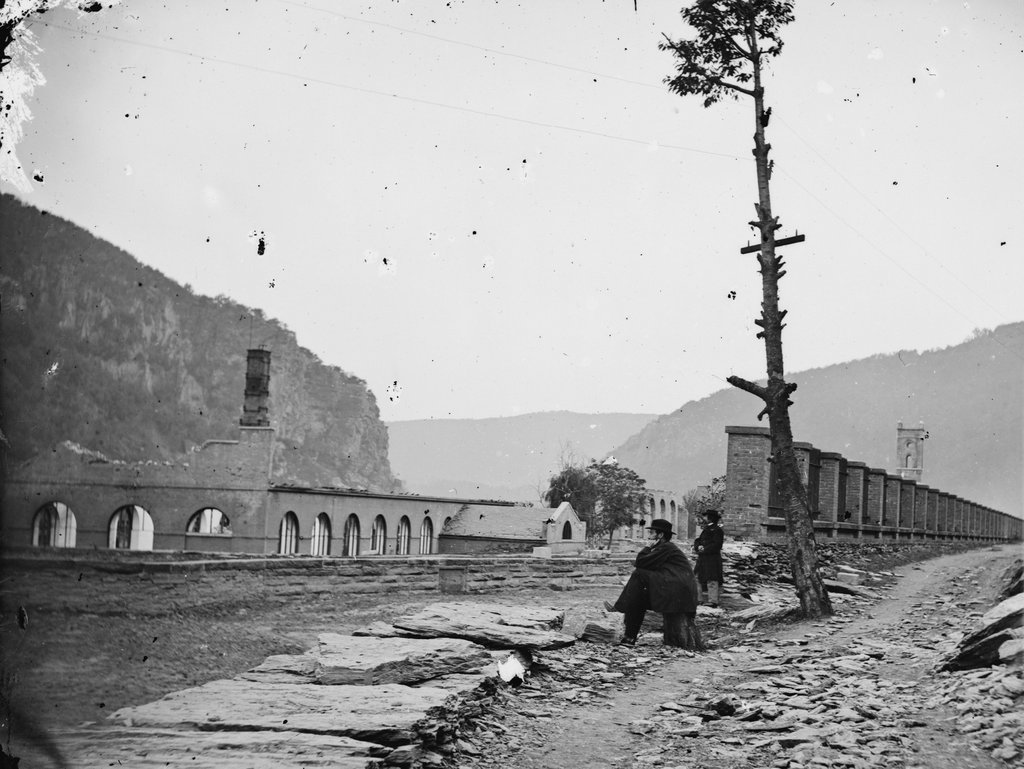
The ruins of the Harpers Ferry Armory, photographed in October 1862. Image courtesy of the Library of Congress, Civil War Collection.

730_1862-10 loc

The scene in 2015:

730_2015 loc
Prior to the Civil War, Harpers Ferry was the location of one of the country’s two federal armories, with the other being in Springfield, Massachusetts.  Both sites were chosen by George Washington, and they had similar advantages.  Harpers Ferry and Springfield are both located on major rivers at the intersection of major transportation routes, but they are also located above the head of navigation on their respective rivers, preventing a naval attack from a foreign enemy.

In the first half of the 19th century, these two armories developed new ways to manufacture firearms, using machinery that mass-produced identical, interchangeable parts and that could be operated by unskilled workers.  By the start of the Civil War, there were over 15,000 guns stored here, which helped entice John Brown to lead a raiding party in 1859.  His goal was to start a slave rebellion by taking the arsenal and distributing the weapons to area slaves, and although the plan failed, it helped to spark the Civil War only a year and a half later.

By the time the first photo had been taken in October 1862, Harpers Ferry had already changed hands a number of times in the Civil War, and armies on both sides had steadily destroyed the buildings in order to prevent the other side from making use of them.  The ruins seen here are from the same building that can be seen on the right hand side of the 1861 photo in this post.

Around the time that the first photo was taken, the ruins had several notable visitors, including Abraham Lincoln, who toured the armory site in October, perhaps on the same day that the photo was taken.  Author Nathaniel Hawthorne also visited Harpers Ferry earlier in 1862, and wrote the following description in his essay “Chiefly About War Matters”:

Immediately on the shore of the Potomac, and extending back towards the town, lay the dismal ruins of the United States arsenal and armory, consisting of piles of broken bricks and a waste of shapeless demolition, amid which we saw gun-barrels in heaps of hundreds together. They were the relics of conflagration, bent with the heat of fire, and rusted with the wintry rain to which they had since been exposed. The brightest sunshine could not have made the scene cheerful, nor have taken away from the gloom from the dilapidated town; for, besides the natural shabbiness, and decayed, unthrifty look of a Virginian village, it has an inexpressible forlorness resulting from the devastations of war and its occupation by both armies alternately.

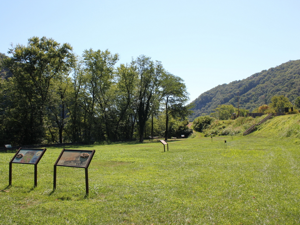
The town became part of West Virginia in 1863, and things were relatively stable here until the end of the war.  However, at that point the damage had been done.  The pre-war economy of Harpers Ferry had relied almost exclusively on the armory, but it was never rebuilt following the war.  The land was sold, and the Baltimore & Ohio built railroad tracks through part of the land, including the present-day railroad station, which was completed in 1889. Today, this area is part of the Harpers Ferry National Historical Park, and although there are no buildings still standing here from the armory, the interpretive signs help to give visitors an idea of what was once here.

Division 16 Police Station, Boston

The Division 16 Police Station on Boylston Street, just west of Hereford Street, around 1914. Image courtesy of the City of Boston Archives.

701_1914c coba

The buildings in 2015:

701_2015
When the first photo was taken, this police station on Boylston Street consisted of the larger building in the background and the small one-story building in the center.  The larger building is attached to the Ladder 15/Engine 33 Firehouse, and it was completed in the mid-1880s.  At some point in the early 20th century, the police station added the small building to the left of it, and the two buildings were used by the Boston Police Department until 1976.

Today, neither building has seen drastic changes in appearance.  They narrowly survived the construction of the Massachusetts Turnpike, which was completed in 1965 and runs directly under the spot where the photo was taken.  From 1976 to 2007, the larger building was the Institute of Contemporary Art, and it is now owned by the Boston Architectural College.  The smaller building has since been converted into a restaurant, and as of 2015 it is Dillon’s Restaurant and Bar, which is named after a police captain who was stationed here from 1920 to 1950.

Old City Hall, Boston

Johnson Hall, which served as a courthouse and later as City Hall, on School Street around 1855-1862. Image courtesy of the Boston Public Library.

691_1855-1862c bpl

Boston’s old City Hall, which replaced Johnson Hall, as seen in 1865. Image courtesy of the Boston Public Library.

691_1865 bpl

Old City Hall in 2015:

691_2015
This site on School Street has had two different City Hall buildings, as seen in the photos above, but the history here goes back even further.  From 1704 to 1748, Boston Latin School was located here, and during this time many of the Founding Fathers attended the school, including Benjamin Franklin, John Hancock, Samuel Adams, and Robert Treat Paine.  Years later, Charles Bulfinch designed a courthouse that was built here in 1810; this building, which is shown in the first photo, was used as both a county and federal courthouse in the early 19th century.  From 1841 until 1862, it was Boston’s City Hall, before being demolished and replaced with a newer, larger building.

The new City Hall was completed in 1865, and was one of the first examples of Second Empire architecture in the United States.  This French-inspired style would become very popular in the late 1860s and 1870s, especially in government buildings.  Boston’s old post office, which was built a decade later and just a few blocks away, shares many similar features.  On a much larger scale, the Old Executive Building next to the White House in Washington, DC also reflects the influence of Second Empire designs.

During its time as City Hall, this building saw the rapid growth in the city during the late 1800s and early 1900s.  When it was completed, the city had fewer than 200,000 people, but by the 1950s there were over 800,000, and the city government had long since outgrown this building.  The City Hall Annex, located behind this building on Court Street, was built in 1912 to accommodate more offices, but by the 1960s the city was looking to build a new City Hall.  The current building was completed in 1968, and since then the old building has been extensively renovated on the inside for commercial uses, but the exterior is essentially unchanged from 150 years ago.

Post Office, Boston

The old post office at Post Office Square in Boston, around 1906-1920. Image courtesy of the Library of Congress, Detroit Publishing Company Collection.

690_1900-1920c loc

The scene in 2015:

690_2015
The triangular intersection of Congress, Pearl, and Milk Streets has been known as Post Office Square since 1874, with the completion of the post office seen in the first photo. The square was actually the result of the Great Boston Fire of 1872, which destroyed most of the buildings around the post office, which was under construction at the time.  The small park is still there, although most of the buildings around it have changed.

The old post office was demolished to build the John W. McCormack Post Office and Courthouse, which was completed in 1933 and is still standing today.  It features Art Deco architecture, and at 22 stories and 600,000 square feet it is substantially larger than its predecessor.  It was added to the National Register of Historic Places, and it is still used as a federal courthouse, post office, and federal office building.  Just to the right of it is the former National Shawmut Bank Building, which was built in 1906 and can be seen in both photos.  At least one other building from the first photo, the 1893 International Trust Company Building, is still standing today; it is visible in the distance on the left, at the corner of Devonshire and Milk Streets.

Armory of the First Corps of Cadets, Boston

The armory at the corner of Arlington Street and Columbus Avenue in Boston, around 1904. Image courtesy of the Library of Congress, Detroit Publishing Company Collection.

681_1904c loc

The building in 2015:

681_2015
Mixed in with modern high-rise buildings, this building looks more like it belongs in medieval Europe than in Boston, but it once served an important role in the city’s history.  It was one of many National Guard armories built across the state in the late 1800s, and it bears some resemblance to Springfield’s state armory, which was built around the same time.  The Armory of the First Corps of Cadets was built between 1891 and 1897, and like many other prominent civic buildings in late 19th century Boston it was designed by William Gibbons Preston, whose other works included Mechanics Hall and the Museum of Natural History.  Although the castle-like building seems somewhat whimsical in appearance, it actually served a very practical purpose; in the event of riots or other civil unrest, it would be able to withstand any attacks.  The tower could even be used to exchange signals with officials at the Massachusetts State House, which is located on the other side of Boston Common.

Over a hundred years after its construction, the armory is relatively unchanged on the exterior, although it has gone through several different uses over the years.  In the mid-20th century it was used for several different military-related museums, and in 1966 it was sold to a private owner.  It was listed on the National Register of Historic Places in 1973, and went through several different uses, including as a library and as an exhibition hall.  Today, it is owned by the Boston Park Plaza Hotel and is rented as a banquet and conference facility.

Ladder 15/Engine 33 Firehouse, Boston

The firehouse at the corner of Boylston and Hereford Streets in Boston, on October 27, 1911. Image courtesy of the City of Boston Archives.

666_1911-10-27 coba

The building in 2015:

666_2015
This structure is made up of two connected buildings: the Ladder 15/Engine 33 firehouse to the right, and the Boston Police Station 16 on the left.  Both were completed in the mid 1880s, on land that had just recently been filled in the city’s Back Bay neighborhood.  It was designed by Arthur H. Vinal, based on the Richardsonian Romanesque style that was popular in the late 1800s, especially in the Back Bay.

Today, the buildings still stand with few changes to the exterior.  The building to the right is still an active fire station; Engine 33 can barely be seen in the shadows of the 2015 photo, and a fireman is standing in front of the Ladder 15 door.  However, the former police station to the left has changed occupants a few times.  It was used by the Boston Police Department until the early 1970s, and from 1973 until 2006 it was the home of the Institute of Contemporary Art.  Since then, it has been used by the Boston Architectural College.