New York State Capitol, Albany, New York

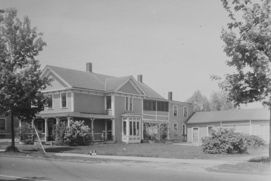
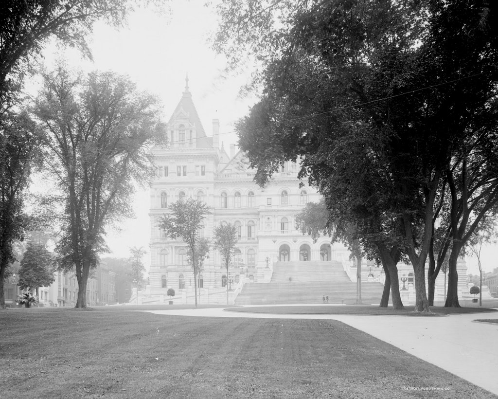
The New York State Capitol, seen from Eagle Street on the east side of the building, around 1900-1906. Image courtesy of the Library of Congress, Detroit Publishing Company Collection.

The capitol in 2019:

For a state capital, the city of Albany is relatively small, with a current population of just under 100,000. This modest size is even more apparent when contrasted with New York City, which is nearly a hundred times larger than Albany. However, while the city itself might be small, New York more than makes up for it with one of the most impressive state capitol buildings in the country, which stands here on a hill just to the west of downtown Albany.

Albany became the capital of New York in 1797, and for much of the 19th century the state government was housed in a capitol building that stood on the far left side of this scene, directly in front of what is now the southeastern corner of the current capitol. This building was completed in 1809, and it remained in use even as its much larger replacement rose behind it in the late 1860s and 1870s. The state legislature finally moved into the yet-unfinished capitol in 1879, and the old one was demolished in 1883, although the new one would not be completed until 1899, after many years of construction delays and cost overruns.

Work on the new capitol had begun in 1867, and its initial design was the work of Thomas Fuller, a Canadian architect who had previously been involved in designing the buildings on Parliament Hill in Ottawa. His plans called for a Renaissance Revival exterior, although the construction work had only progressed as far as the ground floor by 1875, when he was dismissed from the project. The state then hired architects Leopold Eidlitz and Henry H. Richardson, who designed the next two floors before they too were dismissed in 1883 by then-Governor Grover Cleveland. Both Eidlitz and Richardson were pioneers of the Romanesque Revival style of architecture, and their involvement is visible in the exterior design of these two floors, which are significantly different from the ground floor.

Architect Isaac G. Perry then oversaw the final stage of construction, although Eidlitz and Richardson continued to be involved in the design process, and the upper floors have many of the same Romanesque features as the second and third ones. The capitol was also intended to have a Romanesque-style tower in the center, although this was ultimately never completed, in part because of concerns that the ground beneath the building would be unable to support its weight. However, financial issues likely played a role in this decision as well. By the time the building was declared completed in 1899, its original estimated construction costs had ballooned to a staggering $25 million, equivalent to over $750 million today. Finishing the tower would have meant spending even more money, not to mention prolonging a project that was already nearly a third of a century in the making.

The first photo was taken shortly after the capitol was completed, showing the large exterior staircase on the eastern facade of the building. It has a total of 77 steps and extends outward 166 feet from the front of the building. Built in the 1890s, it was one of the last major exterior features added to the capitol, and it was designed by Isaac Perry. He had also intended to build a large gable above the entrance, similar to the one on the west side of the building. However, structural concerns about the added weight forced him to abandon this plan, and he instead built a balcony over the entrance.

Unfortunately, the building’s troubles did not end with its completion. In the early morning hours of March 29, 1911, a fire started in the Assembly Library on the third floor. It soon spread to the nearby State Library, where hundreds of thousands of irreplaceable books and manuscripts provided more fuel for the blaze. By the time the fire was brought under control, the library was a total loss, and the fire caused extensive damage to the upper floors on the western side of the building, including the collapse of the tower at the southwestern corner. The fire also claimed the life of the State Library’s night watchman, 78-year-old Civil War veteran Samuel Abbott, whose charred body was found under the debris two days later.

The eastern side of the building, shown here in these photos, was unaffected by the fire. This included the governor’s Executive Chamber, located on the second floor in the southeast corner, on the left side of this scene. The flames did not reach the legislative chambers, which are located on either side of the building in the center of the east-west axis, but both rooms suffered water damage, and the legislators temporarily met across the street in City Hall while the capitol was repaired. In the end, the fire caused over $2 million in damage to the building, not to mention the priceless contents of the State Library, and none of these losses were insured by the state. The exact cause of the fire was never determined, but the most likely culprit was faulty electrical wiring, which had been installed in the early years of electric lighting.

Overall, though, despite the early troubles of the capitol building, it has stood here as a major landmark for well over a century. During this time, it has seen the rise of many notable politicians, particularly governors, who have gone on to achieve national prominence. Three of the governors who served here in this building subsequently became president: Grover Cleveland (1883-1885), Theodore Roosevelt (1899-1900), and Franklin D. Roosevelt (1929-1932). Of these, both Cleveland and Franklin Roosevelt were sitting governors when they were elected to the presidency, and Theodore Roosevelt was the governor when he was elected vice president in 1900.

Other prominent governors have included Charles Evans Hughes (1907-1910), who later became Secretary of State and Chief Justice of the United States; Al Smith (1919-1920, 1923-1928), the 1928 Democratic presidential candidate; and Thomas E. Dewey (1943-1954), who ran for president as the Republican candidate in both 1944 and 1948. The 1944 presidential election was particularly interesting in that it pitted the sitting New York governor against a former governor, Franklin Roosevelt. More recently, Nelson Rockefeller (1959-1973) served as vice president under Gerald Ford, after his 14-year tenure here as governor. Another vice president, Levi P. Morton, was also governor (1895-1896), although he was not elected to this office until after his term as vice president.

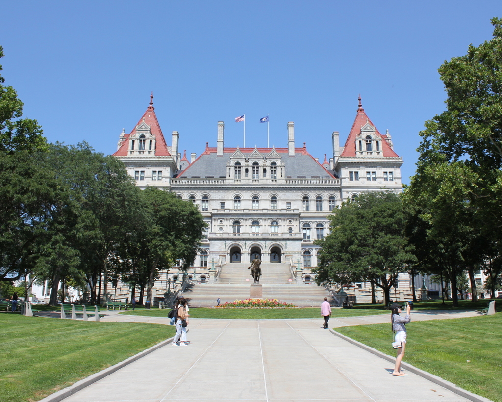
Today, more than a century after the first photo was taken, much has changed in the area surrounding the capitol, particularly to the south on the left side of the scene. During the Rockefeller administration, all of the buildings in the blocks to the south of the capitol were demolished as part of a large urban renewal project in order to create the Empire State Plaza, a sprawling complex of state office buildings. Although not visible in this particular view, the Modernist and Brutalist-style buildings of the plaza provide a sharp contrast to the elaborate 19th century architecture of the adjacent capitol building.

As for the capitol itself, it has undergone interior renovations over the years, but on the exterior it remains essentially the same as it did at the turn of the 20th century. It has been a source of controversy over the years, both for its expense and for its visual appearance as an odd hybrid of Renaissance and Romanesque architectural styles. However, it remains in use as the capitol of one of the largest states in the country, and it is probably the most recognizable historic landmark in the city of Albany.

Kenmore Hotel, Albany, New York

The Kenmore Hotel, at the corner of North Pearl and Columbia Streets in Albany, around 1900-1906. Image courtesy of the Library of Congress, Detroit Publishing Company Collection.

The building in 2019:

The Kenmore Hotel, shown here in these two photos, is one of the most impressive 19th century commercial buildings in Albany. It was built in 1878, with an ornate brick High Victorian Gothic-style exterior that was designed by local architect Edward Ogden and it was owned by Adam Blake, a prosperous African American hotelier.

Blake was born in 1830, and he was subsequently adopted by—and named for—Adam Blake Sr., a former slave who was a leader within the local African American community. He went on to have a successful career in the restaurant and hotel industries, eventually becoming the owner of the Congress Hall hotel. This hotel was ultimately demolished to make way for the new state capitol building, but Blake received $190,000 for it—equivalent to over $5 million today—and he used the money to build the Kenmore Hotel here on North Pearl Street.

The hotel featured the latest in modern conveniences, with an 1880 advertisement declaring that it had an “Elevator, along with all modern appliances for Elegance and Comfort” and “Hot and Cold Water, Steam Heaters, and Telephone, connecting with office, in each room.” The latter was a particularly remarkable innovation, as Alexander Graham Bell had developed the first telephone in 1876, and within just four years every room in this hotel was equipped with one.

Blake ultimately did not get to enjoy his new hotel for very long, though, because he died in 1881 at the age of 51. However, he left behind a substantial estate of over $100,000, or more than $2.6 million today, and his widow Catherine carried on the hotel business for several more years before selling it in 1887.

During this time, the hotel was a popular gathering place for state politicians, who worked just up the hill from here at the state capitol. These included 25-year-old Theodore Roosevelt, who was at the time an assemblyman from New York City. In 1883, he made the hotel his base of operations during his bid to become speaker of the State Assembly. He ended up losing in the Republican caucus to Titus Sheard, although in the long run this defeat did not seem to have hurt his political career.

Around the turn of the 20th century, Robert P. Murphy acquired the hotel, renovated it, and rebranded it as the New Kenmore. The first photo was taken around this time, and the building displays a vertical “New Kenmore” sign on the right side. The photo also shows some of the other nearby commercial buildings on North Pearl Street, which were built around the same time as the Kenmore. These include the YMCA Building, visible in the distance with the gabled roof and rounded turret at the corner of Steuben Street. It was built in 1886, and in 1892 it was the site of one of the first basketball games. The sport had been invented only a month earlier at the YMCA Training School in Springfield, Massachusetts, and this game in Albany was the first to be played outside of Springfield.

Robert Murphy sold the hotel in 1906 and opened a new hotel in New York, but he returned to Albany in 1916 and ran the Kenmore until his death in 1921. His sons Harry, Robert, and Augustus then carried on the business for many years, and it was during this time that the hotel became well known as the site of the Rain-Bo Room nightclub. The club featured live performances by prominent entertainers of the Roaring Twenties and beyond, including Duke Ellington and Frank Sinatra, and one of its regular guests was the famous mobster Jack “Legs” Diamond.

The Rain-Bo Room closed in 1947, and in 1986 the building was converted into offices. The building is now undergoing another renovation, as shown in the 2019 photo. Upon completion, the building will feature 93 apartments, along with retail space on the ground floor, and there is also a proposal to reopen the Rain-Bo Room. Overall, despite the changes in use over the years, the Kenmore has remained very well-preserved, with few significant changes since the first photo was taken. The neighboring buildings further to the left are also still standing, and they are now part of the Downtown Albany Historic District, which was added to the National Register of Historic Places in 1980.

Union Station, Albany, New York

The platforms on the east side of Union Station in Albany, around 1904. Image courtesy of the Library of Congress, Detroit Publishing Company Collection.

The scene in 2019:

Taken nearly 120 years apart, these two photos capture one of the ways in which transportation changed in the United States over the course of the 20th century. The first photo shows a large, recently-completed downtown railroad station, with several trains waiting on the tracks and a group of people on one of the platforms. However, in the present-day scene the railroad station has been converted into offices, while the tracks and platforms are completely gone, replaced with a parking garage. Another even larger parking garage stands in the distance on the right side, and further to the right, just out of view, is an interstate highway.

Albany’s Union Station was completed in 1900, and it was primarily used by the New York Central and Hudson River Railroad. However, it was also used by the Delaware and Hudson Railway and the New York Central-controlled West Shore Railroad, and it was the western terminus of the Boston and Albany Railroad, which the New York Central had begin leasing earlier in 1900. The station building featured a granite, Beaux-Arts exterior, and it was designed by the prominent Boston architectural firm of Shepley, Rutan and Coolidge. This firm was particularly well-known for their railroad stations, and they designed a number of them for the Boston and Albany, including Union Station in Springfield and South Station in Boston.

The station was built at the corner of Columbia Street and Broadway, with the main entrance on the western side, facing Broadway. However, this view shows the other side of the station, looking north from the southern end of the platforms. Here, three large island platforms were situated between the tracks, and passengers could access them via two underground tunnels. The train on the left side of the first photo is a New York Central passenger train, with 4-4-0 locomotive number 1135 in the lead. Another unidentified locomotive stands on the far right side of the photo, and further in the distance just to the left of that train is a group of men—possibly railroad employees—leaning against and sitting on a row of baggage carts. These trains were just two of the 96 daily trains that served Union Station when it first opened at the turn of the 20th century. Of these, there were 42 New York Central trains, 31 Delaware and Hudson, 13 West Shore, and 10 Boston and Albany.

Passenger rail travel continued to increase nationwide throughout the first half of the 20th century, eventually peaking during World War II. This was also the busiest time for passenger trains in Albany, with 121 daily trains here at Union Station. However, the postwar period saw a sharp decline in ridership, a problem exacerbated by the development of the Interstate Highway System starting in the 1950s. By the 1960s, many of the railroad companies that had dominated the nation’s economy a half century earlier were now teetering on the brink of bankruptcy. As a result, the New York Central merged with its longtime rival, the Pennsylvania Railroad, in 1968, forming the Penn Central Railroad.

For nearly a decade prior to the merger, the New York Central had been looking to rid itself of Albany’s Union Station, which was under-utilized and expensive to maintain. The station was also near the path of the planned Interstate 787, which would cut through part of the station’s passenger yard. Soon after the formation of Penn Central, the newly-formed railroad opened a new, much smaller passenger station directly across the river from here in Rensselaer, and the old Albany station was unceremoniously closed on December 29, 1968.

A few months later, the New York Times published an “obituary” of the station, titled “In Melancholy Memory of Albany’s Union Depot.” The article lamented the closure of the grand station, recalling its long history during the heyday of passenger trains and contrasting its architecture with that of the new station, which was described as a “one-story crackerbox of concrete blocks.” At the time, the fate of the old station was still undetermined, but the article mentioned several different proposals, which ranged from converting it into a museum to demolishing it and building a high-rise luxury apartment building and marina on the site.

Ultimately, neither of these proposals materialized, and the building was instead converted into offices in the 1980s. It was originally the home of Norstar Bancorp, and it was initially named Norstar Plaza, although it was subsequently renamed Peter D. Kiernan Plaza after the death of the bank’s president. The bank then went through a series of mergers, and over the next two decades the building was home to Fleet Financial Group, FleetBoston Financial, and then Bank of America. The building was used by Bank of America until 2009, and it now serves as offices for several other companies.

Overall, the present-day scene is drastically different from the view in the early 20th century. The most dramatic change is the parking garage in place of the station tracks and platforms, but other changes have included the tall building just beyond the station on the other side of Columbia Street. However, the station itself has not seen many exterior changes since the first photo was taken, even though much of it is hidden by trees from this angle. Today it stands as an excellent work of Beaux-Arts architecture, and it also serves to highlight the benefits of historic preservation and adaptive reuse.

Ambrose O. Smith House, Springfield, Mass

The house at 178 Boston Road in Springfield, around 1938. Image courtesy of the Springfield Building Department.

The scene in 2019:

As discussed in the previous post, Boston Road in Springfield was a sparsely-settled area prior to the turn of the 20th century. Most city maps throughout the 19th century show fewer than 20 houses along its entire 3.3-mile length from present-day Berkshire Avenue to the Wilbraham town line. This house, which was probably built around the mid-19th century, was one of those widely scattered houses, standing along Boston Road in what would eventually become the Pine Point neighborhood.

The early history of this house is difficult to trace because the outlying parts of the city did not have street numbers at the time, but a house appears near this spot on the 1835 map of Springfield. It was owned by John Butler, but it does not seem clear as to whether this is the same house from the first photo, because it is not shown on the 1855 county map. Probably the best indicator for the house’s age is its architecture, which features a blend of Greek Revival and Italianate elements. This style was particularly popular here in Springfield prior to the Civil War, so the house likely dates back to around the 1850s.

The first verifiable owner of this house was Ambrose O. Smith, who was living here by 1866. Born in Middlefield Massachusetts in 1829, Smith moved to Springfield in the mid-1860s, and during the 1870 census he was living here with his mother Nancy and his sister Mary C. Otis. He and his family lived here until at least 1872, but by 1873 he had moved to a house at 46 Walnut Street, where he was listed in the 1880 census as being a milk dealer. However, he continued to own this house for many years. He moved back here by the mid-1880s, and soon after he became one of the first landowners in this part of the city to subdivide his property into new streets and house lots.

Prior to the late 19th century, this area, which is located three miles east of downtown Springfield, was not a particularly desirable place to build houses. But, as the city grew in the post-Civil War era, developers began creating new residential neighborhoods to meet the increased demand for single-family homes. This was aided in part by the opening of trolley lines across the city, and by the 1890s one of these lines passed through modern-day Pine Point, connecting downtown Springfield to Indian Orchard.

Likely motivated by his land’s proximity to the trolley line, Ambrose O. Smith turned his Boston Road farm into a residential subdivision. His property extended behind this house as far north as Berkshire Avenue, and he also owned the land across the street on the south side of Boston Road, as far south as the North Branch of the Mill River. The 1899 city atlas shows a number of streets that had been laid out across his property, with Jasper Street on the north side, and Ambrose, Boyer, Coleman, Denver, Embury, and Falmouth (now Devonshire) streets on the south side. The land along these streets was divided into individual lots, although very few of them had been developed at this point. Aside from a handful of houses on Coleman Street, nearly all of these lots were still vacant in 1899.

Smith was still living in this house in 1899, but by the 1900 census he was on Lenox Street in Forest Park, and he died in 1904. The next long-term resident of this house was Joseph M. LaRiviere, who was living here as early as 1901. During the 1910 census he was 54 years old, and he lived here with his 44-year-old wife Evalena and their 23-year-old son Victor. Around this time, he sold postal cards in a shop on Main Street, while Evalena was a dressmaker and Victor worked as a clerk in Indian Orchard.

The LaRiviere family was still living here a decade later during the 1920 census, but by this point they had apparently divided the house into several different apartment units, because the census also shows two other families living here. They moved out soon after, though, because the 1921 city directory shows Joseph and Evalena living in a house on Douglas Street in the North End.

By the 1930 census, three families were renting apartments in this house, and their monthly rents ranged from $20 to $28. In one unit was Corinne LaTaille, a 36-year-old widow who lived here with her three children. Five years earlier, while living in a house on Denver Street, her husband Frank had committed suicide. According to contemporary newspaper accounts, this was likely caused by his recent two-month jail sentence for driving under the influence of alcohol, along with unspecified “family troubles.” The latter may have been related to the fact that, just two weeks after his death, Corinne gave birth to twin boys.

The other two families living here in 1930 included 44-year-old Charles and Annie Edson, who lived in an apartment with their six young children. Charles worked as a machine operator in a factory, and the family’s stay here was evidently short, because in 1929 they had been in a house on Denver Street, and within a few years they had moved elsewhere. The third tenant here in 1930 was George E. Miller, a 57-year-old radio mechanic who lived here with his 63-year-old wife Idella and their 29-year-old son George.

The first photo was taken in 1938, and two years later the 1940 census shows three more families living here. The rents had declined somewhat since 1930, likely because of the Great Depression, and all three tenants paid $20 per month. In one unit was John and Flora Kenney, in the second was Adele Rieck and her son Royal, and in the third was Arthur and Anna Allen and their young children Dorothy and George. Of all the residents here, Arthur was the only one who had been employed full-time in the previous year, earning $1,560 while working in a hotel laundry. During that same time, John Kenney worked for eight weeks as an inspector at the Armory, earning $203, while Royal Rieck earned $20 for two weeks as an elevator operator.

It is difficult to trace the subsequent fate of this house, but it appears to have still been occupied by residents as late as the early 1950s. However, by the mid-1950s this lot had become the junkyard of City Towing Service, although it seems unclear whether or not the house was still standing on the site. Then, in 1963 the property became the Pine Hill Motors car dealership. Its name has changed several more times since then, but this site continues to be a car dealership, and today the only surviving remnant from the first photo is the adjacent house on the far left at 168 Boston Road, which is still standing.

William G. Pierce House, Springfield, Mass

The house at 171 Boston Road, at the corner of Coleman Street in Springfield, on October 4, 1938. Image courtesy of the Springfield Building Department.

The house in 2019:

Today, Boston Road a busy four-lane road, lined with gas stations, restaurants, shopping plazas, used car dealerships, and other commercial development for most of its 3.3-mile length from Pine Point to the Wilbraham town line. However, as discussed in a previous post, this section of Springfield was lightly populated prior to the early 20th century. While passing through here in 1789, George Washington had described the area as “an almost uninhabited Pine plain,” and not much would change for another century, despite being located on the main route from Springfield to Boston. Much of this had to do with the poor quality of the soil, which made the land undesirable for farming. Distance was also a factor in this; modern-day Pine Point is about three miles from downtown Springfield, which made it impractical to commute into the city on a daily basis.

However, things had begun to change by the late 19th century, when a number of Boston Road landowners began subdividing their properties with new streets and house lots. This was likely spurred by the opening of a trolley line nearby on Berkshire Avenue, which linked downtown Springfield to Indian Orchard. Residents here could now commute to either location, or take connecting lines to other destinations, and by the early 20th century Pine Point had been transformed into a working class suburban neighborhood.

Over the years, nearly all of the old homes here on Boston Road have been demolished, either to clear the way for a new subdivision or to repurpose the land for commercial use. This house, located at the corner of Boston Road and Coleman Street, appears to be the oldest surviving house on Boston Road, and probably the only one that predates the development of the modern street grids.

It is difficult to determine the exact date when this house was built, in part because houses in the outlying areas of the city generally did not have street numbers during the 19th century. Various maps show houses in this vicinity as early as 1835, but it is not easy to tell exactly which houses were which. The documentation on the state’s MACRIS database lists it as having been built around 1882, based on atlases and directories of the period, and this seems like a plausible date, particularly since its Queen Anne-style design matches with architectural tastes of the early 1880s. In many ways, its design resembles a smaller version of the much larger Queen Anne houses that were built in the city’s McKnight neighborhood around the same time.

The first recorded resident of this house was William G, Pierce, who appears in the 1882 city directory as a merchant of the firm William G. Pierce & Co. However, he is not listed in either the 1881 or 1883 directories, so his stay here at this house may have been short. The next 15 years of this house’s history are unclear, but by 1897 it was owned by Julien W. Belanger, a merchant tailor who lived here with his wife Corinne, their five children, and a servant. His tailor shop was located on Main Street in downtown Springfield, and he likely would have used the new trolley line to commute to work. He and his family were living here as late as 1900, but by 1901 they had moved to Adams Street, and by 1904 they had moved to Canada, where both Julien and Corinne had been born.

By 1905, this house was being rented by Michael and Mary Byrne, who lived here with their four children. Like the Belangers, they were also immigrants, with Michael from Scotland and Mary from England. In city directories of the period, Michael is listed as a papermaker, although according to the 1910 census he was an automobile machinist. The census also lists their son Adam as having the same occupation, while their daughter Mary was a saleswoman at a department store, and their son Charles was an assistant bookkeeper at a department store.

The Byrne family left Springfield soon after the 1910 census, and by 1912 this house was owned by Albin M. Kramer, a civil engineer who had immigrated to the United States from Germany as a young child in 1872. His wife Rose was also an immigrant, from England, and they had married within a few years after her arrival in 1899. During the 1920 census, they were living here in this house with their children Alwin, Frederick, Vincent, and Marguerite, who ranged in age from 10 to 16.

Of the four Kramer children, Alwin would probably go on to have the most noteworthy career. He was 16 years old during the 1920 census, and a year later he graduated from Central High School. From there he went to the U. S. Naval Academy thanks to an appointment by Springfield’s Congressman Frederick H. Gillett, who was at the time the Speaker of the House. Alwin went on to have a long career in the Navy, but he is best remembered for his role in the events leading up to the attack on Pearl Harbor.

In 1939, Alwin became the head of OP-20-GZ, which was involved in intercepting, decrypting, and translating coded messages sent by the Japanese government. He was particularly busy in early December 1941, when his office decrypted a series of 14 messages sent to the Japanese embassy in Washington D.C. The last of these, sent in the early morning hours of December 7, instructed the Japanese ambassador to end diplomatic relations with the United States. However, it did not specifically indicate that an attack or a declaration of war was imminent, and there were a number of delays in Washington before this information was finally sent to Pearl Harbor, arriving several hours after the attack.

Alwin Kramer would go on to serve with distinction in World War II, and was eventually promoted to captain. However, his actions in early December, and those of his colleagues and superiors, fell under increased scrutiny after the war, eventually leading to a Congressional inquiry in 1946. The hearings were likely politically motivated, in an attempt by Republicans to discredit the Roosevelt and Truman administrations, but Captain Kramer did himself no favors with his confusing and often contradictory testimony, and he ended up retiring from the Navy by the end of the year. Nonetheless, he was never formally assigned any blame, and his wartime promotions suggest that his superiors in the Navy did not find fault in his actions. He died in 1972 at the age of 69, and he was buried in Arlington National Cemetery.

In the meantime, Kramer’s family continued to live here in his childhood home until around 1929, although by the 1930 census his parents and two younger siblings were living in a house at 127 Massachusetts Avenue. The next long-term residents here at 171 Boston Road were Walter and Mazie Spickler, who were here as early as 1933. They were both in their mid-40s at the time, and they lived here with their son George and his wife Edna. George and Edna subsequently moved to a house of their own on nearby Denver Street by 1937, but Walter and Mazie were still here on Boston Road when the first photo was taken in 1938. According to the 1940 census, they paid $37 per month in rent, and Walter earned $1,560 per year as a fireman at a cotton mill.

Walter Spickler died shortly after the census was taken, in September 1940, at the age of 54. Mazie continued to live here for at least a few more years, and the 1944 city directory shows her working as an inspector at Westinghouse. However, she moved by the following year, because the 1945 directory shows Franklin and Virginia Lewis living here. At the time, Franklin was working as a collector for the Springfield Union newspaper, and he later became the circulation supervisor for the Springfield Newspapers. He lived here until his death in 1969, at the age of 64. It seems unclear as to how much longer Virginia lived here, but she ended up outliving Franklin by more than 40 years, before her death in 2010 at the age of 104.

Today, more than 80 years after the first photo was taken, remarkably little has changed in this scene. The property is now surrounded by a chain link fence, and the house appears to have a different paint scheme, but otherwise its exterior looks essentially the same as it did in the 1930s. The shed in the backyard on the far left is also still there, as is the brick building on the far right side. Although mostly hidden by trees in the first photo, this building was here in the 1930s, and it is best known as the site of the first Friendly’s restaurant, which opened here in 1935. In general, very few historic buildings have survived the various waves of development along Boston Road, but this house stands as an unusual reminder of what Springfield’s main commercial thoroughfare once looked like.

East India Marine Hall, Salem, Mass

East India Marine Hall on Essex Street in Salem, around 1910-1920. Image courtesy of the Library of Congress, Detroit Publishing Company Collection.

The scene in 2019:

The Peabody Essex Museum in Salem is one of the oldest museums in the United States, with a complex lineage that traces back to 1799, with the formation of the East India Marine Society. At the time, Salem was one of the most prosperous seaports in the country, with merchants who were among the first Americans to trade with southeast Asia. The society was established by local captains with several goals, including sharing navigational information, providing aid to families of members who died, and collecting artifacts and other interesting objects from the East Indies. Membership was limited to captains and supercargoes of Salem vessels who had sailed beyond either the Cape of Good Hope or Cape Horn.

The organization moved into its first permanent home in 1825 with the completion of East India Marine Hall, shown here in these two photos. The building was formally dedicated on October 14 of that year, in a ceremony that was attended by many noted dignitaries. These included President John Quincy Adams; Congressman and former Secretary of the Navy Benjamin W. Crowninshield; Associate Justice Joseph Story of the U. S. Supreme Court; former Senator, Postmaster General, Secretary of War, and Secretary of State Timothy Pickering; and famed navigator and mathematician Nathaniel Bowditch.

The building was designed by Boston architect Thomas Waldron Sumner, and it features a Federal-style design with a granite exterior here on the main facade, which faces Essex Street. Originally, the main entrance was located in the center of the building on the ground floor, and it was flanked by storefronts on either side. These storefronts have long since been altered, but the names of the first two commercial tenants—the Asiatic Bank and the Oriental Insurance Company—are still carved in the granite above the ground floor. The East India Marine Society itself was located on the second floor, which consisted of a large open hall.

Despite the grand celebration for the completion of this building, though, Salem was already in decline as a seaport. Both the Embargo Act of 1807 and the subsequent War of 1812 had crippled Salem’s shipping, and it never fully recovered, with much of the international trade shifting to other northeastern ports, such as Boston and New York. Elsewhere in New England, the region’s economy was transitioning from trade to manufacturing, and Salem’s growth had stagnated by the mid-19th century, even as nearby industrial cities such as Lowell experienced rapid increases in population.

Because of this, the East India Marine Society faced dwindling membership, and by the 1850s it began considering selling objects from its collections in order to remain financially viable. However, prominent London financier George Peabody—a native of the neighboring town of Peabody—intervened, and in 1867 he established a $140,000 trust fund. The museum was then reorganized as the Peabody Academy of Science, for the “Promotion of Science and Useful Knowledge in the County of Essex.” As part of this, the natural history collections of the Essex Institute, which had been established in Salem in 1848, were transferred to the Peabody. In exchange, the Essex Institute received the Peabody’s history collections.

The Peabody Academy of Science continued to use the East India Marine Hall, but over the years it made some significant alterations to the building. In the mid-1880s the museum added a wing, known as Academy Hall, to the southeast corner of the original building. It stands in the distance on the left side of the first photo, and the sign for it is visible just beneath the awning. Then, in 1904 the storefronts were removed and replaced with museum exhibit rooms, and around this time the original front entrance was also closed. A new one-story entryway was then built on the right side of the building, as shown in the first photo. This photo also shows a large anchor in front of the building. It was made sometime around the turn of the 19th century, and it was donated to the museum by the United States Navy in 1906.

In 1915, around the same time that the first photo was taken, the Peabody Academy of Science was renamed the Peabody Museum of Salem. Throughout the 20th century, the museum continued to expand with more additions, reaching as far back as Charter Street on the other side of the block. From here on Essex Street, probably the most visible change was the addition of a large Brutalist-style wing on the left side of the original building, which was completed in 1976.

Then, in 1992 the Peabody Museum of Salem merged with the Essex Institute, forming the Peabody Essex Museum. Since then, its facility has grown even more, with new wings that were completed in 2003 and 2019. This most recent addition, which opened the same year that the second photo was taken, was built on the right side of this scene. It involved the demolition of the old 1904 entryway from the first photo, and now the original East India Marine Hall is almost completely surrounded by newer buildings. However, the main facade has remained largely unchanged throughout this time, and it remains an important landmark in downtown Salem nearly two centuries after its completion.