Mount Vernon Street, Boston

Looking west on Mount Vernon Street from near the corner of Walnut Street in Boston’s Beacon Hill neighborhood, around 1860. Image courtesy of the Boston Public Library.

The scene in 2021:

For more than two centuries, Beacon Hill has been one of the most desirable residential neighborhoods in Boston. During the colonial period, this area was primarily hilly pastureland on the outskirts of town, but in 1798 it became the site of the Massachusetts State House, which still stands at the southeastern corner of the neighborhood. Residential development soon followed, consisting largely of brick, Federal-style row houses. Over the years, many prominent people have lived here on Beacon Hill, and it remains a remarkably well-preserved early 19th century neighborhood.

These two photos show the view looking west on Mount Vernon Street from the corner of Walnut Street, near the crest of the hill. Nearly all of the buildings from the first photo are still standing more than 160 years later, with the exception of the one on the far right, which was demolished around 1905-1910 in order to build the current Tudor Revival-style building. Aside from this one, the other houses on the right side of the street in this scene all date back to the first half of the 19th century. The two closest to the foreground, just past the Tudor-style building, were both built in the 1830s, and the both feature a bowed front façade, which is a distinctive feature on many Beacon Hill homes.

On the left side of the street, the most distinctive houses are the two brownstone homes in the foreground at 40 and 42 Mount Vernon Street. These were among the first houses in the neighborhood to be built of brownstone rather than brick, and they were both designed by architect George Minot Dexter. Both were built for prosperous merchant Augustus Hemenway, who lived in the house at the corner, at 40 Mount Vernon Street. He was still living here when the first photo was taken around 1860, and both houses remained in his family until the early 20th century.

Just past these houses are three comparatively modest brick rowhouses, which were built around 1825, and further in the distance are three single-story buildings. These are probably the oldest buildings in this scene, dating back to 1804 when they were built as carriage houses for homes on nearby Chestnut Street. Despite their small size and humble origins, all three have survived to the present day, and have since been converted into residences.

Overall, with the exception of the present-day cars and paved roads, very little has changed in this scene since the first photo was taken. This is generally true throughout much of the neighborhood, and because of this level of preservation, Beacon Hill was designated as a National Historic Landmark district in 1962.

King’s Chapel Burying Ground, Boston

The scene in the King’s Chapel Burying Ground in Boston, around the 1920s. Image courtesy of the Boston Public Library.

The scene in 2021:

King’s Chapel Burying Ground is the oldest cemetery in Boston, dating back to the very beginning of the European colonization of the area. According to tradition, the first burial here was Isaac Johnson, one of the wealthiest and most influential of the original settlers of the Massachusetts Bay Colony. He had extensive landholdings, but he died in September 1630, only a few months after his arrival in the New World. As the story goes, Johnson was buried on his property in Boston, and as other people died in the coming months and years, they were likewise buried here.

In reality, there is no contemporary evidence to indicate that Johnson was even buried in Boston, let alone in this specific plot of land. The earliest account of this story was written nearly 50 years after the fact, in the diary of Judge Samuel Sewall. But, one way or another, this site became a burial ground very early in Boston’s history, although the exact date is uncertain. It would remain the town’s only cemetery until 1659, when Copp’s Hill Burying Ground was established in the North End.

There are no surviving gravestones from the early burials here. The oldest is dated 1658, for William Paddy, although this stone had an interesting history. Paddy was presumably buried here at King’s Chapel, but the gravestone itself was discovered buried under the street next to the Old State House in 1830. It seems highly unlikely that Paddy would have been buried there, and there were no human remains in the vicinity, so the stone was probably removed from the burying ground at some point, perhaps in the 1700s, and repurposed as something else. In any case, it was safely returned here after its discovery in 1830, and has remained here ever since.

Gravestones became more common here during the late 1600s and early 1700s, often with highly ornate, intricate carvings decorated with images of skulls and other symbols of death. Perhaps most notable among them is the gravestone of Joseph Tapping, a large slate stone that stands at the entrance to the graveyard. It is dated 1678, and it features a scroll pediment at the top, and beneath it is a large hourglass atop a winged skull. Beneath the skull is a striking image of a skeleton, likely symbolizing death, trying to extinguish a candle while Father Time tries to restrain him. Another notable gravestone is that of Elizabeth Pain, dated 1704. It likewise features a skull and hourglass, but it also has a large coat of arms carved into it. This design somewhat resembles a capital “A,” which has led some to speculate that this gravestone inspired Nathaniel Hawthorne to write The Scarlet Letter.

In the meantime, in 1688 King’s Chapel was built on the southern portion of the graveyard. It was the first Anglican church in a town that was otherwise dominated by Puritanism, and this was the only land that the church officials were able to acquire. It was originally built of wood, although it was later rebuilt with stone in 1754, as shown in these two photos. The church was not at all affiliated with the graveyard, but, because of its proximity, it came to be known as King’s Chapel Burying Ground, and the name has stuck ever since.

The graveyard continued to be used throughout the 18th and into the early 19th centuries. However, by that point Boston was growing rapidly, and the old burial grounds such as this one were becoming overcrowded and, in the minds of many, posed health risks. So, in 1831 the Mount Auburn Cemetery was established in Cambridge and Watertown, in the suburbs of Boston. In contrast to the crowded, urban setting here, this new cemetery would be laid out like a rural park. And, while the old graveyards featured gravestones with grim, Puritan-era reminders of death, Mount Auburn would have monuments that were generally more neoclassical in style.

By the time the first photo was taken around the 1920s, King’s Chapel Burying Ground had not been used as an active cemetery for many decades. And, in the meantime, many of the old gravestones had been rearranged during the 19th century, evidently to create more orderly rows of stones. As a result, the location of many of the stones no longer corresponded to the site of the remains that they were intended to mark. This practice continued after the first photo was taken, and today the arrangement of the stones is very different from a century ago, as shown in the present-day photo.

Today, King’s Chapel Burying ground is a popular stop on the Freedom Trail, and a nice summer day will find many tourists circulating through the old graveyard. None of the particularly famous gravestones are readily visible in this scene, although the obelisk in the center of the photo stands out amid the otherwise relatively small colonial-era stones. It marks the gravesite of Thomas Dawes, a builder and architect who was also a militia colonel during the American Revolution. Just beyond the obelisk is a tomb that was long believed to have been the final resting place of William Dawes Jr., Thomas’s cousin. He had been one of the riders who, along with Paul Revere, warned of the advancing British redcoats before the Battles of Lexington and Concord. However, it appears that he is actually buried at the Forest Hills Cemetery in Jamaica Plain.

Aside from the graveyard itself, a few of the surrounding buildings are still standing from the first photo. Most notably is King’s Chapel itself, which remains an active church, although it has been a Unitarian congregation—rather than Anglican—ever since the end of the American Revolution. Further in the distance, on the right side of the scene, the other survivor from the first photo is the Tremont Building. Constructed in 1895, this office building still stands at the southwest corner of Tremont and Beacon Streets, and it is currently part of the Suffolk University campus.

Bigelow Chapel, Watertown, Mass

The Bigelow Chapel at Mount Auburn Cemetery in Watertown, around 1865-1885. Image courtesy of the New York Public Library.

The scene in 2021:

As explained in an earlier post, Mount Auburn Cemetery was established in 1831 as an alternative to the small, overcrowded colonial-era burial grounds in the center of Boston. By contrast, Mount Auburn cemetery was to feature winding paths, careful landscaping, and other features that made it not only a quiet final resting place for the dead, but also a pleasant place for the living to visit.

One of the leading figures in creating and subsequently managing the cemetery was Dr. Jacob Bigelow, a physician from Boston. He was involved in the cemetery throughout its early history, including the process of designing and building a chapel here in the cemetery. Working with noted architect Gridley J. F. Bryant, Dr. Bigelow helped to design the chapel. It featured a Gothic Revival design, which was particularly popular for churches and public buildings during this period, and it was completed in 1846.

However, problems soon emerged with the chapel. The contractors had submitted a bid of $19,623 for the project, but they evidently discovered, partway through construction, that this was too low. As a result, they hired less reputable subcontractors to do some of the work, with predictable results. The most significant problem was with the stonework. They used many poor-quality stones, and many of these were not cut to the proper dimensions, which allowed water to enter between the stones. Repeated freeze-thaw cycles in the winter months soon resulted in cracks in the stones, which threatened the structural integrity of the chapel.

To fix the problem, the building had to be demolished and reconstructed, with new stones to replace the defective ones. The work was completed in 1856, resulting in a building that looked essentially the same as the original one. The first photo was probably taken within a decade or two after this, showing a large gathering in front of the main entrance to the chapel.  It would remain in use as the cemetery’s chapel until 1898, when a larger one, which was later named the Story Chapel, opened at the main entrance to the cemetery.

The older chapel, which was formally named in honor of Jacob Bigelow in 1936, then became a crematorium. It was the first of its kind in the state, and is first cremation was in 1900. Since then, the interior has been significantly renovated several times, and the building was expanded with an addition in 1970. This wing now houses the crematorium, and the old chapel continues to be used as a meeting space for various events. Overall, despite these many changes, the view of the chapel from this angle has remained largely unchanged since the first photo was taken, and it stands as an excellent example of Gothic Revival architecture.

Slater Mill, Pawtucket, Rhode Island (2)

The view looking upstream on the Blackstone River in Pawtucket, around the 1860s or 1870s. Image courtesy of the New York Public Library.

The scene in 2021:

As explained in more detail in the previous post, Slater Mill is often regarded as the birthplace of the Industrial Revolution in America. It was built by Samuel Slater, an English-born textile manufacturer who secretly emigrated to the United States in 1789, bringing Britain’s industrial secrets with him. Upon arrival in New York, he soon made contact with Providence businessman Moses Brown, who was searching for someone to construct British-style water frames for spinning yarn. Slater subsequently came to Pawtucket, where he worked with several local craftsmen to produce a working water-powered spinning machine.

Slater then formed a partnership with Moses Brown’s son Obadiah Brown and son-in-law William Almy. They soon outgrew their original facility, so in 1792 they constructed a wood-frame dam across the Blackstone River, shown here in the center of these two photos. Then, a year later they opened their new mill, which was two stories high and measured 40 feet by 26 feet. It would later be significantly expanded over the years, but the original 1793 section is still there. Viewed from this angle, it is in the central part of the building, directly behind the large tree in on the left side of the present-day photo.

The original mill was small compared to the massive textile factories that would soon appear alongside major rivers throughout New England, and its operations were fairly limited, but it marked an important shift in manufacturing in the United States as the first large-scale cotton mill in the country. And, despite its initial small size, it soon expanded. The first addition came in 1801, with a large wing on the north side of the building, on the left side of this scene. This was followed by a wing on the south side in the late 1810s, and then a stair tower and cupola on the west side around 1830.

In the meantime, Samuel Slater remained a partner here throughout much of the early 19th century, but he also built a number of mills of his own, in part because of conflicts with Moses Brown and William Almy here at the original mill. He finally sold his interest in the company in 1829, when an economic downturn forced him to liquidate some of his assets in order to pay his debts.

This building would continue to be operated as a cotton mill throughout most of the 19th century. It was expanded with more additions during this time, and it also housed a variety of other tenants involved in different industries. The first photo shows the building around the 1860s or 1870s, standing alongside a number of other mills that had been built along the Blackstone River by this point.

Cotton production continued here until 1895, and the mill was subsequently used for other industrial purposes into the early 20th century. It was steadily deteriorating, but in 1923 it was acquired by the Old Slater Mill Association. Over the next few years, this organization restored the building to its 1835 appearance, including the removal of the later additions. Most of the surrounding buildings were also demolished, in order to create a small park around the old mill. Only the 1810 Oziel Wilkinson mill was spared, and it still stands just out of view on the left side of this scene.

Today, both the historic Slater Mill and the original dam across the river are still here. The mill was designated as a National Historic Landmark in 1966, and it is now a part of the Blackstone River Valley National Historical Park. Slater Mill is the centerpiece of this multi-site park, and it is joined here by the Wilkinson mill and also the Sylvanus Brown House, which was moved here from a different location in the mid-20th century.

Slater Mill, Pawtucket, Rhode Island

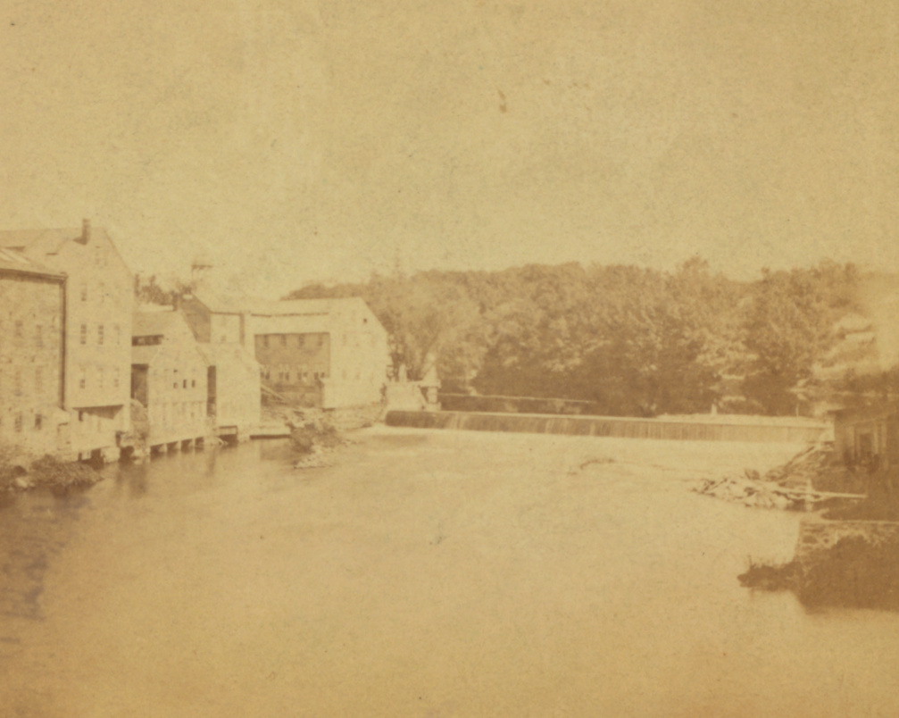
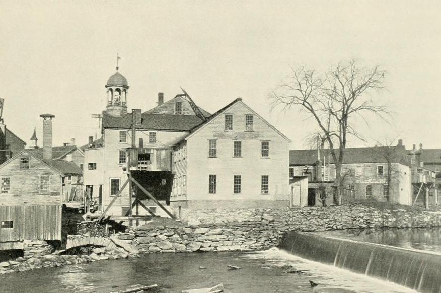
A view of Slater Mill on the Blackstone River in Pawtucket, around 1897. Image from An Illustrated History of Pawtucket, Central Falls, and Vicinity (1897).
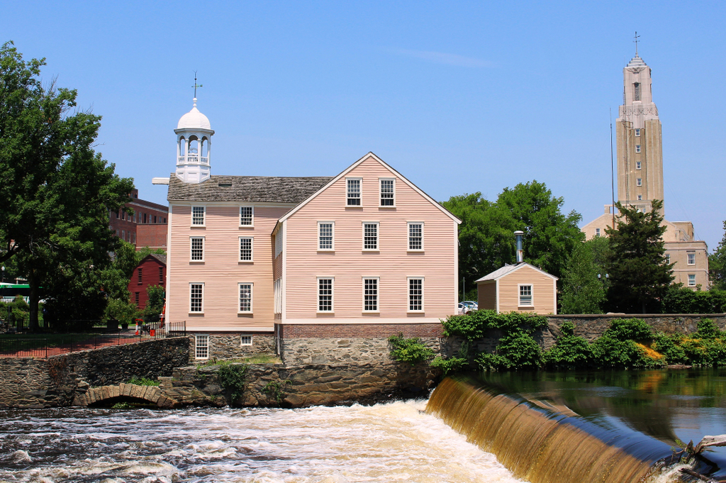
The scene in 2021:

This mill, located on the west side of the Blackstone River in Pawtucket, is an important landmark in the early history of the Industrial Revolution in America. The building has undergone many changes and expansions over the years, but the oldest portion—located in the central part of the building—was completed in 1793 by Samuel Slater, a British emigrant who is credited with bringing the Industrial Revolution to the United States.

The Industrial Revolution had started during the second half of the 18th century in Britain, where a series of inventors had developed ways of harnessing water power to spin thread and weave textiles. However, Britain closely guarded the details of these processes, in order to prevent foreign competition. This was also the case for the American colonies, where Britain discouraged manufacturing in order ensure that colonists purchased manufactured goods from the home country.

After gaining independence, the United States still found itself largely dependent upon British manufacturers, but many American entrepreneurs were interested in bringing these industrial innovations across the Atlantic. This was particularly true here in New England, where the region’s many fast-flowing rivers made it an ideal place for water-powered industry.

Among these early industrialists was Moses Brown, a member of a prominent family in Providence. His family had become wealthy during the colonial era as merchants and slave traders. In particular, his brother John was a notorious slave trader who continued the practice even after the federal government prohibited American ships from being used in the international slave trade. By contrast, Moses became a staunch abolitionist. He freed his own slaves, converted to Quakerism, and spoke out against both slavery and the slave trade. And, while his brother was still bringing enslaved people to America, Moses was looking to apply the new British textile manufacturing processes here in Rhode Island.

To accomplish this, in 1789 Moses established the firm of Almy & Brown, which was comprised of William Almy and Brown’s cousin, Smith Brown. Their goal was to make yarn, but they had poor-quality machinery and only limited knowledge about the manufacturing process, so it became clear that they needed someone who was familiar with the British system.

As it turned out, that person was 21-year-old Samuel Slater, who arrived in New York from England on November 18, 1789. He had been an apprentice at a textile mill in England, where he became familiar with the machinery that had been developed by inventor Richard Arkwright. In addition, he learned about the management side of the textile industry. So, by the time his apprenticeship term had ended, he not only knew how to build and maintain the machinery itself, but also how to operate a profitable factory.

However, by this point Richard Arkwright’s patents had expired, and Slater apparently believed that Britain would become too oversaturated with textile businesses. America, on the other hand, seemed to offer more potential for an aspiring young industrialist, and he knew that there were plenty of American entrepreneurs who were looking for someone with his knowledge and experience. With this in mind, he left England in September 1789, just two months after the end of his apprenticeship. Because of strict British laws against exporting machinery plans or drawings, Slater did not carry any with him, and he is said to have disguised himself as a farm laborer.

Upon arriving in New York, he soon heard of Moses Brown’s efforts to produce yarn, so he wrote to him on December 2, offering his services. Brown responded eight days later, and in his letter he explained the problem that his company faced:

We are destitute of a person acquainted with water-frame spinning; . . . As the frame we have is the first attempt of the kind that has been made in America, it is too imperfect to afford much encouragement;

He then went on to make his offer to Slater:

[W]e hardly know what to say to thee, but if thou thought thou couldst perfect and conduct them to profit, if thou wilt come and do it, thou shalt have all the profits made of them over and above the interest of the money they cost, and the wear and tear of them. We will find stock and be repaid in yarn, as we may agree, for six months. And this we do for the information thou can give, if fully acquainted with the business. After this, if we find the business profitable, we can enlarge it, or before, if sufficient proof of it be had on trial, and can make any further agreement that may appear best or agreeable on all sides.

These terms were acceptable to Slater, who traveled to Pawtucket in January 1790. However, once he arrived, he saw for himself the poor quality of the machinery, which was evidently worse than he had anticipated. Moses Brown would later tell Slater’s biographer, George S. White, that,

When Samuel saw the old machines, he felt down-hearted, with disappointment—and shook his head, and said ‘these will not do; they are good for nothing in their present condition, nor can they be made to answer.’

Slater then spent the next few months working on the machinery, with assistance from local craftsmen such as Sylvanus Brown and Slater’s future father-in-law, Oziel Wilkinson. They succeeded in constructing a water-powered spinning machine, and in April, Slater became a partner in the newly-established firm of Almy, Brown & Slater. A year later, Slater married Oziel Wilkinson’s daughter Hannah. She would go on to become an inventor in her own right, and in 1793 she became the first American woman to receive a patent when she developed a new way of making cotton sewing thread.

In the meantime, Slater’s machinery worked so well that the production of yarn soon outpaced the firm’s ability to sell it through their existing supply chains. However, once Slater and his partners began expanding into new markets, the original mill was unable to keep up with the increased demand. So, in the fall of 1791 the firm purchased this site here on the west side of the Blackstone River in Pawtucket, in order to construct a new mill. The wood-frame dam, shown here in the foreground of these two photos, was constructed in 1792, and the mill itself opened in 1793.

It was the first large-scale cotton mill in the United States, and it marked the beginning of an industry that would dominate the New England economy for more than a century. This building is still standing, in the center of these two photos, although it has been significantly expanded over the years. The original 1793 portion of the building was two stories high, and measured 40 feet long and 26 feet wide. It was built of wood, with a stone foundation, and it stood directly atop the Great Flume, which was built parallel to the river to provide water power for this mill and others further downstream.

Aside from his knowledge of textile machinery, Slater was also familiar with the management and operation of British mills, and he brought many of these innovations to America. Among these was the idea of continuous production, rather than the earlier practice of only making yarn to fill specific orders. Slater also took advantage of economies of scale, with his mill specializing in a relatively small number of products. More troublingly, though, Slater also copied the British practice of employing child laborers, and his workforce typically consisted of children between the ages of 7 and 12. However, unlike the British system, which tended to exploit orphans and other destitute children, Slater sought to develop factory villages that employed entire families. This approach, which came to be known as the Rhode Island System, involved having children produce yarn at the mill, and then have women weave the yarn into cloth at their homes.

By focusing on relatively small-scale industrial production of the yarn, along with having a decentralized weaving process, Slater’s Rhode Island System was in contrast to the subsequent Waltham-Lowell System, which would come to dominate New England textile production during the 19th century. However, despite this comparatively limited scope of manufacturing, Slater’s mill was an important first step in transitioning the new nation into a major industrial center.

Although Slater’s mill here in Pawtucket was a success, he often clashed with the other two partners in the firm, who handled the financial side of the business. After just a few years, he established his own company in partnership with his in-laws. This new mill was constructed in 1799, directly across the Blackstone River from the original mill, near the spot where these two photos were taken. At the time, the river formed the border between Massachusetts and Rhode Island, so the new mill was located in the town of Rehoboth, Massachusetts. Later in the 19th century, though, the state border would shift a few miles to the east, making the east side of the river part of Pawtucket, Rhode Island.

In the meantime, Slater retained his share of the original mill, which underwent several expansions in the early 19th century. The first of these came in 1801, when the building was expanded by 57 feet to the north, more than doubling its length. Then, in the late 1810s it was extended closer to the river, with a 40-foot addition here on the south side, followed by a stair tower and cupola on the west side around 1830.

In addition to this mill, Slater and his family opened a number of other mills in Rhode Island, Massachusetts, and Connecticut. Here in Pawtucket, he continued his partnership with Almy and Brown until 1829, when an economic downturn forced him to sell his share in the original mill, along with several of his other mills, in order to repay his debts. Despite this setback, he was able to recover financially, and upon his death in 1835 he left an estate valued at over $1 million.

Slater’s former firm here in Pawtucket subsequently became Almy & Jenkins, and the old building was later occupied by several other partnerships during the 19th century. The building itself also changed, with the construction of at least three more additions during this time. The surrounding area likewise continued to be transformed, and the waterfront of the Blackstone River became lined with other mills.

Over time, the mill came to be used by a variety of tenants. By the late 19th century, these included a bicycle shop and a manufacturer of jewelers’ tools. Alongside these uses, the building continued to produce cotton until 1895, just over a century after Samuel Slater and his partners launched the American Industrial Revolution here. The first photo was taken around this time, showing the heavily-altered mill surrounded by an assorted mix of smaller industrial buildings along the river. By this point it had become a much-photographed local landmark, but it was still in active commercial use, and it was starting to show its age.

Many of the surrounding buildings were demolished at the turn of the 20th century, but the mill remained standing. It was ultimately acquired by the Old Slater Mill Association in 1923, with the goal of preserving the building and restoring it to its historic appearance. Over the next few  years, the later additions to the mill were removed, leaving only the original 1793 section and the early 19th century wings. The resulting structure, which still stands here today, thus approximates how the mill would have looked at the time of Samuel Slater’s death in 1835.

In keeping with early to mid-20th century historic preservation trends, nearly all of the neighboring buildings were subsequently demolished. The intent was to make the mill the centerpiece of a riverfront park, but it also took away the historic character of its surroundings. Not even Samuel Slater’s house was spared in the process, although Oziel Wilkinson’s three-story stone mill was preserved. Built in 1810, it stands just out of view on the left side of the present-day scene. However, this site did have one addition later in the 20th century, when Sylvanus Brown’s house was moved here from its original location about two miles away, to save it from demolition. It was in this house that Samuel Slater spent his first night upon arriving in Pawtucket, and it is visible in the present-day scene, just to the left of the mill.

Overall, despite the many changes here, the mill and dam are still recognizable from the first photo. However, there is nothing else left from the photo; to the left of the mill is the park, and to the right of it is a parking lot. Further in the distance, on the other side of the mill, are still more parking lots, and on the right side of the scene is the tower of Pawtucket City Hall, an Art Deco building that was completed in 1936.

The mill was designated as a National Historic Landmark in 1966, and it is now part of the Blackstone River Valley National Historical Park, which focuses on the industrial history of the Blackstone River. Here in Pawtucket, the park includes the two mills and the Sylvanus Brown house, along with the original dam and associated water structures, including the Great Flume. The Slater Mill is open to the public seasonally from Thursdays through Sundays, and park rangers conduct free guided tours of the building.

Ocean Bank, Stonington, Connecticut

The First National Bank building, formerly the Ocean Bank, on the north side of Cannon Square in Stonington, in November 1940. Photo by Jack Delano, courtesy of the Library of Congress, FSA/OWI Collection.

The scene in 2021:

The first photo was taken in November 1940 by Jack Delano, a noted photographer who was employed by the Farm Security Administration in the late 1930s and early 1940s. In this capacity, he was part of a team of photographers who traveled around the country, documenting life in America during the Great Depression. He was in Connecticut during the fall of 1940, where he visited a number of cities and towns, including here in Stonington. His caption for this photo is simply, “A bank for sale in Stonington, Connecticut,” and he perhaps chose this subject as a way of representing the effects of the Depression on the once-prosperous whaling and fishing port.

Nearly a century before its demise in the Great Depression, the First National Bank of Stonington had its origins in 1851, with the incorporation of the Ocean Bank. This small Greek Revival bank building was constructed around this time, and the bank’s first president was Charles P. Williams, a former whaling ship captain. Williams had gained considerable wealth in the whaling industry, and he went on to further expand his fortune through real estate speculation. By the time he died in 1879, he was said to have been the wealthiest man in eastern Connecticut, with an estate valued at around $3 million.

In the meantime, the Ocean Bank became the First National Bank of Stonington in 1865, and it would remain in business here in this building for the next 75 years. However, the bank ultimately closed in February 1940, leaving the town of Stonington without any financial institutions. The bank’s president at the time, Judge J. Rodney Smith, explained in newspaper accounts that, although the bank itself was financially sound, the business conditions in town made the bank unprofitable for investors. He apparently did not cite specific reasons for this, but a likely cause was the ongoing Great Depression, along with the recent hurricane in September 1938, which battered coastal Connecticut.

As the sign in the first photo shows, the bank building was still for sale when Jack Delano took the photo some nine months after the bank closed. The building would ultimately be acquired by the Stonington Historical Society in 1942. The organization originally intended to turn the building into a museum and headquarters, but over the years it has instead been used as a rental property. Today, the historical society still owns the building, which has remained well-preserved in its 19th century appearance. It has also retained its original use as a bank, and it is currently a branch of Dime Bank, as shown on the sign on the left side in the 2021 photo.