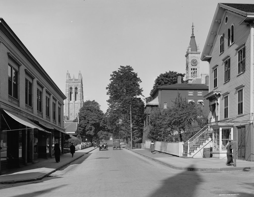
Rock Street from Pine Street, Fall River, Mass

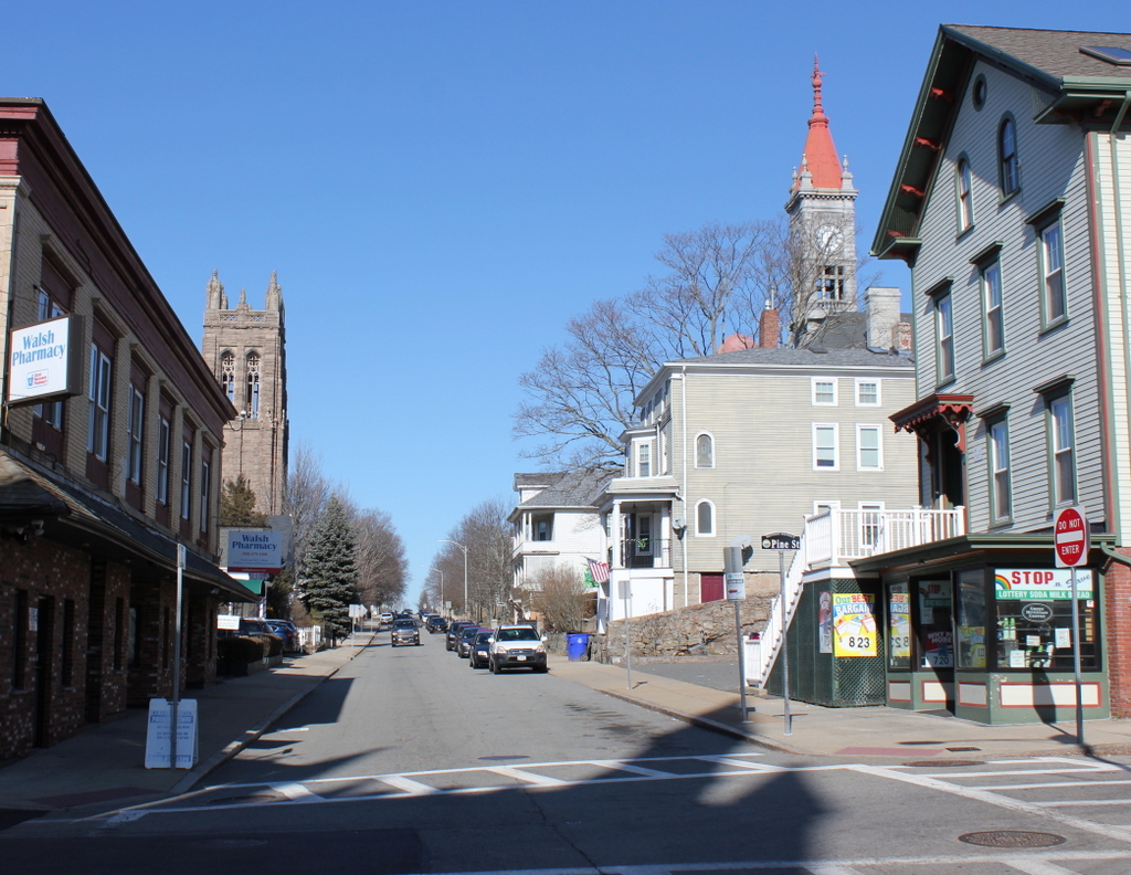
Looking north on Rock Street from the corner of Pine Street in Fall River, around 1913-1920. Image courtesy of the Library of Congress, Detroit Publishing Company Collection.

The scene in 2020:

The first photo shows a street scene in Fall River with an interesting assortment of commercial storefronts, single-family homes, and multi-family homes, along with a church and a school. The buildings also vary widely in age; some date back to the 1840s, while others were built just a few years before the photo was taken. Remarkably, though, all of the buildings from the first photo are still standing today, and this scene does not look substantially different from its appearance more than a century ago.

The city of Fall River developed into a major textile manufacturing center during the early 19th century, and some of the oldest buildings in this scene were built during that time. In the distance, on the left side of the street, is a group of four houses, located at 222, 232, 242, and 254 Rock Street. The oldest of these, number 222, is hidden from view by the building in the foreground, but it was built around 1815. Just beyond it, and also hidden here, is number 232, built around 1848. Both of these buildings have had significant exterior alterations, but the two that are visible in the distance of this scene, at 242 and 254 Rock Street, were built in the mid-1840s and have remained well-preserved over the years. In particular, 254 Rock Street survives as an excellent example of Carpenter Gothic architecture.

On the right side of the street, the oldest building here is at 223 Rock Street, which is the three-story building just beneath the clock tower. It was built around 1845, but it was originally located at 151 Rock Street. It was moved to its current location in 1913, so its presence here in the first photo establishes the earliest possible date for the photo.

Closer to the foreground, on the far right side of the scene, is 201-203 Rock Street. It was built around 1861, and its original owner was Albert Winslow, a former New Bedford whaling ship captain who retired to Fall River. According to the 1861 city directory he ran a grocery store here at the house, presumably in the basement storefront, and the 1870 census shows him living here with his wife Permela, their five children, and his sister Rowena. By 1900 both Albert and Permela were still living here, as were their three daughters: Hope, Amelia, and Ella. Permela died in 1902, and Albert in 1908, but the three sisters were still here when the first photo was taken. They evidently rented a portion of the house, because both the 1910 and 1920 censuses show a second family living here.

Until the late 19th century, this section of Rock Street primarily consisted of small wood-frame houses. However, in 1886 the city constructed the B.M.C. Durfee High School a block to the north of here. Most of the building is hidden from view in this scene, but its prominent clock tower is visible in the distance on the right side of the photos.  Another major addition to this scene is the First Congregational Church, which stands opposite the high school building in the distance on the left side of Rock Street. The church was designed by the prominent architectural firm of Shepley, Rutan & Coolidge, and it was dedicated in January 1913, probably only a few years before the first photo was taken. Aside from the school and church, the other new building in the first photo was the Gee Building, the two-story commercial building in the foreground on the left side. It was built in 1910, at the northeast corner of Rock and Pine Streets.

Today, more than a century after the first photo was taken, some of the buildings here have undergone changes, but overall this section of Rock Street remains well-preserved. In the foreground, probably the most visible difference is the ground floor of the Gee Building, which has been completely altered from its early 20th century appearance. The storefront on the Winslow house across the street has also changed, but not to the same extent. Further in the distance, both the church and the high school are still standing, although the high school has since been converted into a probate and family courthouse. The only building in this scene that was constructed after the first photo was taken is the house in the distance at 253-255 Rock Street, which was built in 1923. Because of their preservation and historic significance, all of the buildings on this block of Rock Street are now part of the Lower Highlands Historic District, which was added to the National Register of Historic Places in 1984.

Franklin and Armfield Office, Alexandria, Virginia

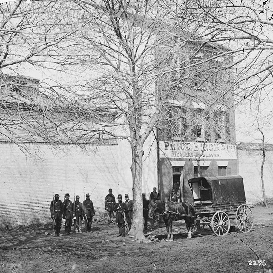
The Franklin and Armfield Office at 1315 Duke Street in Alexandria, around the early 1860s. Image courtesy of the Library of Congress, Civil War Collection.

The scene in 2021:

The Franklin and Armfield Office at 1315 Duke Street in Alexandria, Virginia was built in 1810. It was originally built as a private residence for Brigadier General Robert Young of the Second Militia of the District of Columbia, but he was forced to sell the home in 1820 due to financial problems. By 1828, the home was leased, and eventually bought by infamous slave traders, Isaac Franklin and John Armfield. Franklin and Armfield were the largest slave traders in the United States between 1828 and 1836, and the Duke Street home was turned into their main office.

Since the transatlantic slave trade was banned in 1808, Franklin and Armfield would send agents across Virginia, Maryland, and Delaware in search of slave owners who were willing to part with their slaves for relatively cheap prices. The enslaved people would then be shipped back and held in the high-walled courtyards surrounding the offices (Seen to the left and right of the house in the top picture). In these courtyards, the enslaved people were subject to brutal beatings, rapes, and countless other forms of cruel control. Rapes were so frequently done by Franklin and Armfield to their slaves, that they bragged about them in letters between each other, and both men would father children to enslaved women in their captivity. Franklin would later go on to sell the woman he raped and the child he fathered with her. A two-story extension was added to the back of the building to serve as jail cells. These cells could be used to isolate certain slaves but were more often rented out by travelling slave owners who wanted to keep their slaves on the Virginia side of the Potomac.

Due to a surplus of enslaved people in the Upper South, slaves did not fetch high prices in Alexandra. The enslaved people were typically kept in the home’s courtyards until enough of them were bought for them to all be shipped together or marched to their offices in Natchez and New Orleans. Once in the Deep South, they could be sold at much higher prices than they were bought for in Virginia. It’s estimated that Franklin and Armfield sold between 1,000-2,000 people each year, transporting all of them by way of cramped slave ships or forced marches across the South.
By 1836, Franklin decided to retire, and his partner Armfield decided to sell off most of the business. He sold the Duke Street offices to another slave trader, George Kephart. He would continue the practice of selling slaves until he sold it to yet another slave trading firm, Price, Birch & Co. in 1858.

Price, Birch & Co. would become infamous not for their volume of slaves sold, but rather for one particular man that they enslaved. Solomon Northup, a freed slave from Saratoga Springs, New York was kidnapped in Washington, DC in 1841. He was shipped down to New Orleans where we was bought by a planter and re-enslaved. It would take Solomon 12 years before he would once again gain his freedom with the help of Samuel Bass. A Canadian working on the plantation, Samuel was able to get word back to New York about Solomon’s re-enslavement. After an appeal to the Governor of New York, Solomon was granted his freedom in 1853. Solomon would later go on to write his famous memoirs, 12 Years a Slave. In his memoirs, Solomon named his kidnapper as “Burch”, but it’s largely been accepted that the man he was talking about was James H. Birch, of Price, Birch & Co. in Alexandria. It should be noted though that Solomon Northup does not appear to have actually passed through the Alexandria slave pens, only that Birch used the building as his offices. Price, Birch & Co. would go on to own the building until the Civil War, when it was occupied by Union Forces in 1861. During the Civil War the slave pens were ironically, used as jail cells for captured Confederate soldiers.

After the Civil War, a railroader by the name of Thomas Swann bought the property in 1870 and tore down the slave pen extension. The buildings exterior also underwent changes that give it its modern appearance, such as the fourth story windows being added as well as the arches over the windows on the front façade. The property changed hands multiple times over the last century, serving as apartments for most of that time before being sold in 2017 to the Northern Virginia Urban League. Today, the building has been re-named the Freedom House, and features a museum to the building’s history on the first floor, and offices for the Northern Virginia Urban League on the upper floors.

Marshall House, Alexandria, Virginia

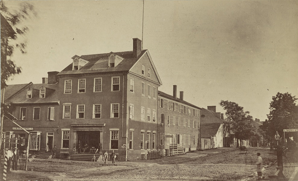
The Marshall House at the corner of King and Pitt Streets in Alexandria, around 1861-1865. Image courtesy of the Library of Congress, Civil War Collection.

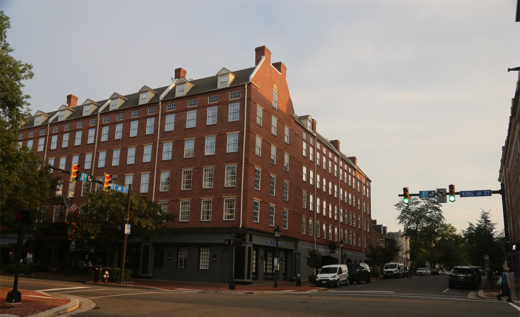
The scene in 2021:

The Marshall House in Alexandria, VA was built in 1799, originally as a tavern and inn called the Washington Tavern. Some time around the mid-1820s, the name of the tavern and inn was changed to the Marshall House, and by the eve of the Civil War it had become a popular meeting spot for secessionists. One of these secessionists was the recently hired manager of the Marshall House, James W Jackson. Jackson was a fiery secessionist, and months before the firing on Fort Sumter, decided to raise a massive, 18 foot wide Confederate flag up the flagpole that stood at the top of the Marshall House. The flag was so large and conspicuous, that it was reported to have been able to be seen with a spyglass from Washington, DC. To protect his flag, Jackson borrowed a ceremonial cannon from his neighbor and placed it in the backyard of the tavern facing the front door. Exclaiming that the flag would be removed over his dead body, his words would end up becoming perfectly prophetic.

May 24, 1861 marked the day that the Union Army began their advance across the Potomac river into Virginia. Colonel Elmer E. Ellsworth, close friend of President Lincoln and commander of the famous New York Fire Zouaves (11th New York Infantry), was tasked with cutting telegraph wires leading out of Alexandria. As Ellsworth marched past the Marshall House though, he felt it was his sole duty to first remove the flag of secession from the top of the tavern. Taking Private Francis E. Brownell with him, Ellsworth managed to make his way up to the roof of the tavern and remove the flag. On their descent though, they were surprised by Jackson pointing a double-barreled shotgun at Ellsworth. Jackson immediately shot Ellsworth in the chest, killing him instantly. Simultaneously, Private Brownell shot Jackson in the face and bayoneted him, killing him instantly as well. This incident at the Marshall House would mark the first Union officer to die in the Civil War. Ellsworth’s body would be sent to the White House for public mourning, while Jackson’s actions made Southerners view him as their first martyr of the war.

During and after the war the Marshall House attracted many tourists, soldiers and civilians alike. Many took souvenirs of the carpet, floorboards, or the outside signage. In 1873 most of the tavern burned down by an arsonist. Only the brick exterior remained after the fire. The building was restored after the fire, although with many Victorian style decorations added to the exterior. By the time the Marshall House was razed in the 1950s for downtown development, it resembled little of how it did during the Civil War.

Fittingly enough, the spot where the Marshall House was is today a hotel. The latest iteration of the site is The Alexandrian Hotel, owned by Marriott Bonvoy. Nothing currently marks the spot where Ellsworth and Jackson died, although up until recently there was a plaque on the side of the hotel posted by the Sons of Confederate Veterans that read:

THE MARSHALL HOUSE
stood upon this site, and within the building
on the early morning of May 24,
JAMES W. JACKSON
was killed by federal soldiers while defending his property and
personal rights as stated in the verdict of the coroners jury.
He was
the first martyr to the cause of Southern Independence.
The justice of history does not permit his name to be forgotten.

Not in the excitement of battle, but coolly and for a great principle,
he laid down his life, an example to all, in defence of his home and
the sacred soil of his native state.
VIRGINIA

Marriott Bonvoy seems to have quietly removed the plaque after pushback from the community.

Interestingly, the Marshall House also played a much smaller role in the Civil War. In 1859, the tavern issued tokens with an image of Minerva in profile on them. Tokens from private businesses were common before the war in both the North and the South. People hoarded metal coinage, believing their value would go up once war started. To counteract this, many businesses made their own tokens made from less valuable metals to help stimulate commerce. The tokens from the Marshall House eventually made their way down to Richmond, where the engraver Robert Lovett, Jr. used its image of Minerva as an exact model for his Confederate cent prototypes.

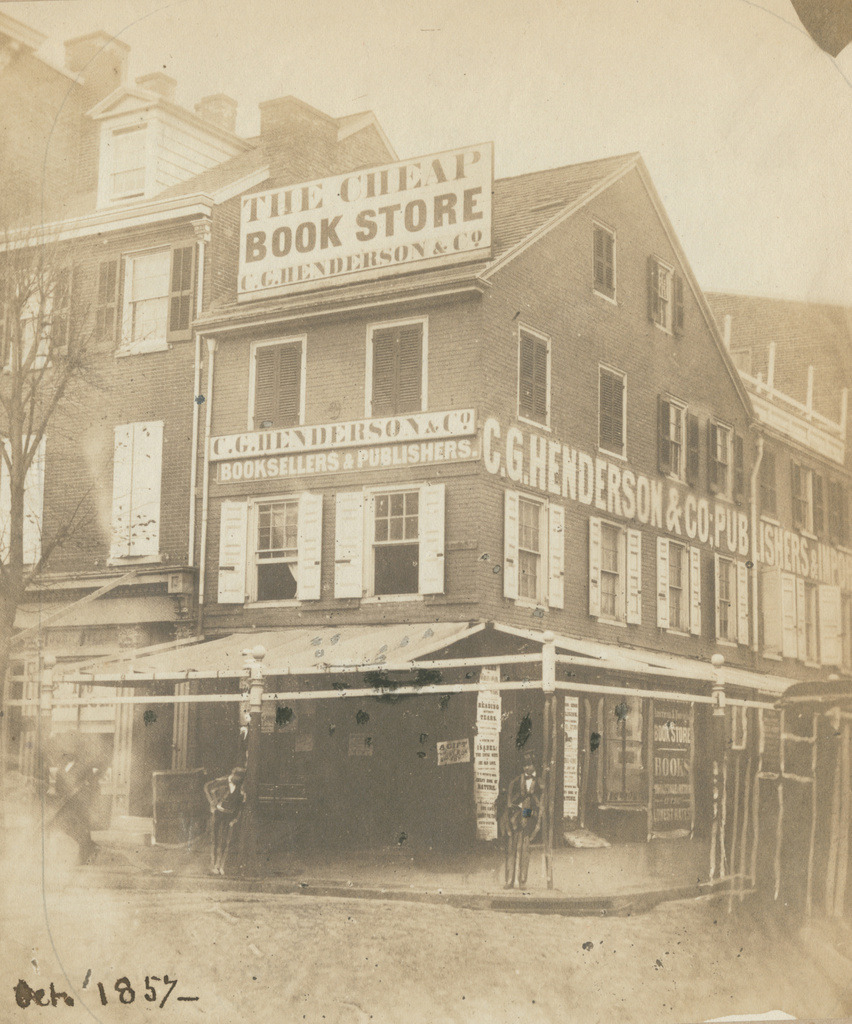
Corner of Fifth and Arch Streets, Philadelphia, Pennsylvania

The northwest corner of Fifth and Arch Streets in Philadelphia, in October 1857. Image courtesy of the Library Company of Philadelphia, Frederick De Bourg Richards Photograph Collection.

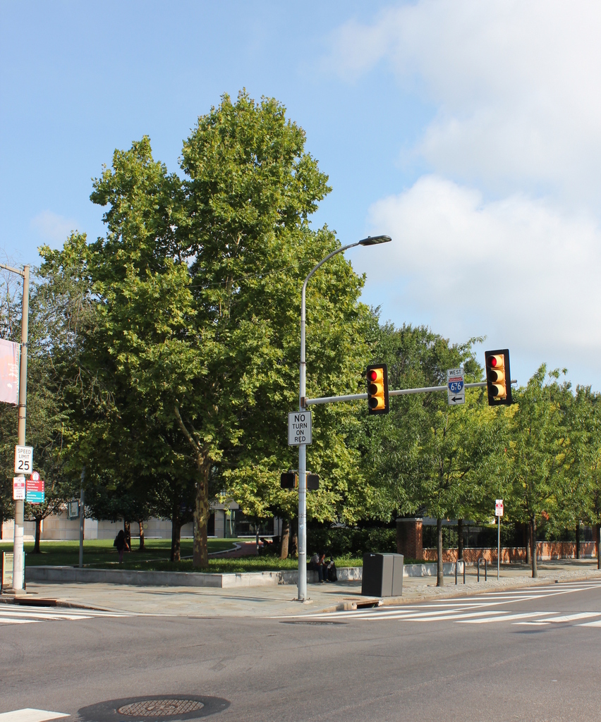
The scene in 2019:

The first photo was taken by photographer Frederick De Bourg Richards, as part of an effort to document Philadelphia’s historic 18th and early 19th century buildings. Unlike many of Richards’s other subjects, such as the Free Quaker Meeting House across the street from here, this three-story commercial building does not appear to have been a major historic landmark. In the original caption of the photo, the building is described simply as “a primitive house,” with no further information as to its history or date of construction. However, it was likely built sometime in the 1700s, and it may have once served as a single-family home before being converted into commercial use.

By the time the first photo was taken, the building was occupied by the publishing and bookselling firm of C. G. Henderson & Co. The company had been established in 1851, and was originally located in a building at the corner of Seventh and Chestnut Streets. However, that building burned later in the year, and by 1852 C. G. Henderson was located here at the corner of Fifth and Arch. As shown in the first photo, the building featured a number of exterior advertisements, including a particularly large sign on the roof, proclaiming it to be “The Cheap Book Store.”

The bookstore seems to have closed within a year or two after the first photo was taken, but the fate of the building itself is somewhat less clear. It may have been demolished at some point in the late 19th century, but it was definitely gone by the mid-20th century, when this entire block, along with several others, was leveled to create the Independence Mall. Today, there are no surviving remnants from the first photo in this scene. Instead, the foreground here is open parkland, and further in the distance is the National Constitution, which occupies much of this block.

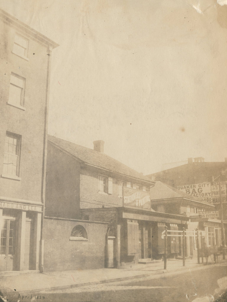
Friends’ Academy, Philadelphia, Pennsylvania

The former Friends’ Academy building on the east side of Fourth Street, just south of Chestnut Street in Philadelphia, in April 1859. Image courtesy of the Library Company of Philadelphia, Frederick De Bourg Richards Photograph Collection.

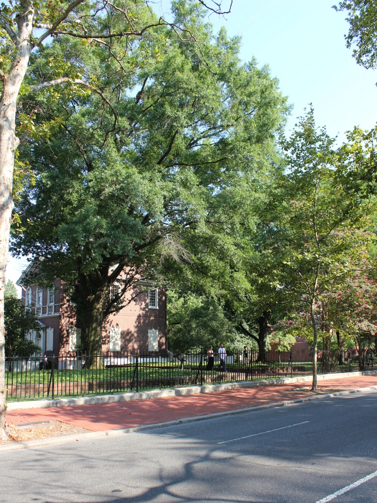
The scene in 2019:

Philadelphia is famous for its association with Quakers, having been founded by Quaker leader William Penn. The Quakers had a number of meeting houses throughout the city, during the colonial period along with several schools, including the Friends’ Academy here on Fourth Street. Both of the buildings in the first photo were built by the Quakers in the mid-18th century, although it seems unclear as to whether both were schools, or if one was a school and one was a meeting house.

The origins of the Friends’ Academy traces back to 1689, when it was established at the behest of William Penn. It moved to this location in 1744, and remained here for nearly a century, until 1841. During this time it was one of the city’s leading schools, and it also had several prominent schoolmasters, including abolitionist Anthony Benezet and historian Robert Proud.

The school relocated to Eleventh Street in the fall of 1841, and eventually became the William Penn Charter School, which still exists as a Quaker-affiliated independent school. In the meantime, though, its former home here on Fourth Street became a mathematical school during the 1840s, run first by William J. Lewis and then by Clinton Gillingham. This school appears to have closed around 1849, and at some point both buildings here were converted into commercial use, with one-story storefront additions extending to the sidewalk, as shown in the first photo.

Up until shortly before that photo was taken, these buildings were occupied by a stationery and printing business on the left, and a gas fitter further in the distance on the right. However, by the time the photo was taken in April 1859, the buildings were boarded up in preparation for demolition, which occurred soon after. They were replaced by more modern commercial buildings that have, in turn, been demolished as well, and today the site is part of the Independence National Historical Park.

Today, there are no surviving features from the first photo, although Carpenters’ Hall stands on the left side of the present-day photo. Built in the early 1770s and made famous as the meeting place of the First Continental Congress, this building was standing when the first photo was taken, but it was not visible from this section of Fourth Street until the rest of the block was demolished around the mid-20th century.

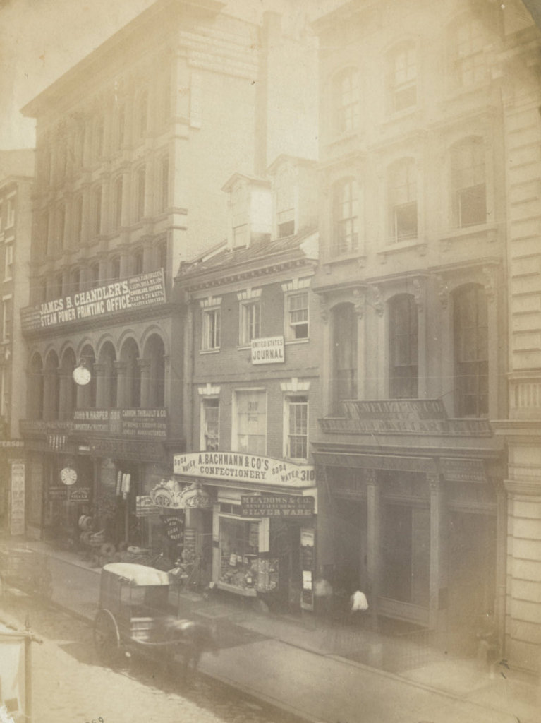
Zachariah Poulson House, Philadelphia, Pennsylvania

The former home of Zechariah Poulson, at 310 Chestnut Street in Philadelphia, in May 1859. Image courtesy of the Library Company of Philadelphia, Frederick De Bourg Richards Photograph Collection.

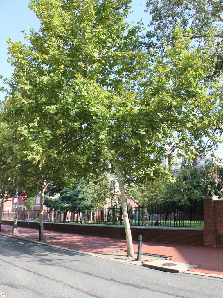
The scene in 2019:

The house in the center of the first photo was probably built sometime in the late 18th century, and for many years it was the home and office of publisher Zechariah Poulson. Born in Philadelphia in 1761, Poulson grew up during the turmoil of the American Revolution and learned the printer’s trade. He subsequently went into business for himself, and became a successful printer. By the late 1790s he was living here on Chestnut Street and publishing books and other materials, and then in 1800 he purchased the Claypoole’s American Daily Advertiser newspaper, which he renamed Poulson’s American Daily Advertiser. He went on to publish it for nearly 40 years, before selling it in 1839, and he appears to have lived here until his death five years later.

The Poulson family still owned the house when the first photo was taken in 1859, but by this point the old house was surrounded by taller, modern commercial blocks. As indicated by the signs on the front of the house, it was occupied by several different commercial tenants. On the ground floor was A. Bachmann & Co. Confectionery, and the building also features signs for Meadows & Co. silverware manufacturers and the United States Journal.

The buildings on either side of the former Poulson house also have a variety of signage in the first photo, including a printing office, a jewelry manufacturer, a watch importer, and a commission merchant. However, the most interesting is the sign above the storefront just to the left of the Poulson house, at 308 Chestnut Street. This was the home of Goodyear’s Rubber Packing & Belting Company, which was operated by Charles Goodyear, the developer of vulcanized rubber. Goodyear died a year after this photo was taken, and his business was unrelated to the more famous Goodyear Tire and Rubber Company, which was named after him in 1898.

Today, more than 160 years after the first photo was taken, there are no surviving remnants from the photo in this scene. The Poulson house was probably demolished at some point in the 1860s, because by the early 1870s it was occupied by the new Union Banking Company building. This building, along with the others in the first photo, have also since been demolished, perhaps as late as the mid-20th century, when nearly the entire block was cleared in order to open up space for the Independence National Historical Park. Only a handful of 18th century buildings survived, including the First Bank of the United States building, which is visible in the distance on the far right side of the present-day scene.