Charles Street Meeting House, Boston (1)

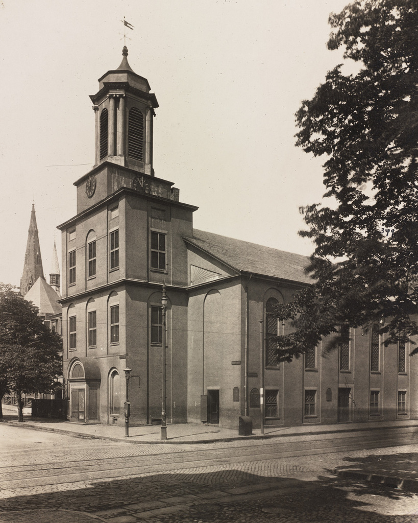
The Charles Street Meeting House, at the corner of Charles and Mt. Vernon Streets in Boston, around 1889. Image courtesy of the Boston Public Library.
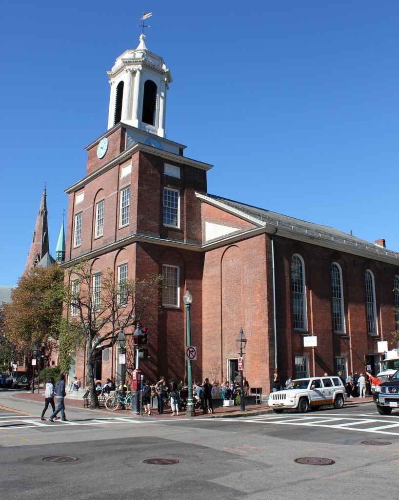
813_1889c bpl

The church in 2015:

813_2015
This historic church in the Beacon Hill neighborhood was built in 1807 as the Third Baptist Church. It was designed by Asher Benjamin, a New England native who was one of the leading American architects of the Federal era, and at the time it was located right along the waterfront. The building hasn’t moved in the past two centuries, but the shoreline has; Charles Street once ran along the Charles River at the western edge of the city, but after widespread landfill projects in the 19th century the church is now a considerable distance from the water.

Prior to the Civil War, this church was prominent in Boston’s abolitionist movement, and it hosted speakers such as Frederick Douglass, Wendell Phillips, Charles Sumner, and Sojourner Truth. After the war, though, the congregation declined, and merged with the First Baptist Church by 1876. The building was sold to the First African Methodist Episcopal Church, and became the Charles Street A.M.E. Church.

When the first photo was taken around 1889, the A.M.E. Church still owned it, and they remained here until 1939. By then, Boston’s black population had shifted away from its historic roots in Beacon Hill, and the congregation relocated to Roxbury. The building was later used as an Albanian Orthodox church and later as a Unitarian Universalist church until the late 1970s. A few years later, it was converted into offices. The interior was completely renovated, but the exterior was preserved, and today it is a part of the National Park Service’s Boston African American National Historic Site.

Newbury Street, Boston

Looking west on Newbury Street from Arlington Street in Boston, around 1880. Image courtesy of the Boston Public Library.

806_1880c bpl

Newbury Street in 2015:

806_2015
Like the rest of the Back Bay, Newbury Street was originally developed as an upscale residential street, starting in the early 1860s. The oldest building on the street is the Emmanuel Episcopal Church, which was completed in 1861 as one of the first of many churches that would eventually relocate to the Back Bay. It is partially visible on the right side, just to the right of the steeple of another historic church, the Central Congregational Church, which was built a block away at Berkeley Street in 1867.

Aside from these two churches, the rest of the buildings in the first photo are residential brownstones, similar to those found throughout the rest of the Back Bay. However, beginning in the early 1900s, the street began to transition into an upscale shopping district. Further down the street, many of the historic houses were converted into stores, but the Arlington Street end has seen some significant changes. This is generally where most of the high-end shops are located, and the 2015 photo includes companies like Burberry, Chanel, and Tiffany in the foreground. The Burberry building, located at the corner on the far left, is original from the first photo, and just beyond the Emmanuel Church there is a group of brownstones, but otherwise most of the other houses from the first photo have either been demolished or altered beyond recognition.

George Washington Statue, Public Garden, Boston

The side view of the George Washington statue in the Boston Public Garden, facing north toward Beacon Street, sometime in the 1800s. Image courtesy of the Boston Public Library.

802_1800sc bpl

The statue in 2021:

As mentioned in this earlier post, this statue of George Washington has stood at the Commonwealth Avenue entrance to the Public Garden since 1869. It was designed by sculptor Thomas Ball, a Boston native who also designed the Charles Sumner statue in the Public Garden, and the Emancipation Memorial at nearby Park Square. Since then, not much has changed about the statue or the surrounding park. The trees now obscure the view of the houses in the distance, but many of them are still standing today, along Arlington Street to the left and Beacon Street in the center and right.

Public Garden Lake, Boston

Looking west across the lake in the Boston Public Garden, sometime in the late 1800s. Image courtesy of the Boston Public Library.

800_1877-1910c bpl

The view in 2015:

800_2015
Boston’s Public Garden, as mentioned in this post, was the first public botanical garden in the United States when it was established in 1837. It was located along the edge of the city’s original shoreline, and like the rest of the Back Bay it was a tidal marsh when European settlers first arrived in 1630. By the 1850s, though, the city was looking to expand west by filling in the Back Bay, and one of the initial projects was the landscaping of the Public Garden, which was done in the early 1860s by landscape architect George Meacham.

In the years since the first photo was taken, the Public Garden itself hasn’t changed much. It still has the artificial lake in the center, surrounded by walkways, flower beds, and statues. The lake’s famous swan boats are not visible here, but they began operation in 1877 and are still in use during the summer months. Also not visible from here is the bridge over the lake, which was added in 1867 a little to the right of this scene, and is still there today.

The greatest difference between these two photos, obviously, is the skyline beyond the Public Garden. When the first photo was taken, the eastern portion of the Back Bay had been developed, and the Arlington Street Church, built in 1861, was the most obvious landmark in this scene. The church is still standing, as are the townhouses just to the right of it along Arlington Street, but otherwise all of the other buildings from the first photo are gone. The buildings to the left of the church are on Boylston Street, and most of the Victorian townhouses were demolished long ago as the street became an important commercial area. In the distance, skyscrapers such as the old and new John Hancock buildings and the Prudential Tower show how the southern section of the Back Bay has been extensively redeveloped starting in the second half of the 20th century.

Collins House and Livery Stable, Wilbraham, Mass

The Warren Collins home and livery stables, on Boston Road in North Wilbraham, possibly around 1872. Image courtesy of the Wilbraham Public Library.

743_1872c wpl

The scene in 2015:

743_2015
These buildings can be seen in the distance of the c.1900 photo in the previous post, which explains the history of the Collins Inn that once stood nearby.  This location was directly across the street from Wilbraham’s only railroad station, and it was from here that Warren L. Collins operated a stagecoach line to the center of town, two miles away.  The livery stables in the background were probably used to house the horses for this line.  Given the nature of livery stables, it probably would have also been used to care for the horses of the inn’s guests.

The one thing that is in question about this photo is the date. A copy of this image can be found online here, which is where the 1872 date comes from.  However, that date might be a little too early; the 1873 atlas of Hampden County includes an inset map of North Wilbraham, which was labeled as Collins Depot.  Neither of these buildings appear on the map, and a different building on the other side of the street is labeled as the livery stables.  Additionally, the Collins Inn was not built until 1874, and the 1964 History of Wilbraham book suggests that Collins built this livery stable at some point after opening the inn.  So, it seems more likely that the photo was taken either a little later in the decade or maybe in the 1880s.

Either way, there is not much left from the old photo.  Both the stables and the small house in the foreground are gone, but the basic business model is still going on here today.  Instead of feeding and caring for horses, the present-day business performs a very similar function, providing fuel and repairs for cars.  There also appears to be at least one surviving element from the original photo; the building on the far left looks like it is the same one that was standing there.

Portland Head Light, Cape Elizabeth, Maine (3)

Another view of Portland Head Light, probably taken around the 1870s. Image courtesy of the New York Public Library.

741_1865-1883c nypl

The lighthouse in 2015:

741_2015
The first photo here was probably taken around 10-20 years before the ones in the previous two posts here and here, and it shows the tower as it appeared following its 1865 height change.  As mentioned in more detail in the first post, the lighthouse was built in 1791, but was reduced in height by 20 feet in 1812, to the spot below the lantern where a horizontal band runs around the tower.  Those 20 feet were restored in 1865, as seen in the first photo, but the tower was trimmed down again in 1883.  Just two years later, though, enough sailors complained that it was raised 20 feet yet again, with changes such as a larger lantern room at the top and  a second gallery below it.  Since 1885, it hasn’t seen very many changes, and it remains an active lighthouse as well as a popular tourist destination along the southern coast of Maine.