South Street, Pittsfield, Mass

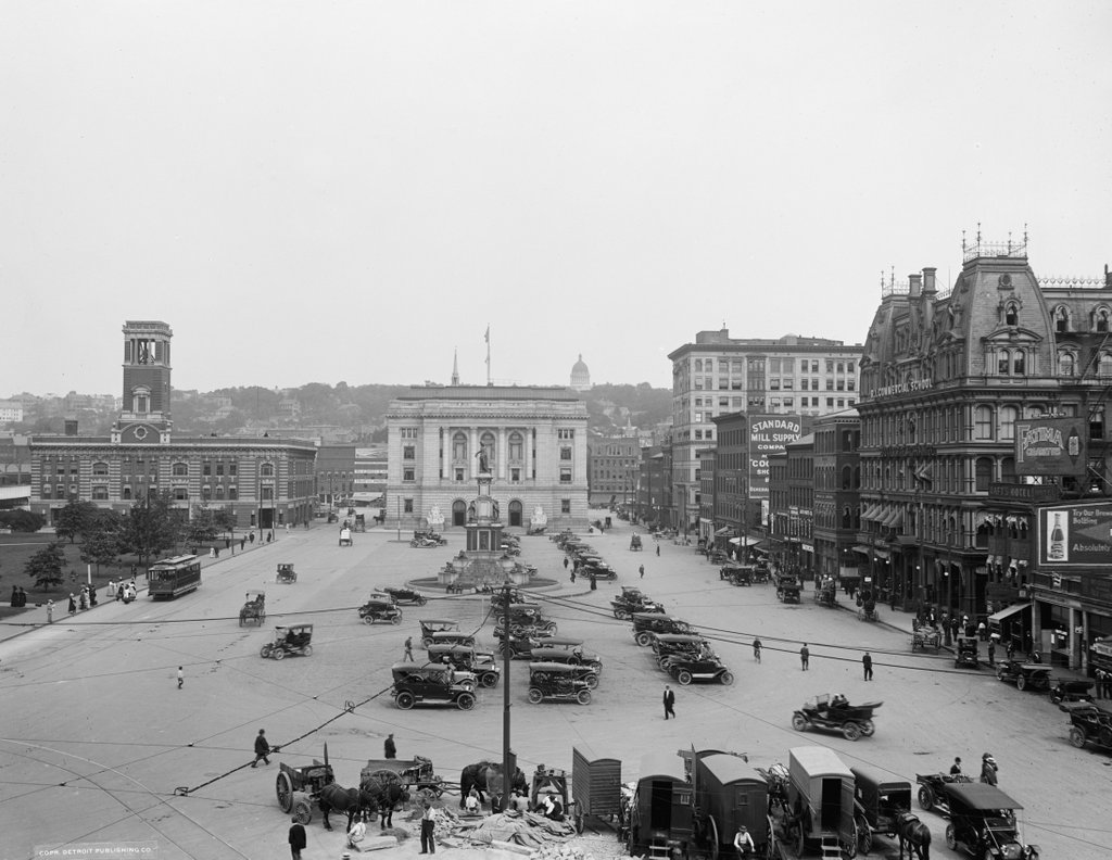
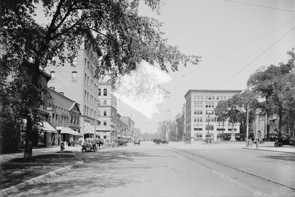
Looking north on South Street in Pittsfield, toward Park Square, around 1911-1915. Image courtesy of the Library of Congress, Detroit Publishing Company Collection.
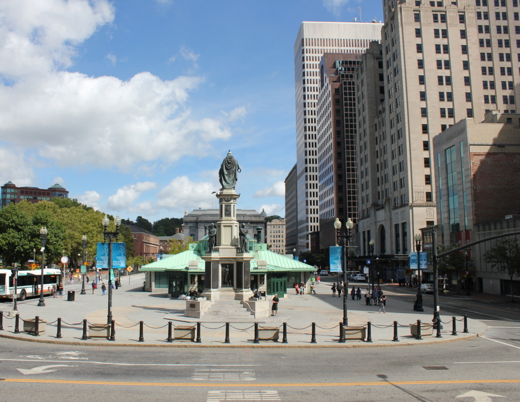
1094_1900-1915-loc

The scene in 2016:

1094_2016
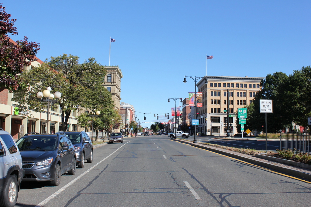
Although a century has passed since the first photo was taken, the appearance of downtown Pittsfield has not significantly changed. The buildings in this scene are built around Park Square, which is partially visible on the right side and is the main focal point in the center of the city. Looking ahead in the distance is North Street, which is lined with 19th and early 20th century commercial blocks.

Pittsfield is the largest city in the Berkshires, and when the first photo was taken the region was a resort destination for wealthy families across the northeast, especially from New York. As a result, Pittsfield thrived, and the first photo shows a number of prominent buildings in the foreground.

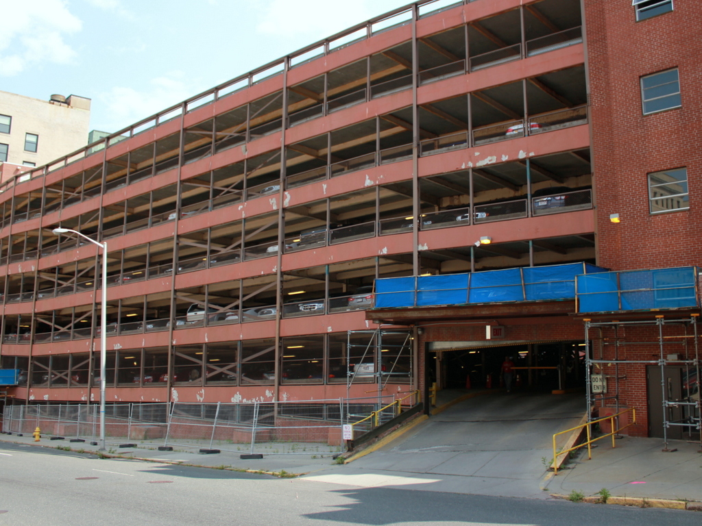
To the left was the Hotel Wendell, which was built in 1898 at the corner of South and West Streets. It was the city’s premier hotel in the first half of the 20th century, and in 1930 it was expanded, replacing the much smaller buildings on the far left. Within a few decades, though, times had changed for grand downtown hotels across the country, and in the 1960s the hotel closed and was demolished.

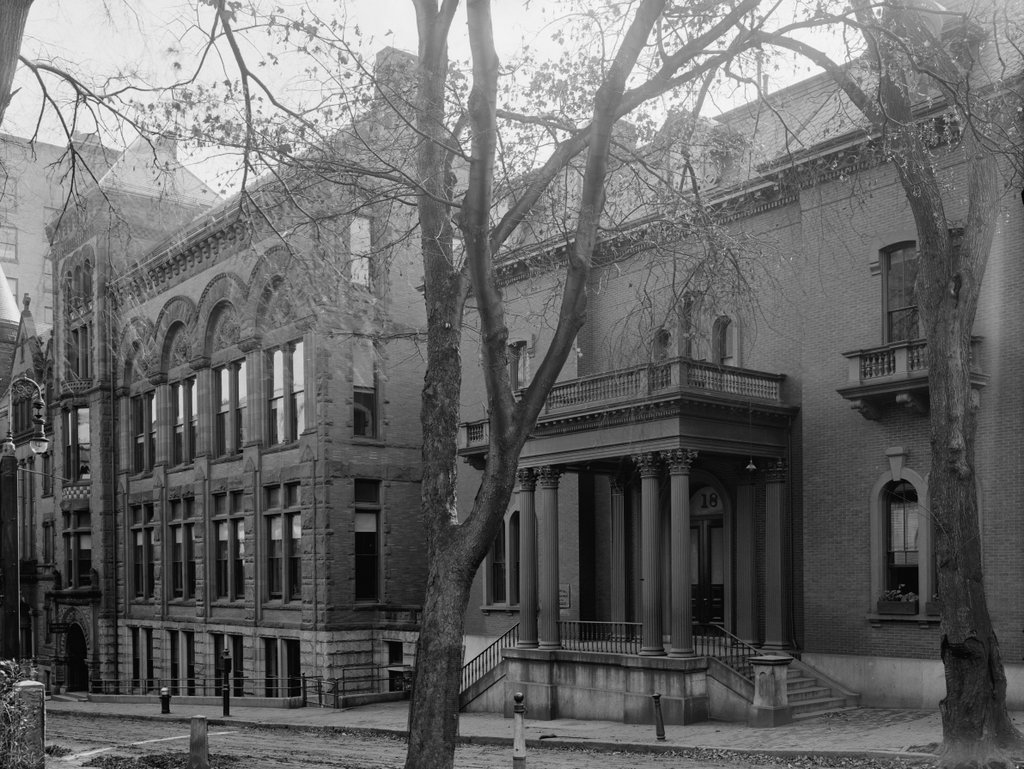
Just beyond the Hotel Wendell, at the corner of North and West Streets, is the Berkshire Life Insurance Company Building. Constructed in 1868, it was significantly expanded in 1911, shortly before the first photo was taken. It is still standing today, along with the Berkshire County Savings Bank Building, which was built in 1896 across the street on the right side of the photo. Both of these buildings are now part of the Park Square Historic District on the National Register of Historic Places.

Exchange Plaza, Providence, RI

Looking east toward Exchange Plaza from City Hall in Providence, around 1913-1920. Image courtesy of the Library of Congress, Detroit Publishing Company Collection.

1084_1900-1920-loc

The scene in 2016:

1084_2016
Exchange Plaza has been at the center of downtown Providence since the 19th century, although both it and its surroundings have undergone many changes during this time. In 1847, the city’s first railroad station was built here on the north side of the plaza. A new station was built a little further to the north in 1898, and City Hall Park opened on the site of the old station, on the left side of both photos. City Hall, where these photos were taken, was built on the west side of the plaza in 1878, across from the Soldiers’ and Sailors’ Monument. This statue was dedicated in 1871 and moved to the center of the plaza shortly before the first photo was taken, but was moved back to its original location in 1997.

The first photo shows a variety of transportation methods, including cars, trolleys, and horse-drawn carts. However, at this point cars had begun to dominate the city streets already, and Exchange Plaza had become a parking lot. On the opposite side of the plaza in both photos is the Federal Building, which was built in 1908 as a post office, courthouse, and custom house. It is still in use today, and is one of only a few buildings still standing here from the first photo.

The right side of the plaza, which was renamed Kennedy Plaza in 1964, is now dominated by skyscrapers. In the first photo, the most prominent building here was the Butler Exchange, a six-story commercial block on the far right. It stood here from 1873 to 1925, and after its demolition it was replaced by the present-day 111 Westminster Street building. Completed in 1928, this 26-story skyscraper remains the tallest building in Rhode Island nearly 90 years later.

Today, the only building still standing from the right side of the first photo is the Exchange Bank Building, barely visible in the distance at the corner of Exchange Street, diagonally across from the Federal Building. Completed in 1845, it predates even the original railroad station that stood opposite the plaza. However, it is not the oldest building in the scene. That distinction likely goes to the First Baptist Church in America, which was built in 1775 on the other side of the Providence River. The top of its spire is visible in both photos, behind the Federal Building.

John Hay Library, Brown University, Providence, RI

The John Hay Library at the corner of Prospect and College Streets in Providence, around 1910-1920. Image courtesy of the Library of Congress, Detroit Publishing Company Collection.

1067_1910-1920-loc

The library in 2016:

1067_2016
The John Hay Library is one of several libraries at Brown University. The building was designed by the prominent Boston architectural firm of Shepley, Rutan & Coolidge, and opened in 1910 as the school’s primary library. It was built in part with funds from Andrew Carnegie, and is named for John Hay, an 1858 graduate of Brown who had served as US Secretary of State from 1898 until his death in 1905.

It remained in use as main library until 1964, when the John D. Rockefeller, Jr. Library opened just to the left of here, on the other side of College Street. Today, the John Hay Library is used to house the special collections, rare books, and the University Archives. Among its more unusual holdings are several anthropodermic books, which are books bound in human skin. The library also has an extensive collection of letters and other manuscripts from horror writer H.P. Lovecraft, a Providence native who lived nearby and often visited the library.

View from Citadel Hill, Halifax, Nova Scotia

The view looking east toward downtown Halifax from Citadel Hill, around 1900-1917. Image courtesy of the Library of Congress.

1056_1900-1917c-loc

The view in 2016:

1056_2016
It isn’t in New England, or even in the United States, but Halifax has long had close ties with New England, especially Boston. It is the closest major North American port to Europe, and as such it is the last stop for outgoing ships from Boston, and the first for incoming ships. This scene here shows part of the city’s massive harbor, which has been of strategic importance over the years. After the British occupation of Boston ended in 1776, their fleet took refuge here in Halifax while preparing for an assault on New York City, and many years later the harbor was used as a gathering place for eastbound Atlantic convoys in both world wars.

Through all of this, the strategically-valuable harbor has been protected by Fort George, a series of fortifications atop Citadel Hill. The hill stands just west of downtown Halifax, offering sweeping views of the city and harbor, and making it the ideal location for a fort to command the harbor and its approaches. The photos here were taken near the top of the hill, near the outer walls of the fort. On the left is one of Halifax’s oldest landmarks, the Town Clock, which was built at the foot of the hill. It faces down Carmichael Street, which leads to the Grand Parade three blocks down the hill, where City Hall and St. Paul’s Anglican Church are located.

The date of the first photo is somewhat unclear, but it was taken sometime soon before 1917, when Halifax experienced one of the deadliest disasters in history. Known as the Halifax Explosion, it occurred on December 6, 1917, when the harbor was filled with ships heading to and from Europe during World War I. Two such ships were the Norwegian SS Imo, which collided with French ammunition ship SS Mont-Blanc. The latter caught fire, and after about 20 minutes its cargo of high explosives detonated.

The Mont-Blanc was essentially vaporized, and the blast wave leveled much of the northern part of the city, to the left and out of view in the photos here. A few earlier posts, here and here, show scenes from the aftermath of the explosion, which killed nearly 2,000 people, injured around 9,000 others, and damaged or destroyed around 12,000 houses. The main commercial center of Halifax, seen in this view from Citadel Hill, escaped serious damage. Essentially every window in the city was shattered by the explosion, but most of the buildings in the first photo would have survived the disaster.

Despite being spared from serious damage, there is very little that is still recognizable from the first photo a century later. There are a number of 19th century buildings scattered throughout this section of the city, but the only one that is readily visible in both photos is the clock tower itself, which remains a prominent city landmark.

Today, Halifax remains an important port. It is the largest city in Canada’s Maritime provinces, and its downtown has been built up with skyscrapers, partially obscuring the view of the harbor from Citadel Hill. The shoreline across the harbor in Dartmouth has also changed dramatically in the past 100 years. In 1911, the community had a population of just over 5,000, but today it has over 67,000 people, and is a major suburb of Halifax as well as a commercial center in its own right.

First Congregational Church, West Springfield, Mass

The First Congregational Church on Park Street in West Springfield, around 1912. Image from Picturesque Springfield and West Springfield (1912).

1055_1912c-picturesquespfld

The church in 2016:

1055_2016
In the 18th and early 19th centuries, few issues caused as much controversy in some New England towns as the location of the meetinghouse. West Springfield experienced this in 1802, owing in part to its unusual geography. This area along the common has long been the social and commercial center of the town, but geographically it is located in the southeastern corner of the present-day borders. In the days when everyone in town was expected to attend the same church, this was an inconvenient location for the farmers who lived in the northern and western parts of the town, so when a new meetinghouse was proposed at the turn of the 19th century, it caused considerable debate.

The result was a compromise of sorts. Rather than favoring those in the town center or the farmers in the outskirts, a site was chosen that was equally inconvenient for all, on Elm Street opposite Kings Highway. Located nearly a mile north of the center, on a hill overlooking the Connecticut River, this meetinghouse was completed in 1802. Its construction costs were paid by John Ashley, a farmer in the northern part of the town who stipulated that the First Congregational Church needed to remain there for at least 100 years.

Hamstrung by Ashley’s conditions, the church could do little but count down the years, but nothing prevented town residents from forming a new church society, Park Street Congregational Church, which they established in 1870. Two years later, their brick Gothic-style church opened here on Park Street, providing a new, more elegant building in a prominent location for the residents of downtown West Springfield.

Architecturally, the new building was part of a trend in post-Civil War New England, which eschewed the more traditional plain white church buildings of previous generations. The actual design was copied from Springfield’s Church of the Unity, which had been completed three years earlier. The Church of the Unity was the first major commission of Henry Hobson Richardson, who later became one of the most influential American architects of the 19th century. His works inspired many imitations, perhaps the first of which was this church here in West Springfield. Although it hardly compares to the architectural grandeur of the Church of the Unity, this scaled-down brick copy shows the influence that, even as a young architect, Richardson’s works had on his contemporaries.

The Church of the Unity was demolished in the early 1960s and its site is now a parking lot opposite the Springfield Public Library, but the Park Street Congregational Church is still standing today, just with a different name. In 1909, with the century-old limitations now expired, the First Congregational Church was able to move from its old meetinghouse, and they merged with the Park Street church here in this building, where they remain today. The old 1802 meetinghouse, although no longer used as a church, is also still standing on Elm Street, providing West Springfield with two historic church buildings that represent two very different 19th century architectural styles.

Public Library, Worcester, Mass

The Worcester Public Library on Elm Street, around 1905-1915. Image courtesy of the Library of Congress, Detroit Publishing Company Collection.

1037_1905-1915-loc

The scene in 2016:

1037_2016
Prior to the mid-19th century, public libraries were almost unheard of in the United States. However, by the late 1850s many cities were establishing their own libraries, including Worcester in 1859. It began with about 10,000 books, donated from the Worcester Lyceum and the private collection of Dr. John Green, and was originally housed on the third floor of a commercial block at the corner of Main and Foster Streets.

In 1862, the library moved into its first permanent home on Elm Street, the building on the right side of the first photo. In the following decades, though, the library’s collections outgrew this original space, and in 1891 it was expanded to the east with the massive addition on the left side of the photo. This addition was designed by Worcester architect Stephen Earle, with a Romanesque style design that bore no relation to the more Italianate-based style of the original building.

The Worcester Public Library remained here until 1964, when it moved to its current location on Salem Street. The century-old building here on Elm Street, along with its 1891 addition, were then demolished, and the site was redeveloped as a parking garage.