Benjamin Daland House, Salem, Mass

The house at 23 Summer Street in Salem, around 1891. Image courtesy of the Phillips Library at the Peabody Essex Museum, Frank Cousins Collection of Glass Plate Negatives.

The house in 2019:

This house was built sometime between 1756 and 1760 by Benjamin Daland. He does not appear to have lived here for very long, though, because in 1760 he sold the property to Samuel Calley, who in turn sold it in 1762 to Captain George Dodge, a mariner from nearby Beverly. He was 35 years old at the time, and he and his wife Lydia and their seven children. They subsequently had two more children over the next new years, and Dodge owned the house until 1782. By this point Dodge was referred to in historical records as a merchant rather than a mariner, suggesting that he took the career path of many retired sea captains in Salem and went into business for himself as a merchant. Like many other Salem merchants, he was also involved in privateering during the American Revolution, owning several privateer ships that preyed on British shipping.

The next owner of the house was William Orne, who purchased it from Dodge in 1782 for 1,100 pounds. The historical records indicate that he was also a ship captain and later a merchant, but there appears to have been several William Ornes living in Salem during this period, so it seems difficult to determine which one owned this house. However, it may have been the same William Orne who was captured by the British during the War of 1812 and was being held prisoner aboard the HMS Guerriere during its famous battle with the USS Constitution.

Another area of uncertainty in tracing the history of this house is that, while Orne owned the house, it does not necessarily mean that he—or the other early owners of the house—personally lived here. In any case, though, Orne owned the house until 1807, when he sold it for $4,600 to Thorndike Deland, who then sold it for $4,500 in 1812 to his sister Eliza Osborn. Eliza was a wealthy widow whose husband, Captain George Osborn, had been swept overboard at sea in 1800. A year after acquiring this house she remarried to Abner Kneeland, a Unitarian theologian who would become a notable and controversial religious figure over the next few decades.

As with the previous owners, it does not seem clear how long Eliza actually lived here, because she and Abner only lived in Salem for a couple years after their marriage. However, the house would remain in her family for many years. It was owned jointly by George Osborn and Eliza Archer, her children from her first marriage, until 1863, when George became the sole owner. Neither sibling appears to have lived in the house, though, because city directories of the period list several other residents here, including grocer John Chamberlain, who was living in the house as early as 1846.

After George Osborn’s death in 1882, his daughter Eliza D. Shepard inherited the property. The first photo was taken about a decade later by Frank Cousins, a prominent photographer who documented historic buildings in Salem and other places in the northeast around the turn of the 20th century. Cousin’s caption identifies it as the “Doctor T.O. Shepard house,” indicating that Eliza Shepard’s son Thomas was living here at the time.

Thomas and his sister Sarah eventually acquired the house, and unlike some of the previous generations they definitely lived here on Summer Street. The 1910 census shows them living here together, unmarried and in their 40s. Thomas, who was an 1892 graduate of Harvard Medical School, was an oculist, and he had his practice here in the house. The Shepards also employed two live-in servants at the time, one of whom was listed as a cook in the census.

Thomas continued to live here until his death in 1935, and Sarah remained here for at least a few more years, but by the 1940 census she was living elsewhere. Then, in 1941 she sold this house on Summer Street to Marie Anne Cadorette. This marked the end of 135 years of ownership by the same family, which had spanned four different generations of Osborns and Shepards.

Today, well over a century after the first photo was taken, the house is still standing. It has seen some changes, including the loss of the shutters and the front entryway, and the outbuilding in the back of the lot is gone, but overall it survives as one of the many well-preserved historic 18th century homes in Salem. The neighboring John P. Peabody House, built in 1868 on the far left side of the scene, is also still standing, although the house on the far right side of the first photo has since been demolished.

Derby House, Salem, Mass

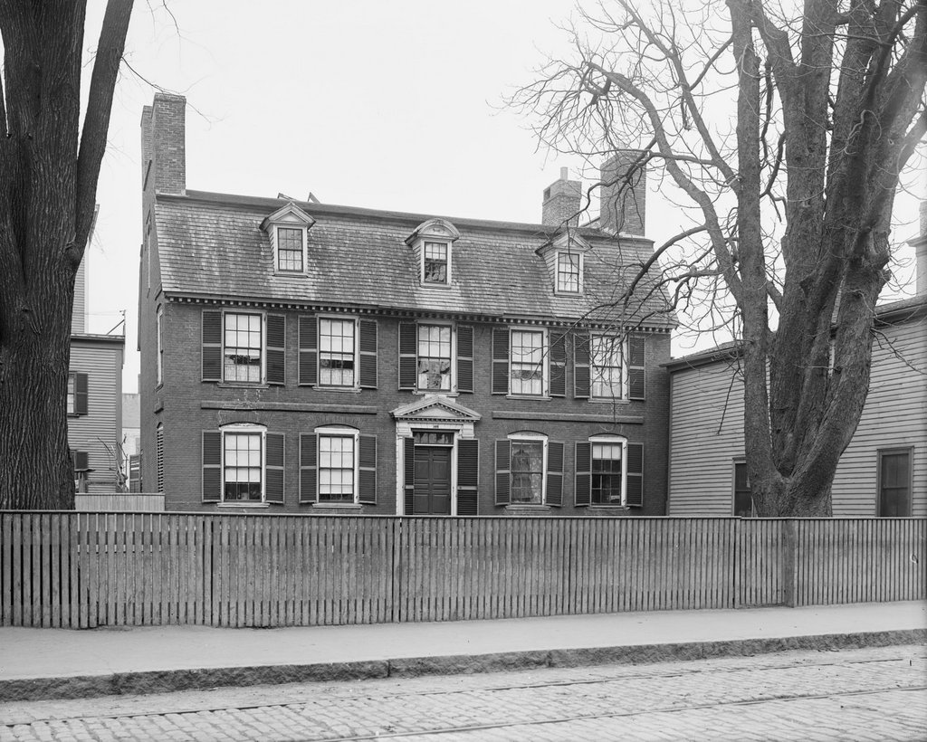
The Derby House on Derby Street in Salem, around 1910. Image courtesy of the Library of Congress, Detroit Publishing Company Collection.
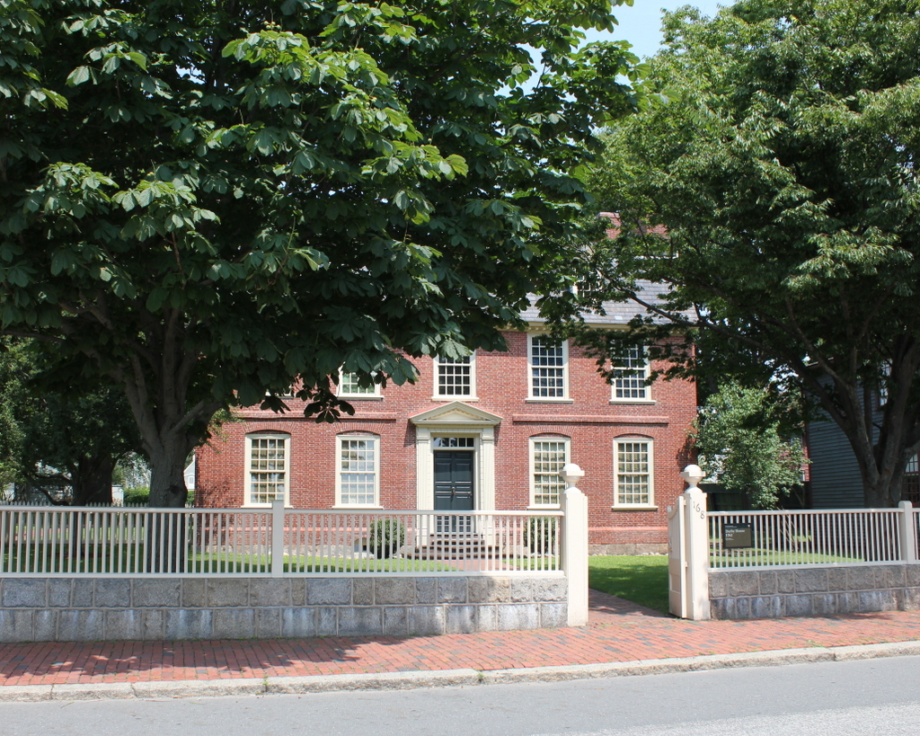
The house in 2019:

Salem was at the peak of its prosperity as a seaport during the late 18th and early 19th centuries, and perhaps no family better exemplified this golden age than the Derby family. The family patriarch was Richard Derby, a ship captain who lived most of his adult life in a house nearby at the corner of Derby and Herbert Streets. Derby eventually retired from sailing in 1757, and he spent the next few decades as a merchant here in Salem. He owned a fleet of ships, and in 1762 he began construction of Derby Wharf, which would eventually become the largest wharf in the port.

Richard and his wife Mary had three sons and three daughters. Two of their sons became ship captains, and the other son, Elias, joined his father in the merchant business. In 1761, at the age of 21, Elias married Elizabeth Crowninshield, and that same year his father began constructing this house for the newlyweds. The house was completed a year later, and it features a brick exterior with Georgian-style details, including a gambrel roof, which was typical for homes of this era. The architect and builder is unknown, although Joseph McIntire—father of the famous Salem architect Samuel McIntire—was apparently involved in the construction, because in 1762 Richard Derby paid him 40 shillings for unspecified work.

The house is situated on the north side of Derby Street, opposite Derby Wharf, where it overlooks the harbor. From here, Elias could keep a close eye on the activity at the wharf, which included the arrival of merchant ships and, during the American Revolution, privateers. He owned or held shares in about half of all the Salem privateers that preyed on British shipping during the war, and he made a significant profit from their success, while simultaneously benefitting the American war effort. Then, at the end of the war, these privateering ships were well-suited for conversion to merchant ships. This put Elias in a good position to expand foreign trade networks, and he became one of the first Americans to trade with China and other ports in southeast Asia.

By the late 18th century, Salem was the seventh-largest city or town in the country, along with being the richest on a per-capita basis. Elias Hasket Derby played a significant role in this prosperity, and he was regarded as one of the wealthiest merchants in New England at the time. Many years later, Nathaniel Hawthorne would famously give him the moniker “King Derby” in his prologue to The Scarlet Letter, in which Hawthorne recounted the glory days of Salem and contrasted them with the mid-19th century decline of the port city.

However, Elias and his wife Elizabeth did not live here in this house for his entire merchant career. They lived here through at least the early years of the Revolution, and raised their seven children here, but they appear to have moved elsewhere by around 1778. They were definitely gone by 1782, when they moved into a house closer to the center of Salem, at what is now the corner of Washington and Lynde Streets. Then, in 1799 they moved again, this time to a newly-built house designed by Charles Bulfinch. However, both Elias and Elizabeth died that same year, and that house was ultimately demolished in 1815 to build a new town hall.

In the meantime, the Derby family continued to own this house here on Derby Street for most of the late 18th century, before ultimately selling it to Henry Prince in 1796. Price, who apparently had begun renting the house from the Derbys as early as 1784, was a successful sea captain who sailed for some of Salem’s leading merchants, including Derby. He also played a role in the career of famed navigator and mathematician Nathaniel Bowditch; Prince was the captain on Bowditch’s first voyage, departing Salem in 1795 aboard the Derby-owned Henry.

Like many prosperous captains, Prince subsequently became a merchant, and by the early 19th century he had ownership interests in a number of vessels, including the appropriately-named 219-ton ship Golden Age. However, by this point the golden age of Salem was already nearing its end. Thomas Jefferson’s Embargo Act of 1807 severely damaged the American economy in general, but it was particularly devastating for Salem, which was dependent upon foreign trade. The War of 1812 caused further disruption to trade, and these financial hardships eventually forced Prince to sell both this house and his warehouse.

Various sources give somewhat different information as to when Prince lost his house, but in any case it was ultimately acquired by Henry Ropes, who married Henry Prince’s daughter Mary in 1821. Born in Salem in 1791, Ropes was the son of Captain George Ropes, who died at sea in 1807, and the brother of George Ropes Jr., a noted artist who specialized in maritime themes. Henry Ropes likewise became a ship captain, and made a number of voyages to India before retiring from the sea. He subsequently became involved in banking here in Salem, including serving for many years as the treasurer of the Salem Savings Bank.

Henry and Mary had nine children, three of whom died in infancy. Of their six children who survived to adulthood, most of them still died relatively young, with only two living past the age of 43. Henry died in 1861, but Mary continued to live her in her father’s old house until her own death in 1873. The 1870 census shows here with several generations of her family, including her only two living children, Joseph and Benjamin, who were both in their 30s and unmarried. She also shared the house with Priscilla, the widow of her oldest son George. Priscilla was 44 years old at the time, and she lived here with her daughters Priscilla and Mary, who appear to have been the only grandchildren of Henry and Mary Ropes who survived infancy.

Mary Ropes died in February 1873, and by late May the property, which was described in the Salem Register as consisting of a “two-story brick dwelling and other buildings and 22,000 square feet of land,” had been sold to Daniel Leahy for $6,700, or about $145,000 today. Leahy was an Irish immigrant who was about 26 years old at the time, and he moved in here with his wife Mary and their infant daughter Johanna. Just a few years earlier, during the 1870 census, the couple had been living in Peabody. According to the census, he worked as a laborer, had a personal estate of $150, and was unable to read or write.

The historical record does not seem to indicate how an illiterate immigrant laborer with $150 to his name in 1870 was able to, within three years, purchase a house that had once belonged to one of the wealthiest merchants in New England. However, this example serves to illustrate just how far Salem had fallen in prosperity since the days of “King Derby.” Nathaniel Hawthorne was no longer alive at this point, but if he had been he likely would have seen this as further proof of what he discussed in the prologue to The Scarlet Letter.

In any case, by the 1880 census Daniel and Mary were living here with a number of other family members. In addition to eight-year-old Johanna, they had a four-year-old son Thomas, and they also lived here with Daniel’s mother Johanna, his siblings Bartholomew, Michael, Mary, Catherine, and Margaret, and Bartholomew’s wife Catherine and infant son Patrick. Daniel and his two brothers all worked as stevedores, perhaps on the same wharves that Elias Hasket Derby had once built, and the three sisters worked in cotton mills. The family also had three young Irish women living here as boarders, all of whom also worked in cotton mills.

The Leahy family lived in this house until around the turn of the 20th century, but they continued to own the property for many years. The first photo was taken sometime around 1910, and that year’s census indicates that it was rented by two different families. In one unit was William and Annie Doyle, middle-aged Irish immigrants who lived here with their 11-year-old adopted daughter Agnes. In the other unit was John and Julia Szezechowicz, their four children, and John’s brother Bradislaw. They were all immigrants from Poland, arriving in the United States only three years earlier.

The house continued to be used as a residence, but it was eventually acquired by the Society for the Preservation of New England Antiquities in 1927. Now known as Historic New England, this organization restored the house to its original appearance, and then in 1937 transferred it to the National Park Service. A year later, the house became part of the Salem Maritime National Historic Site, which was established that year as the first national historic site in the country.

Today, the Derby House is still part of the Salem Maritime National Historic Site. It is partially hidden behind the trees in the present-day view, but it stands as one of the many well-preserved historic 18th and early 19th century homes in Salem. In the rear of the house, the property also includes a formal garden, which is a recreation of the gardens that were typical for Salem merchants of this period. Just to the left of the house, outside of view in this scene, is the Benjamin Hawkes House, and beyond it is the Salem Custom House, both of which have likewise been restored as part of the national historic site.

Old Meeting House, South Hadley, Mass

The Old Meeting House at the northern end of the town common in South Hadley, around 1930-1937. Image courtesy of Mount Holyoke College Archives and Special Collections.

The scene in 2023:

Although it is difficult to tell from its current appearance, this modest-looking colonial house is actually the original meetinghouse in South Hadley. It was built around 1732, when South Hadley was still a part of Hadley, and it is likely the oldest surviving church building in western Massachusetts. It is also one of the oldest in the entire state, dating back to a time when New England meetinghouses were typically built without steeples or bell towers.

European colonists settled in present-day South Hadley around the 1720s. These early residents would have been expected to attend church and town meetings in Hadley, but this proved challenging. The town center was eight miles away along rough roads, and South Hadley was geographically isolated from the rest of the town by Mount Holyoke. As a result, the settlers soon requested a church of their own, which was established around 1732. This meetinghouse was constructed around this time, and the building was originally situated about 100-150 feet south of its current location, on what is now the town common.

The first meeting appears to have been held here in March 1733, and the first pastor of the church was Grindall Rawson, who was ordained on October 3, 1733. He was a recent Harvard graduate who was about 25 years old, and five years later he married Dorothy Chauncey, the daughter of Reverend Isaac Chauncey of the Hadley church. During this time, work continued on the interior of the meetinghouse. This was done in several stages, beginning with the installation of nine pews in 1733, and it was not completed until 1744, when the gallery was finished.

It was not uncommon for early 18th century pastors to remain with the same church for their entire ministry career, but this ultimately was not the case for Reverend Rawson. Described in the 1863 History of Hadley book as “eccentric, free-spoken, and rash,” he soon became a source of controversy here in South Hadley. In 1737 a council of local clergymen met to discuss Rawson. Few details survive from this meeting, including where it was held, but one of the attendees was Jonathan Edwards, the famous pastor of the church in Northampton. He served as the scribe of the meeting, and in his memoirs he later wrote that the question at hand was “Whether Mr. R. was qualified for the work of the ministry as to his learning, his orthodoxy and his morals.” The council apparently found no issues with his qualifications, but this did little to appease his parishioners.

In February 1740, the congregation voted in favor of dismissing Rawson. However, he remained in that position for more than a year before, in March 1741, the church reaffirmed their decision and declared that “we have no further service for him in the office of a gospel minister, and that we expect he will refrain from any public acts in that office among us.” Rawson was apparently unfazed by this, though, and he continued to conduct services from the pulpit here throughout much of 1741. Finally, in October the church passed a resolution stating:

As Mr. Rawson has lately in an abrupt manner entered the meeting house and performed divine service, contrary to the mind of this precinct, the committee are directed and empowered to prevent Mr. Rawson from entering the meeting house on the Sabbath, by such means as they shall think best, except he shall promise not to officiate or perform service as a minister, and if Mr. Rawson shall offer to perform service as a minister, the committee shall put him forth out of the meeting house.

This still did not stop Rawson, who took to the pulpit a few weeks later. This time, though, a group of men seized him and forcibly carried him out of the building. The parish subsequently voted to appropriate 10 pounds as a legal defense fund, in the event that Rawson pressed charges against the men involved, but he did not, nor did he make any further attempts to preach here. He did, however, continue to live here in South Hadley for three more years, before accepting a position as pastor of a church in Hadlyme, Connecticut, where he served until his death in 1777.

In the meantime, South Hadley continued to grow in population, and this meetinghouse soon became too small for the parish. As early as 1751 the congregation voted to build a new church, but this caused a new controversy regarding its location. The residents here in the western part of the parish favored a site near the existing meetinghouse, while those in the eastern part—in present-day Granby—wanted the new church in a more central location on Cold Hill. After a decade of wrangling, the western faction finally prevailed, and the new church was built nearby in 1762. That same year, the eastern half of the district was established as a separate parish, and in 1768 it was incorporated as the town of Granby.

In the meantime, once the new church was completed the old building was moved northward to its current location, and it was converted into a house. This was a typical practice in New England during the 18th and 19th centuries, with thrifty Yankees generally preferring to move and repurpose old buildings instead of demolishing them. In the case of this meetinghouse, its relatively small size for a church—only 40 feet by 30 feet—made it well-suited for use as a house.

It is difficult to trace the ownership of the building in the early years after conversion to a house, but at some point in the first half of the 19th century it was owned by the Goodman family. It was then owned by Alfred Judd, who had been living there for “many years” by the time the History of Hadley was published in 1863. In a footnote, the author remarked that it was a “comely dwelling,” and that its old frame “may yet last a century.” More than 150 years later, this prediction that has proven to be a significant underestimate of the building’s longevity.

The 1860 census shows Alfred Judd living here with his daughter Irene, her husband Joseph Preston, and their two young children, Alfred and Joseph Jr. Alfred was 62 years old at the time, and he had just recently been widowed after his wife of 38 years, Mary, died in February 1860. He subsequently remarried to Sophia Preston in 1861, and he appears to have lived here until his death in 1878.

At some point afterward, Judd’s grandson Joseph Preston Jr. purchased the property to the right of the family home and built the Hotel Woodbridge, which later became Judson Hall, a dormitory for nearby Mount Holyoke College. In the meantime, the old house remained in the Preston family for many years. Joseph Jr. died in 1922, but his widow Elmina continued to own it until at least the 1930s, although it seems unclear as to whether Joseph or Elmina actually lived here during the early 20th century, or simply rented it to other tenants.

In any case, the first photo was taken at some point during Elmina’s ownership in the 1930s. By then, the building was the home of the Old Meeting House Tea Room, as indicated by the sign above the front door. It is difficult to determine exactly how much its exterior appearance had changed by this point, but it was clearly different from how it would have looked when it was moved here in the early 1760s. In particular, the wide pediment just below the roof and the pilasters in the corners are most certainly not original; these would have probably been added around the early 19th century, giving the old colonial meetinghouse a vaguely Greek Revival appearance.

In more than 80 years since the first photo was taken, this building has undergone some significant changes, including additions to the left, right, and behind the original structure. The front of the building has also been altered, particularly on the ground floor, but overall it is still recognizable from the first photo. Throughout this time, it has continued to be used as a commercial property, and it is currently the Yarde Tavern restaurant. The second floor of the building was damaged by a fire in April 2019, but the building survived and the restaurant itself was only closed for a few weeks.

Today, the building bears almost no resemblance to the Puritan meetinghouse that Grindall Rawson was dragged out of nearly 280 years ago. However, it despite these changes it still has significant historic value as one of the oldest buildings in South Hadley, in addition to being one of the few surviving early 18th century church buildings in this part of the state.

Judson Hall, South Hadley, Mass

The view looking north on College Street toward the intersection of Hadley Street in the center of South Hadley, around 1912. Image from In Old South Hadley (1912).

The scene in 2019:

The first photo was taken sometime in or before 1912, and it shows Judson Hall, a dormitory for students at nearby Mount Holyoke College. This building was originally constructed in the late 19th century as the Hotel Woodbridge, which was owned by Joseph S. Preston Jr. References to the hotel first appear in local newspapers around 1896, and it appears to have been in business for about a decade or so. Most of these newspaper advertisements mention the hotel’s “spacious piazzas,” which ran along the south and east sides of all three stories, and an 1898 ad lists the rates as ranging from $8 to $14 per week.

The hotel was temporarily used to house Mount Holyoke students in 1896, after the main college building was destroyed in a fire on September 27. Then, in 1908 the college purchased the hotel and renamed it Judson Hall in honor of Judson Smith, who had served as president of the board of trustees from 1894 until his death in 1906. It was subsequently used as a dormitory for the next 24 years, before being closed in 1932.

Judson Hall was demolished two years later, and the property was sold to the federal government to construct a post office here. The loss of the old hotel-turned-dormitory was evidently seen as an improvement by many people at the time, including the Springfield Republican, which wrote in 1934 that “Not only has it proved inadequate as a residence and inappropriate for business activities, but also its style of architecture has disturbed the harmony and beauty of South Hadley for many years.”

Today, the post office is still standing here in the center of this scene, and the only surviving building from the first photo is the one on the far left. Although it looks like an ordinary colonial-era house, it was actually built around 1732 as South Hadley’s first meeting house. It was only used as a church for a few decades though, before it was replaced by a new larger church in 1764. The old building was then moved here to this site and converted into a house, and more recently it has been occupied by a number of different restaurants. It is currently the Yarde Tavern, and despite the many alterations it is perhaps the oldest surviving church building in western Massachusetts.

Mount Holyoke Summit, Hadley, Mass

A group of visitors sitting on the rock ledges near the summit of Mount Holyoke in Hadley, around the 1860s or 1870s. Image courtesy of the New York Public Library.

The scene in 2019:

As discussed in the previous post, Mount Holyoke is a traprock mountain on the Metacomet Ridge, which runs roughly south to north from Long Island Sound to near the Massachusetts-Vermont state line. Although relatively low in elevation compared to the mountains of the nearby Berkshires, the ridge runs through the middle of the Connecticut River Valley providing dramatic views from atop the steep rocky cliffs. At 935 feet in elevation, Mount Holyoke is a few hundred feet lower than the highest peaks on the ridge, but it offers perhaps the most impressive views of any mountaintop in southern New England. Here, the Connecticut River flows through a narrow gap between Mount Holyoke to the east and Mount Nonotuck to the west, and the river is visible for miles in both directions.

The river takes a meandering course through the flat river valley to the north of Mount Holyoke. The most famous of these meanders is the Oxbow, a three-mile-long U-shaped bend in the river at the base of the mountain. This prominent natural feature was the focal point of Thomas Cole’s 1836 painting The Oxbow, which portrays the scene from near this spot at the summit. His work went on to become one of the most important 19th century American landscape paintings, but the actual view here from Mount Holyoke changed dramatically only a few years later. In 1840, a flood cut through the narrow neck of land in the middle of the bend, and the main current of the river shifted to the new shorter route, turning the Oxbow into a side channel.

The first photo was taken only a few decades later, and it shows the wide river passing through the lower right side of the scene, with the circular Oxbow beyond it in the distance. By this point, Mount Holyoke was a popular destination for visitors, including the well-dressed group of women sitting on the rocks in the foreground. Directly behind them, barely visible on the far left side, is the corner of the Summit House, also known as the Prospect House. This hotel was built in 1851, replacing an earlier building on the site, and it provided accommodations and refreshments for guests who either hiked up or took the inclined railway to the summit. The man in the center of the photo could very well be hotel owner John French or one of his employees, as the hotel provided telescopes for mountaintop visitors.

The hotel steadily expanded during the second half of the 19th century, and at some point a porch was added to the northern side of the building, as shown in the present-day photo. However, by the early 20th century mountaintop hotels had passed their heyday. Thanks to modernization efforts of Holyoke silk manufacturer Joseph Skinner, the Summit House remained viable for many years, but it ultimately closed after sustaining heavy damage in the 1938 hurricane. A large wing of the building, which had been added in 1894, was demolished after the hurricane, and in 1939 the property was donated to the state, becoming the Joseph Allen Skinner State Park.

Today, this scene at the summit of Mount Holyoke is still easily recognizable from the first photo, despite a conspicuous lack of women in hoop dresses. The Summit House is still standing, after having been restored in the 1980s, and it is now open seasonally as a museum. Further in the distance, the Oxbow is still there, although somewhat less prominent than in the first photo.

Part of the reason for this might be because of the increased tree growth along its banks, but also because the Oxbow has been heavily altered in the 20th century. It is now closed off from the upstream side, with only a narrow channel on the downstream side to link it to the Connecticut River. Along with this, Interstate 91 now passes directly over it, and a large chunk of the land inside the curve has been carved out to create a marina. As a result, it bears little resemblance to the undisturbed natural feature that Cole painted nearly 200 years ago, but it remains an important landmark that has long been associated with this view from Mount Holyoke.

Connecticut River and Mount Tom from Mount Holyoke, Hadley, Mass

The view looking south from the Mount Holyoke Summit House in Hadley, around 1900. Image courtesy of the Library of Congress, Detroit Publishing Company Collection.

The scene in 2019

One of the most important geological features in the Connecticut River Valley is the Metacomet Ridge, a long narrow traprock formation that runs roughly parallel to the river. It passes through central Connecticut and western Massachusetts, running from Long Island Sound to just south of the Vermont border. Its peaks are relatively low in elevation compared to the mountains of the Berkshires further west, with few reaching above a thousand feet, but the ridge stands out in the landscape because it rises so high above the surrounding low-lying river valley.

Because of this prominence, the Metacomet Ridge offers expansive views from atop its steep traprock ledges. However, perhaps none of these views are as celebrated as those from Mount Holyoke, which sits on the border of Hadley and South Hadley, Massachusetts. The 935-foot mountain is in the middle of a ten mile section that features some of the highest elevations of the entire ridgeline. This section is bookended by the two highest peaks of the Metacomet Ridge, with the 1,200-foot Mount Tom at the southern end and the 1,106-foot Mount Norwottuck to the east.

Although Mount Holyoke is comparatively lower in elevation, it has a unique position. Here, the ridge takes a sharp 90-degree turn across the Connecticut River, forming two perpendicular ranges bisected by the river. Mount Holyoke is located directly east of the river, so the top of the mountain provides dramatic views of the river as it winds its way through the surrounding farmland. Most famously, these scenes inspired 19th century artist Thomas Cole to paint The Oxbow, one of the most iconic landscape paintings in the history of American art.

The view captured in The Oxbow is not the same direction as the two photos shown here in this post. Cole’s painting faces almost due west, while these two photos were taken facing south, looking downstream on the river with the city of Holyoke in the distance on the left and Mount Holyoke on the right. Unlike the views to the west or north from the summit, this southern view is not nearly as celebrated in paintings or photographs. Part of this might be because the viewer is typically facing into the sun in this direction, creating a backlit scene. Another reason might be because the mountain has a much more gradual southern slope, so the landscape seems more distant when compared to the views from atop the steep northern and western cliffs.

Either way, the scene in the first photo shows some interesting contrasts. The jagged spine of the Metacomet Ridge runs across the horizon of the photo, parallel to the gently curving Connecticut River in the center of the scene. Further to the left, the prosperous industrial city of Holyoke in the distance contrasts with the open fields and scattered farmhouses of the foreground. The view is somewhat different in the present-day scene, as the trees now obscure most of the foreground, but both the river and the ridgeline remain dominant features in the landscape.

Both of these photos were taken from the porch of the Summit House, which was built in 1851 and expanded several times in the second half of the 19th century. At the time, mountaintop resorts were particularly popular, and the Summit House here on Mount Holyoke was just one of three in the vicinity; the others included the Eyrie House atop Mount Nonotuck, and the Summit House on Mount Tom, which is visible in the distance on the right side of the first photo.

It is difficult to tell, but the Mount Tom building in the photo appears to have been the first of three successive ones at the summit. This one burned in 1900, probably soon after the photo was taken, and it was subsequently rebuilt twice in the early 20th century. The Eyrie House likewise burned in 1901 and was never rebuilt, yet the Mount Holyoke hotel has managed to avoid such a fate, and the building is still standing today as a museum.

More than a century after the first photo was taken, and nearly two centuries after Thomas Cole made the mountain famous, much has changed in the view from Mount Holyoke. The land is actually far more forested now than it was at the turn of the 20th century, so in some ways there are actually fewer obvious signs of human development. However, the abundance of trees also makes very clear the swath that Interstate 91 cuts across the modern-day landscape, about halfway between the river and the mountains.

Despite these changes, though, the view from Mount Holyoke remains perhaps the most impressive landscape view in southern New England. Although overnight guests no longer stay at the Summit House, the mountain remains a popular destination, with visitors driving up the auto road or climbing the relatively short hike from the base. In 1939, the summit and the surrounding land became the Joseph Allen Skinner State Park, after its namesake donated the land to the state. Much of the remaining land along the Holyoke and Mount Tom ranges has similarly been preserved, and the area affords some of the best hiking and other outdoor recreation opportunities in the Connecticut River Valley.