Washington Street, Boston

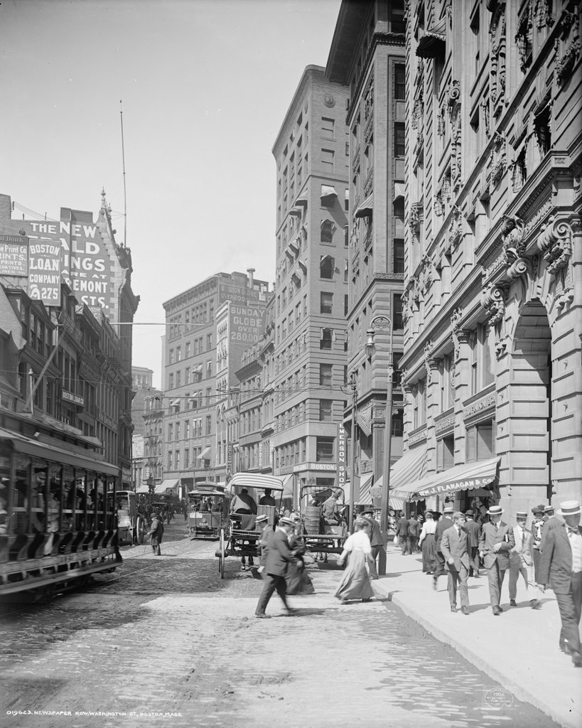
Looking north on Washington Street from School Street in Boston, around 1906. Image courtesy of the Library of Congress, Detroit Publishing Company Collection.

779_1906c loc

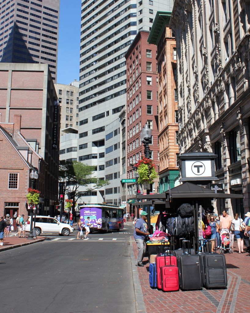
Washington Street in 2015:

779_2015
In the days before radio, television, and internet, the only major news source for most people was newspapers.  At the turn of the 20th century, large cities had many newspapers, which were often published twice daily.  However, for timelier updates, newspapers often posted breaking news, election results, and sports scores on bulletin boards outside of their offices.  In some cities, such as New York and here in Boston, many newspapers had offices in the same area, known as Newspaper Row.

Boston’s Newspaper Row was located along Washington Street, between Milk and State Streets, and at one point included up to 17 newspapers, including several in this scene.  On the far left of the first photo, partially blocked by the trolley car, is the Boston Post, and further down the street, the tall building to the left had been the home of the Boston Herald.  As the advertisement on the building indicates, the Herald had recently moved to a new location on Tremont Street.  Both the Post and the Herald buildings have since been demolished, and a parking garage now stands there.  The Post, which was established in 1831, was a major daily newspaper in New England until it closed in 1956.  The Herald, however, is still around today, 170 years after it was first published in 1846.

The large building in the distance in the left-center of the first photo was the home of the Boston Globe, the narrow building next to it was the Boston Advertiser, and the tall building in the center of the photo was the Boston Journal.  Of these three, the Globe was by far the newest of these newspapers, having been established in 1872.  The Advertiser, on the other hand, had been published since 1813 as the first daily newspaper in the city, and the Journal since 1833. However, the Globe ended up outliving both of them, as the Journal merged with the Herald in 1917, and the Advertiser was purchased by William Randolph Hearst the same year and was discontinued in 1929.  Both the Globe and the Advertiser buildings here have since been demolished, but the Journal building still stands as the only survivor of the five turn-of-the-century newspaper buildings in this scene.  The building opened in 1901, and was the home of the Journal until its merger with the Herald.  Since then, it has been used for other professional offices.

There are no longer any newspaper offices along this section of Washington Street; the Globe left in 1958, and it has been many years since Newspaper Row was the center of news information in the city.  It is also much less crowded; the first photo shows the narrow street filled with pedestrians, carriages, and trolleys, but within a few years the Washington Street Tunnel would be completed.  This subway tunnel eliminated some of the congestion by taking the trolleys off of the streets, and it formed the precursor to today’s Orange Line, which still runs under this section of Washington Street.

Despite the changes over the years, there have been several constants.  The Old Corner Bookstore, which is just out of view in the first photo but visible on the far left in the second one, is the oldest of them all.  It was built in 1712, and it is still standing as one of the oldest buildings in downtown Boston, and just beyond it is the Andrew Cunningham House, which was built a few years later around 1725.  Aside from these two colonial-era buildings, though, there are several other historic buildings in the scene.  On the far right is the Old South Building, a large office building that was completed shortly before the first photo was taken.  It wraps around the Old South Church between Washington and Milk Streets, and its Milk Street facade can be seen in this post.  The other prominent historic building here is the Winthrop Building, located just beyond the Old South Building at the corner of Washington and Water Streets.  A view of the long side of this building can be seen in the “now” photo of this post, which shows it from the Water Street side.  It was built in 1893 on a long, narrow, irregularly-shaped lot, and it was Boston’s first steel frame skyscraper.  It is still standing today, and is now on the National Register of Historic Places.

Chickering Hall, Boston

Chickering Hall on Huntington Avenue near Massachusetts Avenue in Boston, around 1901-1906. Image courtesy of the Library of Congress, Detroit Publishing Company Collection.

771_1900-1906 loc

The site in 2015:

771_2015
This section of Huntington Avenue is also known as “Avenue of the Arts,” and it is home to a number of theaters, as well as Northeastern University, the Massachusetts College of Art and Design, and the Museum of Fine Arts.  One of the early concert halls here was Chickering Hall, which was built in 1901 by Chickering & Sons, a Boston piano manufacturer.  The name didn’t last for long, though; it was sold in 1912 and became the St. James Theatre.  The new owners renovated the building and doubled the seating capacity from 800 to 1,600, and it was used for both vaudeville performances and early films.

In 1929, it was renamed the Uptown Theatre, and a large vertical neon sign and marquee were added to the front entrance.  It was primarily a second run movie theater for local college students, and it lasted until 1968, when it was demolished to build the Christian Science Center, which features the Mother Church and the religion’s administrative offices.  There is one landmark still standing in the first photo, though.  Horticultural Hall, located just to the left of Chickering Hall, was also built in 1901, and it is still standing today, at the corner of Huntington Avenue and Massachusetts Avenue.

Copley Square Hotel, Boston

The Copley Square Hotel at the corner of Huntington Avenue and Exeter Street, around 1909. Image courtesy of the Library of Congress, Detroit Publishing Company Collection.

770_1909c loc
The hotel in 2015:

770_2015
Not to be confused with the nearby Copley Plaza Hotel, this historic hotel was built in 1891 and has remained here for the past 125 years.  It was originally located at the edge of a large rail yard, with the tracks coming all the way up to the west side of Exeter Street, just out of the frame to the left.  Despite the name, the hotel is actually a block away from Copley Square, but it was still a convenient location for guests.  By the time the hotel opened in 1891, Copley Square had become a major cultural center in Boston, with the Trinity Church, New Old South Church, Museum of Fine Arts, and MIT all located right around the square, and the Boston Public Library’s McKim Building under construction at the time.

In the century since the first photo was taken, this section of the Back Bay south of Boylston Street has undergone some dramatic changes.  The rail yard was replaced with the Prudential Center in the 1960s, and some of Boston’s tallest buildings are within a couple blocks of here, including the John Hancock Tower, the Prudential Tower, and 111 Huntington Avenue.  Other historic buildings, including Mechanics Hall just down Huntington Avenue from here, have been demolished, but the Copley Square Hotel is still standing as the only surviving 19th century building on Huntington Avenue between Copley Square and Massachusetts Avenue.  The building’s interior was extensively renovated in 2008, but from the outside it doesn’t look much different today than it did in 1909.

Post Office, Monson, Mass

The post office at the corner of Main and State Streets in Monson, around 1893. Image courtesy of the Monson Free Library.

751_1893c mfl

The scene in 2015:

751_2015
The building in the first photo was built in 1855 for the recently-established Monson National Bank.  In 1872, Monson Savings Bank was also created, and the two companies shared the same counter, tellers, and vault within this small building until 1893, when a larger one was completed just a short walk down Main Street from here.  That same year, the nearby Central Block, which housed the post office, was destroyed in a fire, so the post office was moved to the recently-vacated bank building.  It later moved back to the Central Block location when a new building was completed on the site.

I don’t know exactly when it was demolished, but it would have been sometime before 1925, when the original Monson High School was built here.  The school building was converted into the town offices in the early 1990s, but it sustained heavy damage in the une 1, 2011 tornado, and it was demolished in 2013.  A new town office building, seen to the right in the 015 photo, was completed earlier in the year.

Monson Savings Bank, Monson, Mass

Monson Savings Bank on Main Street, around 1893-1910. Image courtesy of the Monson Free Library.

748_1892-1910c mfl

The building in 2015:

748_2015
Monson’s first bank was Monson National Bank, which opened in 1854. It was a commercial bank, so it primarily served the business community in town, rather than on individual checking and savings accounts. So, in 1872, Monson Savings Bank was established, which enabled middle class workers in town to open savings accounts.  The two banks were officially separate, but they shared the same building, and the same vault, counter, tellers.

This arrangement continued until 1893, when this building was completed.  Although still located in the same building, they were separated, with Monson National on the left and Monson Savings on the right.  Monson National merged with the Springfield Safe Deposit and Trust Company, which in turn merged with Shawmut Bank.  Shawmut continued to operate a branch in this building until the 1960s, when Monson Savings Bank acquired the entire building.

Over 120 years after this building was completed, Monson Savings Bank is still here, although the building itself has undergone dramatic changes.  The two upper floors were removed at some point, and in the 1960s the front facade was completely rebuilt.  Another renovation in 1985 added office space in the back and a drive-up teller window to the left, so today the only surviving parts of the original exterior are the walls on the left and right.

Nora’s Variety Store, Springfield, Mass

A mixed-use commercial and residential building on Boston Road in Springfield’s Pine Point neighborhood, on October 12, 1938. Image courtesy of the Springfield Preservation Trust.

747_1938-1939 spt

The building in 2015:

747_2015
This building is probably best known as the longtime home of Nora’s Variety Store, but on a more personal note it is also where my grandmother was born. It was built sometime between 1899 and 1910, when the Pine Point neighborhood was first being developed, and it was apparently a two-family home. My great grandparents, Frank and Julia Lyman, moved here around 1915, and they lived here for about two years.

Frank was originally from Wilbraham, and he attended Wesleyan Academy before becoming a machinist. He worked for Pratt and Whitney in Hartford, and later for the Otis Elevator Company in Springfield, and he also spent some time in New York City, where he met his wife Julia Brown. She was the daughter of Irish immigrants, and prior to her marriage she worked in the biographical department for the New York World newspaper. By the time they moved to Springfield they had two young children, Elizabeth and Edith, and their third child, my grandmother Evelyn, was born here in 1917. Soon after, the family moved nearby to a house at 37 Coleman Street, where they lived for many years.

During the 1920s the house had a number of different tenants, who rarely seem to have lived here for longer than a year or two. Then, as this section of Boston Road became increasingly commercial, the house was altered with the addition of two storefronts, as shown in the first photo (an earlier photo on a different blog post, taken from a different angle, shows a the front of the house prior to this addition). This photo was taken in 1938, and by this point the storefronts were occupied by the Boston Road Variety Store—which later became Nora’s Variety Store—on the left, and a shoe store on the right.

Today, nearly 80 years after the first photo was taken, much has changed on Boston Road. Many of the late 19th and early 20th century homes have been demolished over the years, including the one on the far right side of this scene, where a car dealership is now located. Nora’s Variety Store was located here in this building for many years, but it ultimately closed in the early 2000s, and the storefront is now vacant. The building itself has also changed, including the addition of artificial siding, which probably occurred sometime during the mid-20th century. However, the building is still easily recognizable from the first photo, and it stands as a reminder of the days when Boston Road was still predominantly a residential street.