Old Union Station, Springfield, Mass

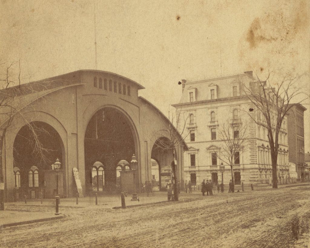
The old railroad station on Main Street in Springfield, around 1870-1885. Image courtesy of the Boston Public Library.
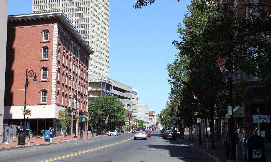
The scene in 2024:

Railroads first came to Springfield in 1839, with the opening of the Western Railroad from Worcester to Springfield, and the line terminated here at a wooden, Egyptian Revival-style railroad station on the west side of Main Street. The railroad was later extended west through the Berkshires, and Springfield became an important midway point on the route between Boston and Albany. The original station stood here for 12 years, but in 1851 it was destroyed in a fire after sparks from a passing locomotive ignited the building.

A new station was soon built on the same site, as seen in the first photo. Like the first station, trains passed directly through the building, although this one was less flammable, having been built with brick and iron. Architecturally, this new station was unremarkable, resembling a large shed rather than a grand union station, but it was designed by railroad engineer George William Whistler, the older brother of the famous painter James Abbott McNeill Whistler. Their father, George Washington Whistler, had briefly lived in Springfield in the early 1840s, and had been the chief engineer of the Western Railroad during the construction of route through the Berkshires.

The new station was joined in the late 1860s by a new office building for the Western Railroad, which was located just north of the station on the right side of the first photo. A striking architectural contrast compared to the plain railroad station, this granite Second Empire-style building was one of the earliest works of Henry H. Richardson, who would go on to become one of the most important architects in American history. Although very different from his later Romanesque Revival buildings, this design reflected his education in France’s École des Beaux Arts, and it helped to establish him as a notable architect.

In 1867, around the same time that Richardson received his commission for the building, the Western Railroad merged with the Boston and Worcester Railroad, forming the Boston and Albany Railroad. Both the station and the office building became part of the new railroad, but by this point it was obvious that the station, less than 20 years old, was already obsolete. As a union station, it served not just the Boston and Albany, but also the Connecticut River Railroad, and the Hartford and New Haven Railroad. Because of this, essentially all rail traffic from the four cardinal directions had to pass through this station, and Springfield’s rapidly growing population was straining the station’s capacity.

Along with overcrowding, the station’s location also caused problems, since the railroad tracks crossed Main Street just to the east of the station, as seen in the first photo. The busy railroad traffic meant that the Main Street crossing gates were closed as often as they were open, with an 1872 observer noting that the gates closed 66 times during one four-hour span from 11 a.m. to 3 p.m. This  caused a significant disruption to the busy pedestrian, carriage, and trolley traffic in downtown Springfield, but the problem persisted for several decades, with neither the city nor the Boston and Albany Railroad wanting to pay the expense of lowering the grade of Main Street or raising the grade of the railroad.

Because of this impasse, the old station remained in use well into the 1880s, since the railroad was unwilling to build a new station until the tracks were raised above street level. It was not until February 1888 that the two sides reached a compromise, with the railroad agreeing to spend $200,000 to raise the tracks and build a stone arch over Main Street, while the city would spend $84,000 to lower Main Street by four feet, and would settle any damage claims by adjacent property owners. Most significantly, though, this project meant the construction of a new railroad station, which would be built across the street from here on the east side of Main Street.

The old railroad station was demolished in the spring of 1889, but the platforms and two waiting rooms were left standing until the new station opened in July. Like the older railroad office building, the new station was based on the designs of Henry H. Richardson, although he died before construction began, and his successors made some significant alterations to his original plans. The entire project was finished once the railroad arch was completed in 1890, finally eliminating the long-problematic grade crossing on Main Street.

Despite all of these changes, the Boston and Albany office building remained standing well into the 20th century, and continued to be used even after the railroad was acquired by the New York Central in 1900. The building was finally demolished in the late 1920s, around the same time as the 1889 railroad station. Despite being less than 40 years old, this station had become obsolete as quickly as its predecessor, and in 1926 it was replaced by the current Union Station on the same site. However, the stone arch is still here, and still serves as an important downtown landmark on Main Street.

Main and Vernon Streets, Springfield, Mass

The corner of Main Street and Vernon Street (now Boland Way) in Springfield, around 1938-1939. Image courtesy of the Springfield Preservation Trust.

The scene in 2017:

Located in the midst of Springfield’s central business district, this scene has long the site of commercial buildings. The first photo shows a small Art Deco-style building that was probably built only a few years earlier. At the time, downtown Springfield was the retail center of western Massachusetts, and this scene shows a few of the many shops that lined Main Street in the late 1930s. The most prominent of this buildings’s three tenants was Bell Shops, a women’s clothing store that occupied the corner storefront. Just to the right was Morse and Haynes, a shoe store that had been in business here in Springfield since 1895 and, according to its advertisement in the 1939 city directory, sold shoes, hosiery, and rubber footwear, and also repaired shoes. The first photo also shows another shoe store, Thom McAn, which was located right next to Morse and Haynes on the right side of the building.

Both Bell Shops and Thom McAn were still located here into the mid-1960s, as indicated in city directories of the era. However, the building was demolished by the end of the decade to make way for Baystate West, a massive redevelopment project that encompassed the entire block between Main Street, Vernon Street, Bridge Street, and East Columbus Avenue. Completed in 1970, it included a two-story mall, a parking garage, a hotel, and a 29-story skyscraper that was, by far, the tallest building in Springfield at the time. Today, this scene has not significantly changed since 1970, although Baystate West has since been renamed Tower Square. The present-say view shows the main entrance to the mall, with the parking garage located directly above it. In the distance on the left is the hotel, formerly a Marriott, and on the right is a portion of the tower, which is now the second-tallest in the city after the completion of the adjacent Monarch Place in 1987.

Forbes & Wallace, Springfield, Mass

The Forbes & Wallace department store on Main Street in Springfield, around 1938-1939. Image courtesy of the Springfield Preservation Trust.

The scene in 2017:

For just over a century, Forbes & Wallace was one of Springfield’s leading businesses, with its department store located here at the corner of Main and Vernon Streets. The company was established in 1874, when Scottish immigrant Andrew Wallace formed a partnership with Alexander B. Forbes, a dry goods merchant here in Springfield. They rented space in an earlier building that stood at this same location, and within a decade the two men had built the company into, as described in the 1884 King’s Handbook of Springfield, “the largest and most prominent wholesale and retail dry-goods house in Massachusetts, excepting only some of those in Boston.”

By this point, Forbes & Wallace had purchased the entire building, modifying it to meet the needs of the company’s growing business, but around 1905 the old building was demolished and replaced with a new Classical Revival-style building that is seen in the first photo. Only a portion of this massive building is visible in this scene, though. The eight-story, L-shaped structure extended for a significant length along Vernon Street (today Boland Way), and wrapped around the Haynes Hotel so that part of the building fronted on Pynchon Street. Over time, the company’s complex would come to fill almost the entire city block, including its own parking garage on the western side, and the department store remained a Springfield landmark for many years.

Alexander Forbes has retired from the business in 1896, but Andrew Wallace remained with the company until his death in 1923, nearly 50 years after he had established it. His son, Andrew B. Wallace, Jr., and later his grandson, Andrew B. Wallace III, both succeeded his as president of the company, which remained in the Wallace family for many years. The first photo was taken in the late 1930s, during the time when downtown department stores still dominated retail shopping. Aside from Forbes & Wallace, this section of Main Street also feature its largest competitor, Steigers, along with a variety of smaller stores. The scene in the first photo shows Main Street lined with parked cars, and the blurred figures on the sidewalk and in the street give the impression of a busy shopping district.

In the decades that followed, though, suburban malls began to eclipse downtown stores, and Forbes & Wallace followed this trend, opening satellite stores at the Eastfield Mall on Boston Road and the Fairfield Mall in Chicopee. Around the same time, downtown Springfield underwent several large-scale projects aimed at urban renewal, including the construction of the 371-foot, 29-story Baystate West building, which was located directly opposite Forbes & Wallace on the north side of Vernon Street. Now known as Tower Square, this project was completed in 1970, and included a shopping mall that was connected to Forbes & Wallace via a skywalk.

The Baystate West mall evidently did little to revive Forbes & Wallace, though, and the store ultimately went out of business in 1976. The building sat vacant for the next few years, and it was finally demolished in the early 1980s to make way for Monarch Place, a skyscraper that is just out of view on the left side of this scene. Completed in 1987, it is currently the tallest building in the city, and the original site of Forbes & Wallace at the corner is now a small plaza. There is a small replica facade on the left side, partially visible from this angle, but otherwise there is no trace of the old department store. Today, the only building left from the first photo is the Haynes Hotel, which stands as the only 19th century structure amid a variety of 20th century urban renewal projects.

Thames and Mill Streets, Newport, RI

The southeast corner of Pelham and Mill Streets in Newport, around 1885. Image courtesy of the Providence Public Library.


The scene in 2017:


The first photo shows a mix of old, wood-frame commercial buildings on the east side of Thames Street, just south of Mill Street. The building on the left may have been the oldest in the scene, and probably dated back to the mid or late 18th century, with a large gambrel roof that commonly seen in Newport buildings of this era. It may have originally been built as a house, but by the time the first photo was taken it housed a variety of businesses, including the Newport Daily Observer newspaper, which had its offices in the storefront on the left side, and Edward Otto’s tailor shop, which was located on the right side. At the corner of the building, there is also a large sign for Child & Co. photographers, which had their studios here in the building.

Just to the right is a tall, narrow commercial building with a large clock hanging from the second floor. According to the National Register of Historic Places inventory, it was built sometime between 1741 and 1758, but was renovated in the 1850s. It does not seem clear how much is left from the original 18th century structure, but it was likely a single-family home that, like many other colonial-era Thames Street buildings, was converted into commercial space in the mid-19th century. By the 1860s, the ground floor of the building was the site of H.W. Pray’s watchmaking and jewelry business, and in 1873 the business was acquired by Edwin C. Blaine. He was still running the business here when the first photo was taken, and the watch sign became a longtime feature here on Thames Street.

To the right of Blaine’s store was another old commercial building that probably dated to the 18th or early 19th century. The building is too far from the camera to read any signs, but city directories of the mid-1880s show that it was the home of Richard Swan’s piano and organ business. However, the old building was demolished soon after the first photo was taken, and in 1894 it was replaced by the current three-story brick building. Known as Music Hall, it was owned by liquor dealer Dennis W. Sheehan, and early tenants included James A. Eddy’s grocery store and William H. Hilton’s hairdresser shop.

Of the three buildings in the first photo, only the Blaine building in the middle is still standing. Blaine operated his shop here until his death in 1904, and his son Joseph W. Blaine subsequently took over the jewelry business. He would run it for nearly 50 years, before finally selling it in 1952, a year before his own death. The store would remain here for many more years, still bearing the Blaine name, before finally closing sometime in the 1970s, after more than a century in business. However, the building is still there, with an exterior that is essentially unaltered. Even the storefront is mostly unchanged, and a large clock still hangs from the second floor, as a reminder of the watch and jewelry business that was once here.

Thames and Pelham Streets, Newport, RI (3)

Looking south on Thames Street toward the corner of Pelham Street in Newport, around 1885. Image courtesy of the Providence Public Library.

The scene in 2017:

The scene in the first photo shows a mix of commercial buildings on the east side of Thames Street, from the corner of Pelham Street to Green Street a block away in the distance. Starting on the left side is the United States Hotel, which is explained in further detail in a previous post. Built in 1836 on the site of the earlier Townsend’s Coffee House, it was one of Newport’s leading hotels of the mid-19th century, and in the first photo the building also housed William P. Weeden’s “Ladies & Gent’s Restaurant” on the left and William T. Rutherford’s cigar shop on the right.

In the middle of both photos is the Newton Building, which is also explained in more detail in a previous post. This Romanesque-style commercial block was built a few years before the first photo was taken, and housed several businesses including the Adams Express Company and Frank L. Powell’s pharmacy. Just beyond the Newton Building, in sharp architectural contrast, was an 18th century house that had been converted into commercial use around the mid-19th century. It had been the childhood home of Elizabeth Champlin Mason, and it was where, in 1811, she married Oliver Hazard Perry, the Newport native who would later achieve fame as a naval hero in the War of 1812.

To the right of the former Mason house is the brick, three-story Savings Bank of Newport Building. The bank had been established in 1819, and occupied several different locations before this building was completed in the mid-1870s. When the first photo was taken, the building also housed the Aquidneck National Bank. However, in the early 1890s this bank moved across Green Street to the newly-built Kinsley Building, a two-story, Romanesque-style stone building that can be seen in the distance of the 2017 photo.

In more than 130 years since the first photo was taken, Thames Street has undergone some dramatic changes, most notably in the late 1960s when all of the buildings on the right side of the street were demolished to build America’s Cup Avenue parallel to Thames Street. Some of the older buildings on the left side have also been demolished or altered beyond recognition, including the United States Hotel. It closed in 1918, and sat vacant for the next 15 years until the top three floors were removed in 1933. The current building on the site appears to be the surviving first floor of the United States Hotel, although there are no recognizable details left from the first photo.

Further in the distance, the Mason house was demolished in the late 1950s to build a parking lot, but the two late 19th century buildings on either side of it – the Newton Building and the Savings Bank of Newport Building – are still standing, with few significant exterior alterations. Although built a few years after the first photo was taken, the Kinsley Building is also still there, and all three of these buildings are now part of the Newport Historic District, a National Historic Landmark district that was established in 1968, encompassing much of Newport’s historic downtown area.

Benjamin James Building, Newport, RI

The northeast corner of Thames and Franklin Streets in Newport, around 1885. Image courtesy of the Providence Public Library.

The building in 2017:

Newport has many fine examples of architecture from a wide variety of styles, ranging from the colonial era to the 20th century. However, there are comparatively few examples of Federal-style architecture, which was common throughout the northeast in the late 18th and early 19th centuries. This era coincided with a stagnation in Newport’s economy, which lasted from the American Revolution until the 1830s, when the city started to become a popular resort community. As a result, there was a limited amount of new construction, and none of Newport’s great architectural landmarks date to this period.

This modest commercial block, located at the corner of Thames and Franklin Streets, was built toward the end of this period, with the National Register of Historic Places inventory listing it as having been built in 1827 by Benjamin James. The early history of the building seems unclear, but by 1860 the ground floor was the home of William Alderson & Co., a wholesale tobacco and alcohol store. An 1860 advertisement in the Newport Daily News listed a wide variety of tobacco, pipes, cigar cases, snuff boxes, and related merchandise. In addition, the advertisement listed “Fine old Wines, Champagnes, Syrups, Cordials, Bitters, &c., fine old Brandies, Hollands, Gin, Wolfe’s Genuine Aromatic Schiedam Schnapps, and Liquors generally.” They were also “Agents for the Columbian Brewery Co.’s Pale and Amber Ale and Porter,” and offered “Goods delivered to any part of the city free of expense.”

By the end of the 1860s, the tobacco shop here was owned by John D. Richardson, “dealer in Havana and domestic cigars, fine meerschaum and briar pipes, tobacco, snuff, and smokers’ articles of all descriptions,” as listed in the 1869 city directory. Richardson was in his late 30s at the time, and during the 1870 census he and his wife Abby were living in an apartment above the store, along with their 12-year-old son John, Jr. According to that same census, Richardson did not own any real estate, but he had a personal estate valued at $2,000, equal to nearly $40,000 today.

The Richardson’s later moved into their own house at some point in the 1870s, but John was still running his business here in this building on Thames Street when the first photo was taken around 1885. The photo also shows a drugstore here in this building, in the storefront on the left side. Opened in 1885 by Charles M. Cole, the store sold “Drugs and medicines, a complete assortment of hair, tooth and nail brushes, perfumes, soaps, etc.,” as indicated in that year’s city directory. Like Richardson had previously done, Cole also lived in an apartment above the store, although by 1890 he and his wife Ella were living in a house elsewhere in Newport, along with their young son Norman.

John D. Richardson died in 1891, but his family remained in the cigar business for many years. The firm later became Richardson & Tilley, and operated out of this building until at least 1929, the last year that the company appears in the city directory. Cole, however, remained in business in this building for nearly 50 years, running his drugstore in the storefront on the left side until his retirement in 1933, two years before his death at the age of 77. In an article about his retirement, the Newport Mercury and Weekly News noted that “In all the years the structure has remained with no alteration, except a front installed by Mr. Cole some years ago, the old paneling and ornamentation remaining in its original form.”

Today, more than 130 years after the first photo was taken, the building’s exterior still has not significantly changed. There have been some minor changes, such as a large window on the right side, and the some of the old details, such as the window lintels, have been removed. The drugstore and the cigar shop are long gone, but the building itself still stands well-preserved, and it is now part of Newport Historic District, a National Historic Landmark district that was established in 1968 in downtown Newport.