City Hall, Salem, Mass

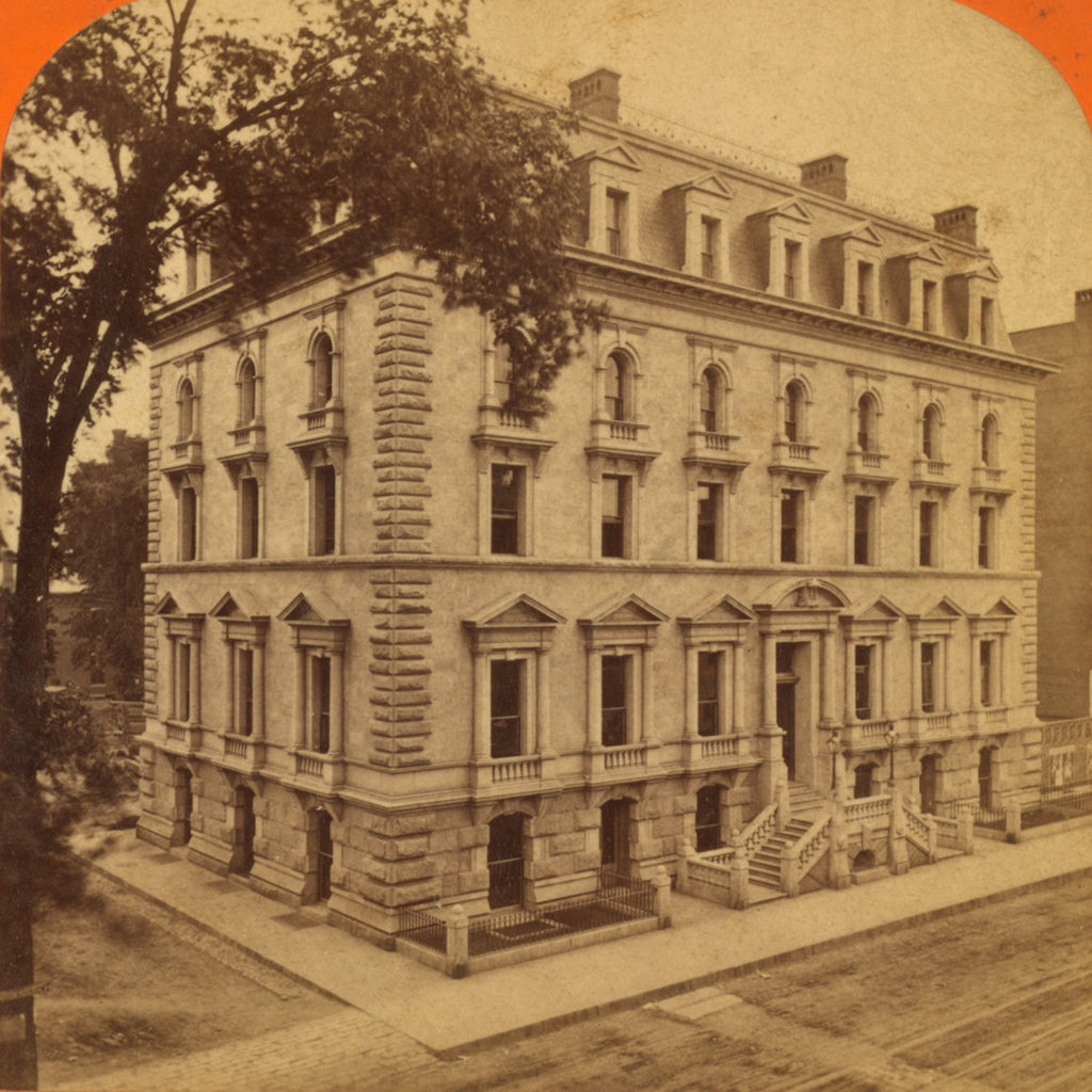
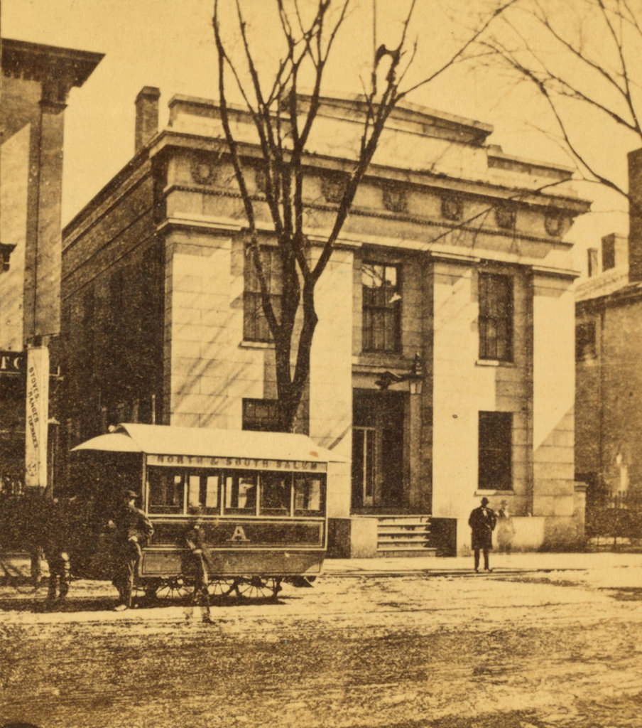
City Hall, at 93 Washington Street in Salem, around 1865-1885. Image courtesy of the New York Public Library.

City Hall in 2017:

During the early 19th century, Salem was among the largest cities or towns in the country, ranking among the top ten in the first four federal censuses. It was also the second-largest in New England during this time, behind only Boston, and in 1836 it was incorporated as the second city in the state, with a population of 15,886. At the time, the municipal government occupied the town hall at Derby Square, but construction soon began on a purpose-built city hall here on Washington Street, just north of the intersection of Essex Street.

The building, which was completed in 1838, was designed by noted architect Richard Bond, whose other Salem works included the 1854 Tabernacle Congregational Church (demolished in 1922), as well as the 1841 county courthouse on Federal Street. Bond’s design for City Hall had a Greek Revival exterior, with a granite facade on the Washington Street side and brick walls on the rest of the building. The main entrance is flanked by four Doric pilasters, supporting an entablature that features seven laurel wreaths, with a gilded eagle atop the building. On the interior, the building was constructed with city offices on the first floor, and the mayor’s office and city council chambers on the second floor.

The first mayor of Salem was Leverett Saltonstall I, a prominent politician who had previously served as president of the Massachusetts Senate and would later go on to serve in the U. S. House of Representatives from 1838 to 1843. He was also the great grandfather of Leverett A. Saltonstall, who would serve as governor of Massachusetts and as a U. S. Senator during the mid-20th century. Other notable early mayors included Stephen C. Phillips and Charles W. Upham, both of whom also served in Congress, and Stephen P. Webb, who served as mayor from 1842 to 1845 and 1860 to 1862, while in the interim serving as mayor of San Francisco from 1854 to 1855.

The first photo was taken at some point in the post-Civil War era, most likely in the late 1860s or early 1870s, and shows the front facade of City Hall, along with a horse-drawn trolley on Washington Street. The building was significantly expanded in 1876, with an addition that doubled its length, although its appearance from this angle remained unchanged. Another addition came a century later in the late 1970s, but likewise this did not affect the Washington Street side of the building.

Today, this building remains in use as the Salem City Hall, with a well-preserved exterior that shows hardly any changes from the first photo. Now over 180 years old, it is the oldest continuously-used city hall building in the state, and it survives as a good example of Greek Revival-style architecture. It was added to the National Register of Historic Places in 1973, and it is also a contributing property in the Downtown Salem Historic District.

Lyman Street Bridge, Holyoke, Mass

Looking north toward the Lyman Street bridge over the Second Level Canal in Holyoke, around 1892. Image from Picturesque Hampden (1892).

The scene in 2017:

Holyoke was developed in the mid-19th century as one of the first planned industrial cities in the country, and was powered by a network of canals that were constructed starting in 1847. The Second Level Canal, seen here, runs parallel to the city’s street grid, and it is crossed by six of the major streets in downtown Holyoke. The northernmost of these is Lyman Street, which crosses the canal here, and the first photo shows a low, two-span bridge that was probably constructed of iron. The railroad bridge just beyond it was also iron, and carried the Connecticut River Railroad through Holyoke, passing diagonally across both the canal and the intersection of Lyman and Canal Streets on the right side of the photo. This lattice truss bridge was built in 1887, and later became part of the Boston and Maine Railroad after the company acquired the rail line in 1893, soon after the first photo was taken.

Today, this scene is still easily recognizable from the first photo, although both of the 19th century bridges are gone. The old railroad bridge was replaced in 1928 by a steel Warren truss bridge, which is still in use today, and the current Lyman Street bridge was built in 2011. Further in the distance, several of the 19th century mill buildings are still standing on Gatehouse Road. The long building on the left side of the photo, once the home of the Whiting Paper Company, is still there. It was heavily altered at some point after the first photo was taken, and the right side of the building collapsed during a severe thunderstorm in 2011. However, the left side is still standing, along with the small, two-story brick building on the far left side of both photos.

Mosher Street from Main Street, Holyoke, Mass

Looking east on Moster Street from the corner of Main Street in Holyoke, around 1892. Image from Picturesque Hampden (1892).

The scene in 2017:

The railroad bridge in the foreground is located just south of Holyoke’s historic railroad station, and carries the Connecticut River Railroad over Mosher Street. This railroad line, which was acquired by the Boston and Maine Railroad soon after the first photo was taken, is the primary north-south railroad route through western Massachusetts, linking the major cities and towns of the Connecticut River Valley with Vermont to the north and Connecticut to the south.

Several blocks away in the distance of the first photo is the Church of Our Lady of the Rosary, which was built in 1887 at the northeast corner of Mosher and West Streets. It was one of many Catholic churches built in Holyoke during this time, and both the church and its parish school served the large numbers of Catholic immigrants who came to Holyoke as mill workers in the late 19th and early 20th centuries. The first pastor of the church, Michael J. Howard, died in 1888, only a year after the church building was completed, and he was succeeded by Thomas D. Beaven, who served the parish until 1892, when he became bishop of the Diocese of Springfield.

Today, only the railroad itself still exists from the first photo. The church was demolished in 1976, and the rest of the buildings between the railroad and the church are also gone. A large apartment building now dominates the left side of the 2017 photo, and the surrounding streets now consist primarily of modern duplexes, interspersed by occasional historic buildings. The old railroad station, just out of view to the left, is still standing, although it has been vacant for many years. Passenger rail was recently restored to Holyoke, with Amtrak’s Vermonter now running through the city, although it currently uses a small platform located a block south of here at Dwight Street, instead of the abandoned 19th century station.

Boston and Albany Railroad Offices, Springfield, Mass

The Boston and Albany Railroad offices, just north of the railroad tracks on Main Street in Springfield, around 1870-1885. Image courtesy of the New York Public Library.

The scene in 2017:

Henry H. Richardson was one of the most influential architects in American history, and helped to establish what became known as the Richardsonian Romanesque style of architecture. Along the way, he designed churches, government buildings, libraries, railroad stations, and private homes, but he began his career here in Springfield, where he received his first commission in 1866. Although originally from Louisiana, Richardson had graduated from Harvard, where his friends included James A. Rumrill, a Springfield resident who later married the daughter of Chester W. Chapin. Chapin, a railroad and banking executive, was among the richest men in the city, and he was also a prominent member of the Church of the Unity. Through this connection Richardson able to enter a design competition for a new church building, and his plans were ultimately selected, giving him his first commission and helping to establish his career as an architect.

Even before the Church of the Unity was completed, Richardson’s connection to Chapin helped him to obtain several more commissions here in Springfield. Among other business interests, Chapin was the president of the Western Railroad, and in 1867 Richardson was hired – without any competition – to design a building for the railroad’s headquarters here in Springfield, directly adjacent to the city’s railroad station. The result was a granite, Second Empire-style building, with a design that bore more resemblance to the fashionable townhouses of Boston’s Back Bay neighborhood than to an office building. Although hardly an architectural masterpiece, it reflected Richardson’s training at the École des Beaux Arts in France, and it showed his abilities in designing commercial structures.

Shortly after Richardson received his commission in 1867, the Western Railroad merged with the Boston and Worcester, forming the Boston and Albany Railroad, with Chapin as its president. The building was completed two years later as offices for the new railroad, and was ideally situated at the midpoint of the line, 98 miles from Boston and 102 miles from Albany by rail. Chapin went on to serve as president of the railroad for the next decade, with the line serving as an important link between Boston and the rest of the country. In 1900, it was acquired by the New York Central, but retained its separate Boston and Albany branding for many years. This building continued to be used as offices well into the 20th century, but it was finally closed in 1926 and was demolished soon after.

Many years later, this site was again used for transportation when, in 1969, the Springfield-based Peter Pan Bus Lines built its terminal here. Established in 1933 by Peter C. Picknelly, Peter Pan became a major intercity bus company in the northeast, and it has remained in the Picknelly family ever since. Peter’s son, Peter L. Picknelly, served as the company chairman from 1964 until his death in 2004, and building, which also served as the terminal for the Pioneer Valley Transit Authority buses, was named in his honor in 2005. However, in 2017, shortly after the first photo was taken, both Peter Pan and the PVTA moved across Main Street to the newly-restored Union Station, and the long-term future of this site seems uncertain at this point.

Old Union Station, Springfield, Mass

The old railroad station on Main Street in Springfield, around 1870-1885. Image courtesy of the Boston Public Library.

The scene in 2024:

Railroads first came to Springfield in 1839, with the opening of the Western Railroad from Worcester to Springfield, and the line terminated here at a wooden, Egyptian Revival-style railroad station on the west side of Main Street. The railroad was later extended west through the Berkshires, and Springfield became an important midway point on the route between Boston and Albany. The original station stood here for 12 years, but in 1851 it was destroyed in a fire after sparks from a passing locomotive ignited the building.

A new station was soon built on the same site, as seen in the first photo. Like the first station, trains passed directly through the building, although this one was less flammable, having been built with brick and iron. Architecturally, this new station was unremarkable, resembling a large shed rather than a grand union station, but it was designed by railroad engineer George William Whistler, the older brother of the famous painter James Abbott McNeill Whistler. Their father, George Washington Whistler, had briefly lived in Springfield in the early 1840s, and had been the chief engineer of the Western Railroad during the construction of route through the Berkshires.

The new station was joined in the late 1860s by a new office building for the Western Railroad, which was located just north of the station on the right side of the first photo. A striking architectural contrast compared to the plain railroad station, this granite Second Empire-style building was one of the earliest works of Henry H. Richardson, who would go on to become one of the most important architects in American history. Although very different from his later Romanesque Revival buildings, this design reflected his education in France’s École des Beaux Arts, and it helped to establish him as a notable architect.

In 1867, around the same time that Richardson received his commission for the building, the Western Railroad merged with the Boston and Worcester Railroad, forming the Boston and Albany Railroad. Both the station and the office building became part of the new railroad, but by this point it was obvious that the station, less than 20 years old, was already obsolete. As a union station, it served not just the Boston and Albany, but also the Connecticut River Railroad, and the Hartford and New Haven Railroad. Because of this, essentially all rail traffic from the four cardinal directions had to pass through this station, and Springfield’s rapidly growing population was straining the station’s capacity.

Along with overcrowding, the station’s location also caused problems, since the railroad tracks crossed Main Street just to the east of the station, as seen in the first photo. The busy railroad traffic meant that the Main Street crossing gates were closed as often as they were open, with an 1872 observer noting that the gates closed 66 times during one four-hour span from 11 a.m. to 3 p.m. This  caused a significant disruption to the busy pedestrian, carriage, and trolley traffic in downtown Springfield, but the problem persisted for several decades, with neither the city nor the Boston and Albany Railroad wanting to pay the expense of lowering the grade of Main Street or raising the grade of the railroad.

Because of this impasse, the old station remained in use well into the 1880s, since the railroad was unwilling to build a new station until the tracks were raised above street level. It was not until February 1888 that the two sides reached a compromise, with the railroad agreeing to spend $200,000 to raise the tracks and build a stone arch over Main Street, while the city would spend $84,000 to lower Main Street by four feet, and would settle any damage claims by adjacent property owners. Most significantly, though, this project meant the construction of a new railroad station, which would be built across the street from here on the east side of Main Street.

The old railroad station was demolished in the spring of 1889, but the platforms and two waiting rooms were left standing until the new station opened in July. Like the older railroad office building, the new station was based on the designs of Henry H. Richardson, although he died before construction began, and his successors made some significant alterations to his original plans. The entire project was finished once the railroad arch was completed in 1890, finally eliminating the long-problematic grade crossing on Main Street.

Despite all of these changes, the Boston and Albany office building remained standing well into the 20th century, and continued to be used even after the railroad was acquired by the New York Central in 1900. The building was finally demolished in the late 1920s, around the same time as the 1889 railroad station. Despite being less than 40 years old, this station had become obsolete as quickly as its predecessor, and in 1926 it was replaced by the current Union Station on the same site. However, the stone arch is still here, and still serves as an important downtown landmark on Main Street.

Providence River from Crawford Street Bridge, Providence, RI

Looking downstream on the Providence River from the Crawford Street Bridge, around 1906. Image courtesy of the Library of Congress, Detroit Publishing Company Collection.

1081_1906c-loc

The river from the same spot in 2016:

1081_2016
These photos show the same scene as the ones in an earlier post, just from a different angle. The “then” photos in these two photos were probably taken on the same day, too, because the same ships are docked here, in the same spots. As mentioned in another previous post, the Crawford Street Bridge was a very wide bridge that virtually buried the Providence River, hiding it from much of downtown. South of the bridge, though, the river was open, and as the 1906 photo here shows, it was filled with steamboats.

From left to right, the steamers in the photo are the Warwick, the Squantum, and the What Cheer. They were among the many that plied the waters of Narragansett Bay and beyond, providing excursion trips to Newport, Block Island, Long Island, and other destinations. By the time the first photo was taken, the steamers were already fairly old. The What Cheer was built in 1873, and the similar-looking Squantum probably dates to around the same time. The Warwick is even older; this side-wheel steamer was built in 1867. Information is scarce on the Squantum, but the other two boats operated until the early 1920s, when they were in such poor condition that the Warwick sank at the dock in 1920, and the What Cheer did the same two years later.

Today, steamboats are long gone from the waters of the Providence River, and today the only watercraft visible is a Venetian-style gondola, in the lower left center of the photo. The bridge is also gone, having been replaced by much smaller bridges that have opened up the river through downtown Providence. There are also no longer any signs warning pedestrians of the $20 fine for spitting on the sidewalk, which would have been a substantial sum of money at the time, equal to over $500 today. The only building left from the first photo is the warehouse for the Oakdale Manufacturing Company, the six-story red brick building on the left side of both photos. Built in 1854 and significantly expanded in 1894, it was home to a butter and margarine company until 1916, and later had several other industrial tenants. Today, it is part of the College Hill Historic District, and is owned by the Rhode Island School of Design.