Marlborough Street, Newport, Rhode Island

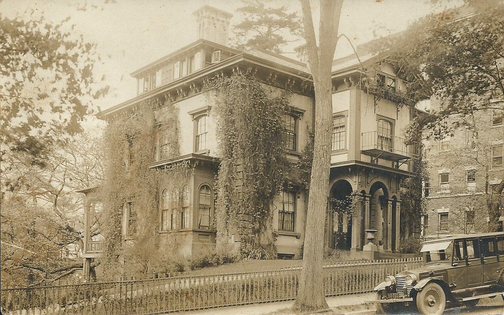
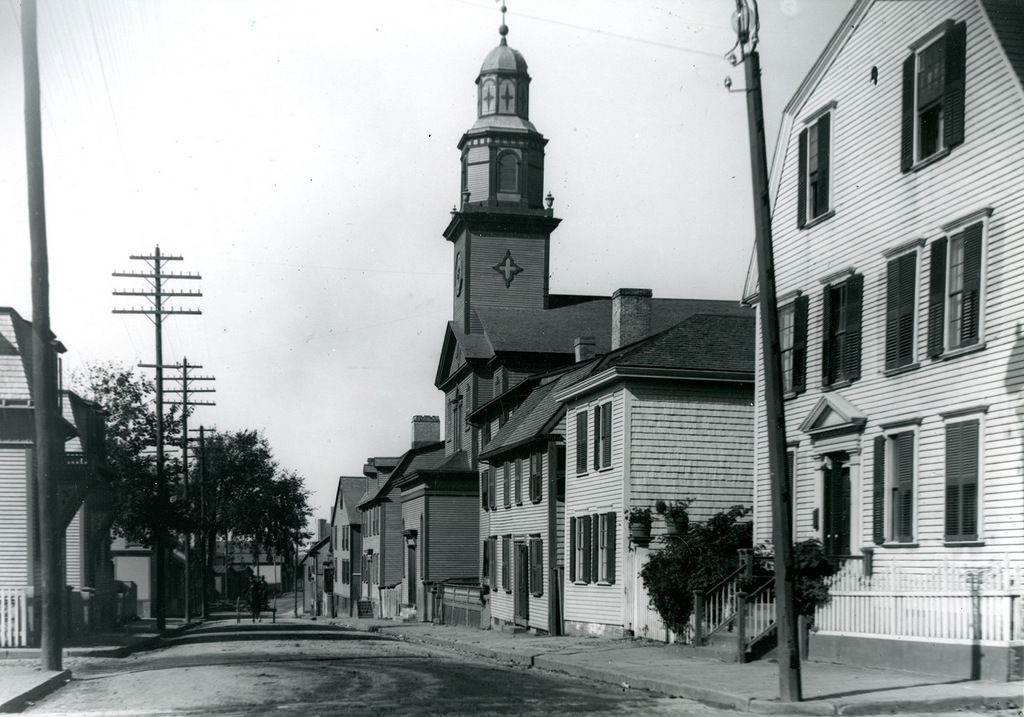
Looking west on Marlborough Street from Farewell Street in Newport, around 1911. Image courtesy of the Providence Public Library.
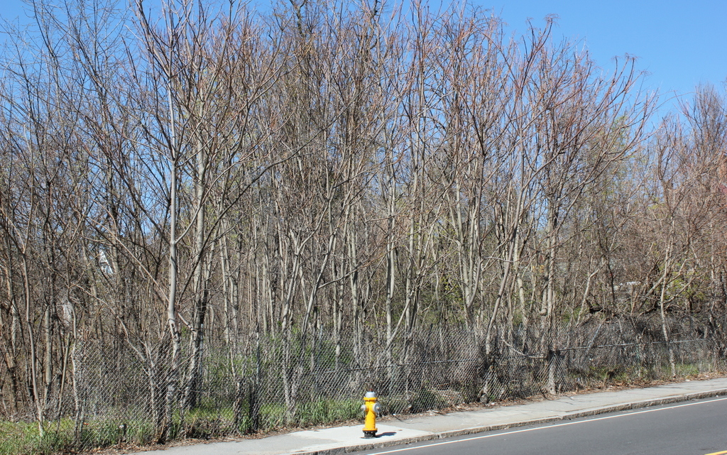
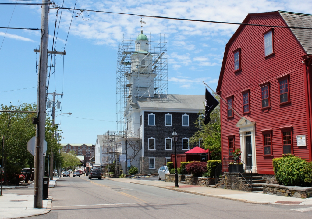
The scene in 2017:

This scene on Marlborough Street includes several notable Newport landmarks, with the most significant being the White Horse Tavern on the far right. This building is perhaps the oldest in the city, dating back to before 1673. It was just a two-story, two-room house at the time, but it was later expanded, and by 1687 it was being operated as a tavern by William Mayes, Sr. His son, William Mayes, Jr., had a career as a pirate before returning to Newport, retiring from piracy, and taking over the operation of the tavern in 1703. Within a few years, though, his sister Mary and her husband, Robert Nichols, owned the property, and it would remain in the Nichols family for nearly two more centuries.

In the years before the Colony House was built in the 1730s, the colonial legislature often met here at the White Horse Tavern, which acquired its current name around this same time. Some 40 years later, it was used to house British soldiers during the American Revolution, and after the war the building was expanded to its current size, including the addition of the large gambrel roof. It would continue to be owned by the Nichols family until it was finally sold in 1895. The first photo was taken only about 16 years later, and at this point it had been converted into a rooming house.

The White Horse Tavern was already an old building in 1807 when the other prominent landmark in this scene, St. Paul’s Methodist Church, was completed. Long known for its religious tolerance, Rhode Island was among the first places where Methodism took root in America in the late 18th century. However, the Newport congregation caused a considerable stir in the Methodist community when they built this church. Although similar to other New England churches of the era, it was far more elaborate than the plain meeting houses that early Methodists worshipped in. It is considered to be the first Methodist church in America to have a steeple, bell, and pews, and early Methodist leader Bishop Francis Asbury is said to have “lifted his hands with holy horror when he first saw it and predicted that a church which began with a steeple would end with a choir and perhaps even an organ.”

Bishop Asbury was ultimately proven right in his prediction about the organ, with the congregation installing one in the church in the 1850s. However, an even more significant change had come about 15 years earlier in 1842, when the entire building was raised eight feet and a new, full-story foundation was built beneath it to make space for a parish hall. Otherwise, the exterior of the church has not significantly changed, although the building was heavily damaged by a fire in 1881. However, it was subsequently restored, and the first photo was taken about 20 years later.

In more than a century since the first photo was taken, most of the historic buildings on both sides of Marlborough Street have been demolished. Even the White Horse Tavern itself was threatened with demolition. Badly deteriorated and neglected more than 50 years after it became a rooming house, it was nearly demolished in the 1950s to build a gas station here on the corner. Instead, though, it was purchased by the Preservation Society of Newport County, who restored it and reopened it as a tavern in 1957. It remains in operation today, and is marketed as America’s oldest tavern. Further down the street, St. Paul’s Methodist Church is also still standing, and still houses the same congregation. The 2017 photo shows it in the midst of a restoration project, but otherwise it is largely unchanged from the first photo, and both it and the White Horse Tavern are now contributing properties in the Newport Historic District, which is a National Historic Landmark district.

Samuel Bowles House, Springfield, Mass

The house at 182 Central Street in Springfield, probably sometime around 1910-1920. Image courtesy of Jim Boone.

The house in 2017:

This elegant Italianate-style home was built in 1853, along the slope of Ames Hill near the corner of Maple and Central Streets. It was designed by Henry A. Sykes, an architect from Suffield, Connecticut, whose other Springfield works included the Mills-Stebbins Villa on nearby Crescent Hill, and it was originally owned by Francis Tiffany, the pastor of the Church of the Unity. Reverend Tiffany had become the pastor of the church in 1852, and he would go on to serve the congregation for the next 12 years. He and his wife Esther lived in this house throughout this time, and by the 1860 census they were living here with four young children.

In 1864, Tiffany left the church to take a position as an English professor at Antioch College in Ohio, and he sold the house to Samuel Bowles, who was a friend of his and one of the most influential men in the city. He was the son of Samuel Bowles II, a journalist who had founded the Springfield Republican as a weekly newspaper in 1824. The younger Samuel was born two years after the paper started, and began working alongside his father when he was 17. Around the same time, the Republican became a daily newspaper, and after his father’s death in 1851, Samuel took over control of the paper, when he was just 25 years old.

By the time Samuel Bowles and his wife Mary moved into this house, the Republican was one of New England’s leading newspapers, and as the name of the paper suggested, it generally supported Republican, anti-slavery policies before and during the Civil War. Bowles was also a friend of Emily Dickinson, and he published several of her poems in the Republican. These poems, which were heavily edited in order to conform with conventional poetic styles, were among the very few that were ever published during her lifetime, as most of her nearly 1,8000 poems were discovered and published posthumously.

Samuel and Mary Bowles raised ten children in this house, although during this time he frequently traveled. He suffered from poor health, which was attributed to over-working, so because of this he took a number of trips to the American West and to Europe in the 1860s and early 1870s, often publishing accounts of his travels. However, he died in 1878, at the age of 51, and the responsibility of running the newspaper fell to his son, Samuel Bowles IV, who was 26 years old at the time, just a year older than his father had been when he took over the paper in 1851.

By the end of the 19th century, the house had become part of the MacDuffie School, which had been founded in 1890 by John and Abby MacDuffie as a school for girls. The Bowles house became the school’s main classroom building, but over time the campus expanded, eventually encompassing many of the historic mansions on and around Ames Hill. The house became part of the Ames/Crescent Hill Historic District when it was added to the National Register of Historic Places in 1974, but in 1978 the school requested permission from the Historical Commission to demolish the house, claiming that it was in poor condition and that the land was needed for tennis courts. The Commission ultimately granted the request, and despite a court challenge by local preservationists, the house was demolished in 1980. However, the tennis courts were never built, and the site of the house remains vacant nearly 40 years later.

Grenada Terrace, Springfield, Mass

Looking east on Grenada Terrace from Dickinson Street in Springfield, sometime in the early 1900s. Image courtesy of Jim Boone.

The scene in 2017:

The Forest Park neighborhood of Springfield was very sparsely developed up until the 1890s, when trolley lines were built through the area, providing a direct connection to downtown Springfield. This section of Forest Park, just to the northeast of the “X”, was developed by the Sumner Avenue Heights Company, and featured streets with names associated with warm climates, such as Ventura, Sorrento, and Pomona. The centerpiece of this development was Grenada Terrace, which was built parallel to Sumner Avenue and featured a wide street with a landscaped median.

The street itself was laid out by the late 1890s, but none of the houses were built until the first decade of the 20th century. Nearly all of the homes had been completed by 1910, and the first photo was probably taken around this time. Most of these homes were owner-occupied, and the 1910 census shows residents with a wide range of middle-class professions, including a clerk, contractor, building inspector, stenographer, traveling salesman, and an Armory employee.

A century later, nearly all of these homes are still standing, although most have been altered with modern changes such as enclosed porches and artificial siding. Two brick apartment buildings, visible in the distant left of the 2017 photo, were built in the 1910s, but the neighborhood remains predominantly single-family, two-family, and three-family homes. Otherwise, the only significant change to this scene is the left side, where four of the homes were demolished to make a parking lot for the Holy Name Church, which is partially visible on the far left.

Westminster Street from State Street, Springfield, Mass

Looking north on Westminster Street from State Street in Springfield, probably around 1900-1920. Image courtesy of Jim Boone.

The scene in 2017:


About 50 years before the first photo was taken, this section of State Street was only sparsely settled, with very little development to the east of the Armory. This site here, on the north side of State Street, was the approximate location of a farmhouse that was owned by Josiah W. Flagg, who owned 22 acres of land behind the house. Located about a mile and a half from Main Street, and separated from it by a steep hill, this part of the city was hardly desirable real estate, but this began to change in 1870, when the Springfield Street Railway began operation, with a horse-drawn trolley line extending as far as Oak Street.

That same year, dry goods merchant John McKnight entered the real estate business, and purchased the Flagg farm. Along with his brother William, he subdivided the property and laid out four streets between State and Bay Streets, including Westminster Street, as seen here. Thanks in part to the economic recession following the Panic of 1873, development was slow for the first decade or so, but it construction of new homes picked up in earnest by the early 1880s. Most of the houses on this block of Westminster Street were built between 1880 and 1891, with Queen Anne style architecture that appealed to popular tastes of the era.

In contrast to the modest, middle class homes on the side streets, the houses on State Street were much larger, and were built for some of the city’s most prominent residents. The house on the far left of this photo was built for William McKnight in the early 1870s, although he later moved to a different house on Worthington Street. On the opposite side of the photo, this house was built in 1871 for insurance agent Henry K. Simons. However, the house was later remodeled in 1894 for Noyes W. Fisk, an industrialist who worked as the clerk and treasurer of the season Manufacturing Company, and later established the Fisk Rubber Company. The house’s large gambrel roof was probably added during this renovation, and it disguises the fact that the house is actually several decades older than it appears.

About a century after the first photo was taken, much of the McKnight neighborhood remains remarkably well-preserved. However, this section of Westminster Street has lost a number of houses over the years, particularly on the left side of the street. The old William McKnight house on the far left was demolished around the early 1920s to build and an automobile service station that is still standing today. Just beyond it, two highly ornate Queen Anne-style homes have also been demolished, and were replaced with plain multi-family homes.

Further down the street, there are other vacant lots where houses once stood on both sides of the street, but many of the historic homes are still standing, including most notably the house on the far right. Now a funeral home, it is one of the last of the 19th century mansions on State Street, and despite the 1890s alterations it is also one of the oldest homes in the McKnight neighborhood. Today, this neighborhood consists of some 800 historic homes from the late 19th and early 20th century, and they now form the McKnight Historic District on the National Register of Historic Places.

Forest Park Avenue, Springfield, Mass

Looking south on Forest Park Avenue from near the corner of Randolph Street in Springfield, sometime in the early 1900s. Image courtesy of Jim Boone.

The scene in 2017:


For most of the 19th century, the area that would become Springfield’s Forest Park neighborhood was only sparsely settled. However, with the opening of a trolley line to the area in 1890, the southwestern corner of the city suddenly became within easy commuting distance of downtown Springfield. One of the first developers in the neighborhood was the Mutual Improvement Company, which purchased much of the land in the large triangle between Fort Pleasant, Belmont, and Sumner Avenues. A number of new streets were laid out, including Forest Park Avenue, which is seen here near the center of the development.

The Mutual Improvement Company was founded by John and William McKnight, the brothers who had been developing Springfield’s McKnight neighborhood since the 1870s. Like in McKnight, they sought to create an upscale residential neighborhood here in Forest Park that would appeal to Springfield’s leading citizens. Nearly all of the houses were unique, and were designed by some of the city’s leading architects. They also sold undeveloped lots, although these deeds came with restrictive covenants that required a specific setback from the road and a minimum construction cost.

Development in this section of Forest Park began in the early 1890s, primarily in the area between Garfield Street, Churchill Street, Sumner Avenue, and Forest Park Avenue. A few of these homes are visible in the distance, and they tend to have Queen Anne-style architecture, which was popular in the last decades of the 19th century. However, the large-scale development of this area did not begin until after 1900. At this point, architectural tastes had shifted toward Colonial Revival, as can be seen in the house on the far left, which was built in 1902. Other buildings that were completed during this second phase include the 1901 Park Memorial Baptist Church, which is visible in both photos.

About a century after the first photo was taken, the Forest Park Heights neighborhood remains remarkably well-preserved, and very little has changed in this scene on Forest Park Avenue. The only significant difference is the house on the right side of the first photo, at the corner of Garfield Street. It was built in the early 1890s, and was the home of candy manufacturer Franz Jensen. However, it was demolished in the 1930s, and was later replaced by a smaller Cape-style home in the 1940s. Overall, though, most of the historic homes in this neighborhood have survived with few major changes, and in 1982 the area was added to the National Register of Historic Places as the Forest Park Heights Historic District.

Maple Street, Springfield, Mass

Looking north on Maple Street from the corner of Mulberry Street in Springfield, sometime around the early 1900s. Image courtesy of Jim Boone.

The scene in 2017:


In the second half of the 19th century, the section of lower Maple Street between State Street and Central Street featured some of the finest homes in the entire city. Most of these homes are now gone, but the first photo shows the street as it appeared around the turn of the 20th century, when many of Springfield’s prominent residents lived here. The four houses seen here, between Mulberry and Union Streets, were built in the late 1800s, and were, starting in the foreground, house numbers 127, 111, 95, and 89.

At the corner of Mulberry Street was 127 Maple Street, which was the home of Charles Marsh, the president of Pynchon National Bank. By the early 1900s, it was owned by James F. Bidwell, a tobacco dealer who held several municipal offices, including serving as a city alderman and as a water commissioner. To the left of his house was 111 Maple Street, the home of Eunice B. Smith, an elderly widow whose husband, David, had been a physician. The third house, 95 Maple Street, was the home of Eunice’s brother, James D. Brewer, and was later owned by his daughter Harriet and her husband, Dr. Luke Corcoran. The fourth house, 89 Maple Street, is barely visible at the corner of Union Street, and was the home of Henry A. Gould, a paper manufacturer.

All four of these homes survived well into the 20th century, but they were all demolished by 1965, when the current building was built on the site. It was originally offices for the Insurance Company of North America, but it was later sold to the Milton Bradley Company, who used it as their corporate offices. However, in 1984 Milton Bradley merged with Hasbro, and the following year its offices were moved to East Longmeadow, leaving this building vacant. In the early 1990s, it was sold to the city, expanded, and is now the Milton Bradley Elementary School.