Old Meeting House, South Hadley, Mass

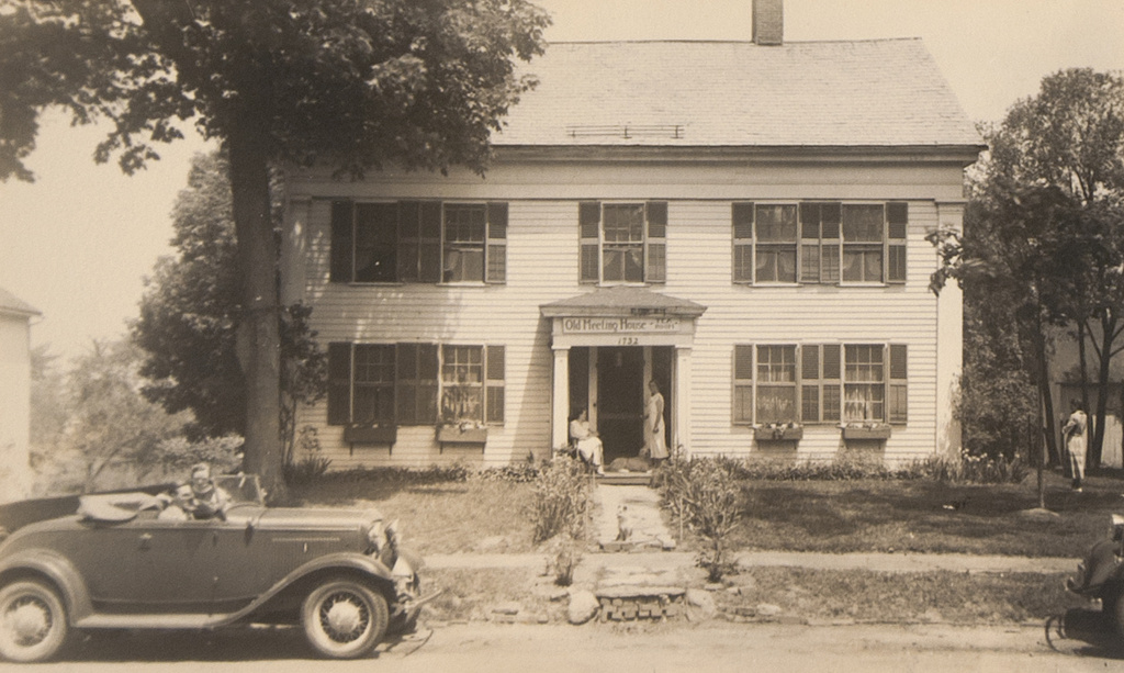
The Old Meeting House at the northern end of the town common in South Hadley, around 1930-1937. Image courtesy of Mount Holyoke College Archives and Special Collections.
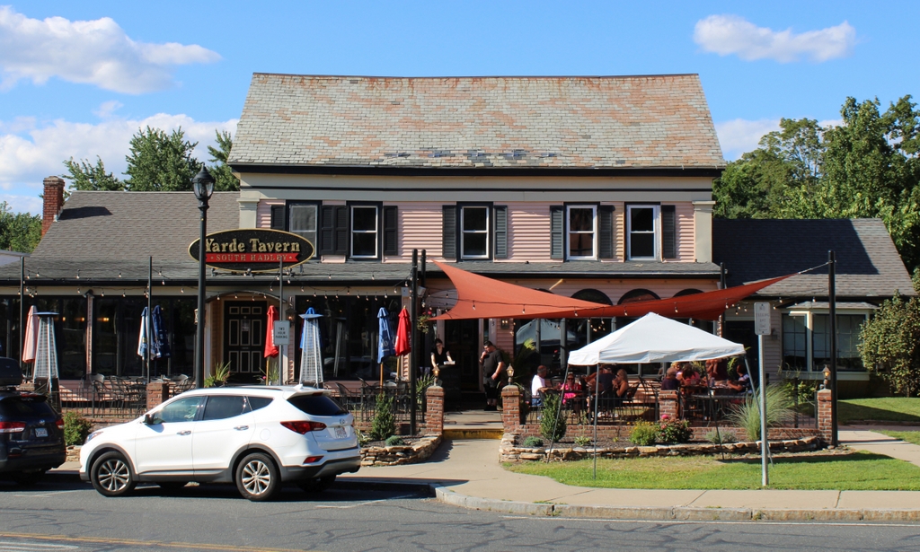
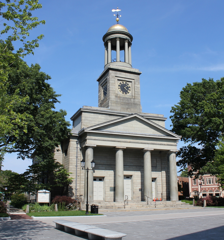
The scene in 2023:

Although it is difficult to tell from its current appearance, this modest-looking colonial house is actually the original meetinghouse in South Hadley. It was built around 1732, when South Hadley was still a part of Hadley, and it is likely the oldest surviving church building in western Massachusetts. It is also one of the oldest in the entire state, dating back to a time when New England meetinghouses were typically built without steeples or bell towers.

European colonists settled in present-day South Hadley around the 1720s. These early residents would have been expected to attend church and town meetings in Hadley, but this proved challenging. The town center was eight miles away along rough roads, and South Hadley was geographically isolated from the rest of the town by Mount Holyoke. As a result, the settlers soon requested a church of their own, which was established around 1732. This meetinghouse was constructed around this time, and the building was originally situated about 100-150 feet south of its current location, on what is now the town common.

The first meeting appears to have been held here in March 1733, and the first pastor of the church was Grindall Rawson, who was ordained on October 3, 1733. He was a recent Harvard graduate who was about 25 years old, and five years later he married Dorothy Chauncey, the daughter of Reverend Isaac Chauncey of the Hadley church. During this time, work continued on the interior of the meetinghouse. This was done in several stages, beginning with the installation of nine pews in 1733, and it was not completed until 1744, when the gallery was finished.

It was not uncommon for early 18th century pastors to remain with the same church for their entire ministry career, but this ultimately was not the case for Reverend Rawson. Described in the 1863 History of Hadley book as “eccentric, free-spoken, and rash,” he soon became a source of controversy here in South Hadley. In 1737 a council of local clergymen met to discuss Rawson. Few details survive from this meeting, including where it was held, but one of the attendees was Jonathan Edwards, the famous pastor of the church in Northampton. He served as the scribe of the meeting, and in his memoirs he later wrote that the question at hand was “Whether Mr. R. was qualified for the work of the ministry as to his learning, his orthodoxy and his morals.” The council apparently found no issues with his qualifications, but this did little to appease his parishioners.

In February 1740, the congregation voted in favor of dismissing Rawson. However, he remained in that position for more than a year before, in March 1741, the church reaffirmed their decision and declared that “we have no further service for him in the office of a gospel minister, and that we expect he will refrain from any public acts in that office among us.” Rawson was apparently unfazed by this, though, and he continued to conduct services from the pulpit here throughout much of 1741. Finally, in October the church passed a resolution stating:

As Mr. Rawson has lately in an abrupt manner entered the meeting house and performed divine service, contrary to the mind of this precinct, the committee are directed and empowered to prevent Mr. Rawson from entering the meeting house on the Sabbath, by such means as they shall think best, except he shall promise not to officiate or perform service as a minister, and if Mr. Rawson shall offer to perform service as a minister, the committee shall put him forth out of the meeting house.

This still did not stop Rawson, who took to the pulpit a few weeks later. This time, though, a group of men seized him and forcibly carried him out of the building. The parish subsequently voted to appropriate 10 pounds as a legal defense fund, in the event that Rawson pressed charges against the men involved, but he did not, nor did he make any further attempts to preach here. He did, however, continue to live here in South Hadley for three more years, before accepting a position as pastor of a church in Hadlyme, Connecticut, where he served until his death in 1777.

In the meantime, South Hadley continued to grow in population, and this meetinghouse soon became too small for the parish. As early as 1751 the congregation voted to build a new church, but this caused a new controversy regarding its location. The residents here in the western part of the parish favored a site near the existing meetinghouse, while those in the eastern part—in present-day Granby—wanted the new church in a more central location on Cold Hill. After a decade of wrangling, the western faction finally prevailed, and the new church was built nearby in 1762. That same year, the eastern half of the district was established as a separate parish, and in 1768 it was incorporated as the town of Granby.

In the meantime, once the new church was completed the old building was moved northward to its current location, and it was converted into a house. This was a typical practice in New England during the 18th and 19th centuries, with thrifty Yankees generally preferring to move and repurpose old buildings instead of demolishing them. In the case of this meetinghouse, its relatively small size for a church—only 40 feet by 30 feet—made it well-suited for use as a house.

It is difficult to trace the ownership of the building in the early years after conversion to a house, but at some point in the first half of the 19th century it was owned by the Goodman family. It was then owned by Alfred Judd, who had been living there for “many years” by the time the History of Hadley was published in 1863. In a footnote, the author remarked that it was a “comely dwelling,” and that its old frame “may yet last a century.” More than 150 years later, this prediction that has proven to be a significant underestimate of the building’s longevity.

The 1860 census shows Alfred Judd living here with his daughter Irene, her husband Joseph Preston, and their two young children, Alfred and Joseph Jr. Alfred was 62 years old at the time, and he had just recently been widowed after his wife of 38 years, Mary, died in February 1860. He subsequently remarried to Sophia Preston in 1861, and he appears to have lived here until his death in 1878.

At some point afterward, Judd’s grandson Joseph Preston Jr. purchased the property to the right of the family home and built the Hotel Woodbridge, which later became Judson Hall, a dormitory for nearby Mount Holyoke College. In the meantime, the old house remained in the Preston family for many years. Joseph Jr. died in 1922, but his widow Elmina continued to own it until at least the 1930s, although it seems unclear as to whether Joseph or Elmina actually lived here during the early 20th century, or simply rented it to other tenants.

In any case, the first photo was taken at some point during Elmina’s ownership in the 1930s. By then, the building was the home of the Old Meeting House Tea Room, as indicated by the sign above the front door. It is difficult to determine exactly how much its exterior appearance had changed by this point, but it was clearly different from how it would have looked when it was moved here in the early 1760s. In particular, the wide pediment just below the roof and the pilasters in the corners are most certainly not original; these would have probably been added around the early 19th century, giving the old colonial meetinghouse a vaguely Greek Revival appearance.

In more than 80 years since the first photo was taken, this building has undergone some significant changes, including additions to the left, right, and behind the original structure. The front of the building has also been altered, particularly on the ground floor, but overall it is still recognizable from the first photo. Throughout this time, it has continued to be used as a commercial property, and it is currently the Yarde Tavern restaurant. The second floor of the building was damaged by a fire in April 2019, but the building survived and the restaurant itself was only closed for a few weeks.

Today, the building bears almost no resemblance to the Puritan meetinghouse that Grindall Rawson was dragged out of nearly 280 years ago. However, it despite these changes it still has significant historic value as one of the oldest buildings in South Hadley, in addition to being one of the few surviving early 18th century church buildings in this part of the state.

Judson Hall, South Hadley, Mass

The view looking north on College Street toward the intersection of Hadley Street in the center of South Hadley, around 1912. Image from In Old South Hadley (1912).

The scene in 2019:

The first photo was taken sometime in or before 1912, and it shows Judson Hall, a dormitory for students at nearby Mount Holyoke College. This building was originally constructed in the late 19th century as the Hotel Woodbridge, which was owned by Joseph S. Preston Jr. References to the hotel first appear in local newspapers around 1896, and it appears to have been in business for about a decade or so. Most of these newspaper advertisements mention the hotel’s “spacious piazzas,” which ran along the south and east sides of all three stories, and an 1898 ad lists the rates as ranging from $8 to $14 per week.

The hotel was temporarily used to house Mount Holyoke students in 1896, after the main college building was destroyed in a fire on September 27. Then, in 1908 the college purchased the hotel and renamed it Judson Hall in honor of Judson Smith, who had served as president of the board of trustees from 1894 until his death in 1906. It was subsequently used as a dormitory for the next 24 years, before being closed in 1932.

Judson Hall was demolished two years later, and the property was sold to the federal government to construct a post office here. The loss of the old hotel-turned-dormitory was evidently seen as an improvement by many people at the time, including the Springfield Republican, which wrote in 1934 that “Not only has it proved inadequate as a residence and inappropriate for business activities, but also its style of architecture has disturbed the harmony and beauty of South Hadley for many years.”

Today, the post office is still standing here in the center of this scene, and the only surviving building from the first photo is the one on the far left. Although it looks like an ordinary colonial-era house, it was actually built around 1732 as South Hadley’s first meeting house. It was only used as a church for a few decades though, before it was replaced by a new larger church in 1764. The old building was then moved here to this site and converted into a house, and more recently it has been occupied by a number of different restaurants. It is currently the Yarde Tavern, and despite the many alterations it is perhaps the oldest surviving church building in western Massachusetts.

Mount Holyoke Summit, Hadley, Mass

A group of visitors sitting on the rock ledges near the summit of Mount Holyoke in Hadley, around the 1860s or 1870s. Image courtesy of the New York Public Library.

The scene in 2019:

As discussed in the previous post, Mount Holyoke is a traprock mountain on the Metacomet Ridge, which runs roughly south to north from Long Island Sound to near the Massachusetts-Vermont state line. Although relatively low in elevation compared to the mountains of the nearby Berkshires, the ridge runs through the middle of the Connecticut River Valley providing dramatic views from atop the steep rocky cliffs. At 935 feet in elevation, Mount Holyoke is a few hundred feet lower than the highest peaks on the ridge, but it offers perhaps the most impressive views of any mountaintop in southern New England. Here, the Connecticut River flows through a narrow gap between Mount Holyoke to the east and Mount Nonotuck to the west, and the river is visible for miles in both directions.

The river takes a meandering course through the flat river valley to the north of Mount Holyoke. The most famous of these meanders is the Oxbow, a three-mile-long U-shaped bend in the river at the base of the mountain. This prominent natural feature was the focal point of Thomas Cole’s 1836 painting The Oxbow, which portrays the scene from near this spot at the summit. His work went on to become one of the most important 19th century American landscape paintings, but the actual view here from Mount Holyoke changed dramatically only a few years later. In 1840, a flood cut through the narrow neck of land in the middle of the bend, and the main current of the river shifted to the new shorter route, turning the Oxbow into a side channel.

The first photo was taken only a few decades later, and it shows the wide river passing through the lower right side of the scene, with the circular Oxbow beyond it in the distance. By this point, Mount Holyoke was a popular destination for visitors, including the well-dressed group of women sitting on the rocks in the foreground. Directly behind them, barely visible on the far left side, is the corner of the Summit House, also known as the Prospect House. This hotel was built in 1851, replacing an earlier building on the site, and it provided accommodations and refreshments for guests who either hiked up or took the inclined railway to the summit. The man in the center of the photo could very well be hotel owner John French or one of his employees, as the hotel provided telescopes for mountaintop visitors.

The hotel steadily expanded during the second half of the 19th century, and at some point a porch was added to the northern side of the building, as shown in the present-day photo. However, by the early 20th century mountaintop hotels had passed their heyday. Thanks to modernization efforts of Holyoke silk manufacturer Joseph Skinner, the Summit House remained viable for many years, but it ultimately closed after sustaining heavy damage in the 1938 hurricane. A large wing of the building, which had been added in 1894, was demolished after the hurricane, and in 1939 the property was donated to the state, becoming the Joseph Allen Skinner State Park.

Today, this scene at the summit of Mount Holyoke is still easily recognizable from the first photo, despite a conspicuous lack of women in hoop dresses. The Summit House is still standing, after having been restored in the 1980s, and it is now open seasonally as a museum. Further in the distance, the Oxbow is still there, although somewhat less prominent than in the first photo.

Part of the reason for this might be because of the increased tree growth along its banks, but also because the Oxbow has been heavily altered in the 20th century. It is now closed off from the upstream side, with only a narrow channel on the downstream side to link it to the Connecticut River. Along with this, Interstate 91 now passes directly over it, and a large chunk of the land inside the curve has been carved out to create a marina. As a result, it bears little resemblance to the undisturbed natural feature that Cole painted nearly 200 years ago, but it remains an important landmark that has long been associated with this view from Mount Holyoke.

Connecticut River and Mount Tom from Mount Holyoke, Hadley, Mass

The view looking south from the Mount Holyoke Summit House in Hadley, around 1900. Image courtesy of the Library of Congress, Detroit Publishing Company Collection.

The scene in 2019

One of the most important geological features in the Connecticut River Valley is the Metacomet Ridge, a long narrow traprock formation that runs roughly parallel to the river. It passes through central Connecticut and western Massachusetts, running from Long Island Sound to just south of the Vermont border. Its peaks are relatively low in elevation compared to the mountains of the Berkshires further west, with few reaching above a thousand feet, but the ridge stands out in the landscape because it rises so high above the surrounding low-lying river valley.

Because of this prominence, the Metacomet Ridge offers expansive views from atop its steep traprock ledges. However, perhaps none of these views are as celebrated as those from Mount Holyoke, which sits on the border of Hadley and South Hadley, Massachusetts. The 935-foot mountain is in the middle of a ten mile section that features some of the highest elevations of the entire ridgeline. This section is bookended by the two highest peaks of the Metacomet Ridge, with the 1,200-foot Mount Tom at the southern end and the 1,106-foot Mount Norwottuck to the east.

Although Mount Holyoke is comparatively lower in elevation, it has a unique position. Here, the ridge takes a sharp 90-degree turn across the Connecticut River, forming two perpendicular ranges bisected by the river. Mount Holyoke is located directly east of the river, so the top of the mountain provides dramatic views of the river as it winds its way through the surrounding farmland. Most famously, these scenes inspired 19th century artist Thomas Cole to paint The Oxbow, one of the most iconic landscape paintings in the history of American art.

The view captured in The Oxbow is not the same direction as the two photos shown here in this post. Cole’s painting faces almost due west, while these two photos were taken facing south, looking downstream on the river with the city of Holyoke in the distance on the left and Mount Holyoke on the right. Unlike the views to the west or north from the summit, this southern view is not nearly as celebrated in paintings or photographs. Part of this might be because the viewer is typically facing into the sun in this direction, creating a backlit scene. Another reason might be because the mountain has a much more gradual southern slope, so the landscape seems more distant when compared to the views from atop the steep northern and western cliffs.

Either way, the scene in the first photo shows some interesting contrasts. The jagged spine of the Metacomet Ridge runs across the horizon of the photo, parallel to the gently curving Connecticut River in the center of the scene. Further to the left, the prosperous industrial city of Holyoke in the distance contrasts with the open fields and scattered farmhouses of the foreground. The view is somewhat different in the present-day scene, as the trees now obscure most of the foreground, but both the river and the ridgeline remain dominant features in the landscape.

Both of these photos were taken from the porch of the Summit House, which was built in 1851 and expanded several times in the second half of the 19th century. At the time, mountaintop resorts were particularly popular, and the Summit House here on Mount Holyoke was just one of three in the vicinity; the others included the Eyrie House atop Mount Nonotuck, and the Summit House on Mount Tom, which is visible in the distance on the right side of the first photo.

It is difficult to tell, but the Mount Tom building in the photo appears to have been the first of three successive ones at the summit. This one burned in 1900, probably soon after the photo was taken, and it was subsequently rebuilt twice in the early 20th century. The Eyrie House likewise burned in 1901 and was never rebuilt, yet the Mount Holyoke hotel has managed to avoid such a fate, and the building is still standing today as a museum.

More than a century after the first photo was taken, and nearly two centuries after Thomas Cole made the mountain famous, much has changed in the view from Mount Holyoke. The land is actually far more forested now than it was at the turn of the 20th century, so in some ways there are actually fewer obvious signs of human development. However, the abundance of trees also makes very clear the swath that Interstate 91 cuts across the modern-day landscape, about halfway between the river and the mountains.

Despite these changes, though, the view from Mount Holyoke remains perhaps the most impressive landscape view in southern New England. Although overnight guests no longer stay at the Summit House, the mountain remains a popular destination, with visitors driving up the auto road or climbing the relatively short hike from the base. In 1939, the summit and the surrounding land became the Joseph Allen Skinner State Park, after its namesake donated the land to the state. Much of the remaining land along the Holyoke and Mount Tom ranges has similarly been preserved, and the area affords some of the best hiking and other outdoor recreation opportunities in the Connecticut River Valley.

Thomas Crane Public Library, Quincy, Mass

The Thomas Crane Public Library on Washington Street in Quincy, around 1900-1906. Image courtesy of the Library of Congress, Detroit Publishing Company Collection.

The library in 2019:

The Thomas Crane Public Library was established in 1880 by Albert Crane as a memorial to his late father, Thomas Crane. Born in 1803, Thomas grew up in Quincy and began working here as a stonecutter in the granite quarries. He later moved to New York, where he had a successful business career selling Quincy granite in the rapidly-growing city. However, he did not forget Quincy, often spending his summers here, and after his death in 1875 his son decided that a public library would be an appropriate way of honoring his memory.

The building was designed by Henry H. Richardson, one of the nation’s preeminent architects of the 19th century. Richardson pioneered a style known as Richardsonian Romanesque, which typically featured rounded arches, tall narrow windows, and rough exterior walls with contrasting light and dark stone. The vast majority of Richardson’s works were public buildings, including a number of churches and railroad stations, and he also designed several libraries. Despite its relatively small size, this library is generally regarded as one of his finest works, with architectural historian and Richardson biographer Henry-Russell Hitchcock declaring it to be “without question the best library Richardson ever built.”

The library was completed in 1882, with the formal dedication on May 30. Albert Crane and other members of his family attended the event, and he ceremonially handed over the keys of the building to Charles Francis Adams Jr., the grandson and great grandson of Quincy’s two famous presidents. Adams then gave the keynote address, in which he recounted the life of Thomas Crane, with a particular emphasis on his humble origins and his strong personal character and morals.

The building’s architecture was well received, and the Boston Journal published a glowing review of its design as part of its coverage of the dedication ceremony:

It is built in what may be termed free Romanesque style of architecture, and is in the form of a parallelogram, 84 by 41 feet in dimensions. The outer material is of Easton pink-tinted granite trimmed with Longmeadow brown stone. The interior above the basement is occupied by one lofty story and a low studded attic. The southern portion is devoted to a reading room. There are in the large hall 16 alcoves with a capacity of 40,000 volumes, and a small room is specially devoted to books and manuscripts pertaining to local history. The effect of the interior is pleasing. There are seven large windows beautifully decorated in stained glass by La Farge. In the east window of the reading room are the suggestive words; “And his leaves shall not wither.” The principal light is a remarkable piece of work, the design of which is by La Farge, and represents in vivid hues an old philosopher holding a roll in his hand. The finish of the interior is of Southern pine, beautifully decorated. The cost of the structure was $40,000, and the expense of grading and embellishing the grounds will probably reach $10,000 or $15,000 additional.

Despite the large capacity of the original library building, though, it was soon in need of expansion. The first addition came in 1908, with a wing in the rear of the library. Richardson had died more than 20 years earlier, but one of his former employees, William Martin Aiken, designed the addition, which matched the appearance of the original building. A second, more substantial expansion came in 1939, with the construction of a new building immediately to the southeast, connected to the older building by an L-enclosed walkway that is partially visible on the far right side of the present-day scene. As with Aiken’s wing, the architecture of this addition copied Richardson’s style. Then, the last expansion occurred in 2001, with a substantial addition to the east of the 1939 wing that doubled the size of the library.

Today, despite these many additions, the original 1882 Richardson portion of the library has remained essentially unchanged from this view. Its surroundings have changed, and the tower of the 1927 Bethany Congregational Church now looms above the building in the distance, but the old library has survived as an important work by one of the greatest architects in American history. Because of its architectural significance, the library was added to the National Register of Historic Places in 1972, and 15 years later it was designated as a National Historic Landmark, the highest level of federal recognition for a historic property.

United First Parish Church, Quincy (2)

The United First Parish Church on Hancock Street in Quincy, around 1865-1885. Image courtesy of the New York Public Library.

The church in 2019:

Quincy’s United First Parish Church was previously featured in one of the first blog posts on this site, which shows the building from the southwest corner. These two photos here show a similar view of the church, but from the northeast side, from directly in front of Quincy City Hall.

The church was completed in 1828, and it is constructed of locally-quarried Quincy granite, most of which was taken from quarries owned by the Adams family. It features a Greek Revival-style design that was common for New England churches of the era, including columns and a portico at the main entrance, and a multi-stage steeple above it. The design was the work of prominent Boston architect Alexander Parris, who is perhaps best remembered for Quincy Market, which had been completed two years before the church and shares some similar design elements.

At the time of its completion, the most notable parishioner of this church was President John Quincy Adams, whose family had help to finance its construction. His father, President John Adams, had also been a member of the same congregation, although he died in 1826, a year before construction began on this building. Both John and Abigail Adams were subsequently interred here in 1828, in a crypt beneath the church. Then, in 1852, John Quincy Adams and his wife Louisa were also interred in the crypt, giving the church the unusual distinction of being the final resting place of two United States presidents.

The church was formally dedicated on November 12, 1828, less than two weeks after John Quincy Adams lost his re-election bid to Andrew Jackson. Contemporary newspaper accounts observed that the crowd at the dedication ceremony was smaller than expected due to the “uncommon tempestuousness” of the weather, but the Boston Courier nonetheless noted that:

The house was well filled, and the exercises were such as might be expected from the gentlemen who took part in them. The choir were well versed in their pieces, and performed with gratifying precision.

A number of local clergymen participated in the ceremony, and Quincy’s own pastor, the Reverend Peter Whitney, gave the sermon on Genesis 28:17, “This is none other but the house of God, and this is the gate of heaven.” Among the hymns was one written by noted Boston poet and clergyman John Pierpont, who is probably best remembered today as the grandfather and namesake of Gilded Age financier John Pierpont Morgan. Reverend Pierpont’s hymn included many references to the late John Adams, particularly the final two stanzas, which read:

Here the water of salvation
Long hath gushed a liberal wave;
Here, a Father of our nation
Drank, and felt the strength, it gave.
Here he sleeps, his bed how lowly!
But his aim and trust were high;
And his memory, that is holy;
And his name, it cannot die.

While beneath this Temple’s portal
Rest the relics of the just,
While the light of hope immortal
Shines above his sacred dust,
While the well of life its waters
To the weary here shall give,
Father, may thy Sons and Daughters
Kneeling round it drink and live!

The first photo shows the church as it appeared sometime during the second half of the 19th century, probably around the late 1860s or 1870s. Since then, there have been some changes to this scene. The building in the distant right of the first photo was demolished at some point in the late 19th or early 20th centuries, and in 1924 the old Quincy Patriot Ledger building was constructed on the site. More recently, in the 2010s this section of Hancock Street in front of the church was closed to traffic, and it was reconstructed as a pedestrian-only plaza, as shown in the present-day scene.

Overall, though, remarkably little has changed with the church in the intervening 140 to 150 years, aside from an 1889 addition to the rear of the building, which is not visible in this view. It is still an active Unitarian Universalist congregation, and the building remains well-preserved on both the interior and exterior. It was designated as a National Historic Landmark in 1970, and since 1976 the church has been opened to the public for guided tours, including visits to the Adams family crypt.