First Baptist Church, North Adams, Mass

The First Baptist Church, at the corner of Church and Main Streets in North Adams, around 1900-1910. Image courtesy of the Library of Congress, Detroit Publishing Company Collection.

The scene in 2019:

The First Baptist Church was established in 1808, with its parishioners meeting here on this site in a former Congregational church that had been built in 1782. The old building was moved just to the north of here in 1829 and a new one was constructed here. This one was, in turn, replaced by a new one in 1848, which was renovated in 1871 with a new front facade and tower. At the time, present-day North Adams was still a part of the town of Adams, but in 1878 it was incorporated as a separate town, and the church became the First Baptist Church of North Adams.

However, only a year later, on May 5, 1879, the church was destroyed by a fire. The cause of the blaze was never determined, but it started in the organ and burned for at least a half hour before being detected. By the time it was extinguished, most of the building was destroyed, and contemporary newspaper accounts estimated the cost of the damage to be at least $45,000.

Despite the loss, the church was quickly rebuilt here on the same site. The new church may have even incorporated the 1871 front facade and towers, although if so they would have been heavily modified; the earlier church building featured Gothic-style pointed arches, while the rebuilt one has rounded Romanesque arches. The building was dedicated on September 7, 1880, with a series of services that were held throughout the day. In the morning, the Rev. George W. Samson of Harlem preached a sermon on “Strength and beauty are in His sanctuary.” He was followed in the afternoon by the Rev. John B. Brackett of Brookline, who spoke on justification by faith, and the evening service was marked by a sermon from the Rev. A. J. Gordon of Boston, who preached from Psalm 84.

The first photo was taken sometime around the turn of the 20th century, showing the main facade of the church. Directly in front of the church is Monument Square, which features a Civil War statue that was sculpted by North Adams native Charles Niles Pike and dedicated in 1878. Just beyond the church, hardly visible on the far right side of the photo, is the original 1782 meeting house, which was converted into residential and commercial use after being moved in 1829.

Today, very little has changed in more than a century since the first photo was taken. There have been a few small changes to the exterior of the church, including the removal of the small tower on the far left side and the alteration or replacement of the spire atop the tall tower. Otherwise, though, it looks largely the same as it did when it was completed in 1880, and it remains an active Baptist church. The soldiers’ monument is also still standing here in Monument Square, and even the old meeting house behind the church has survived, although it has been heavily altered aver the years. Both of these building, along with a number of others here in downtown North Adams, are now part of the Monument Square–Eagle Street Historic District, which was added to the National Register of Historic Places in 1972.

Randall and Second Streets, Adams, Mass (3)

Looking north on Second Street toward the corner of Randall Street in Adams, around 1900-1915. Image courtesy of the Library of Congress, Detroit Publishing Company Collection.

The scene in 2019:

These photos were taken from the same spot as the ones in the previous post, just facing further to the north. The original photos, including ones featured in blog posts here and here, may have actually been intended as a panorama, because they line up with just a bit of overlap; the duplex on the far left here is the same building on the far right in the previous post.

In any case, these historic photos were taken in the early 20th century, when Adams was a fast-growing factory town. Its population had doubled in the 20 years between 1880 and 1900, and this period saw the development of new residential neighborhood, including these streets on the hillside immediately to the east of the center of town. Some of the houses here had already been built by the time the first photo was taken, but there were sill many vacant lots, and the streets were simply narrow dirt paths.

As mentioned in the previous house, the 1900 census shows that the duplex on the left, at 40-42 Randall Street, was the home of two different families. On the left side was Fred Wilder, a teamster who lived here with his wife Ida, their daughter, and a boarder. The other side of the house was rented by Grace Welch, a 23-year-old woman who lived here with her three children.

Also during the 1900 census, the house in the center of the photo, at 44 Randall Street, was owned by Arthur Randall, whose family may have been the namesake of the street. He was 26 years old at the time, and he, like several of his neighbors, worked as a teamster. At the time, four generations of the family lived here, including Arthur and his wife Azilda, their infant son Everett, Arthur’s father Levi Randall, grandfather Gilbert Harrington, and niece Ella Randall. Levi, who was 58 years old in 1900, worked as a carpenter, and according to the 1904 county atlas he was the owner of the duplex at 40-42 Randall Street.

The other house visible in the first photo is at 14 Second Street, located beyond and to the right of the Randall house. In 1900 it was owned by 43-year-old Marcus Harrington, the uncle of Arthur Russell. He was a blacksmith, and he lived here with his wife Elizabeth and their three children: Walter, Velma, and Earl. According to the 1904 atlas, he also owned the neighboring house at 16 Second Street. However, this house does not appear on the census, so it may have been either unbuilt or vacant in 1900.

Today, more than a century after the first photo was taken, much has changed in this scene. The roads look very different, having been widened and paved, and the exteriors of the houses have also changed, including the removal of the shutters, installation of modern siding, and alterations to the front porches. Overall, though, the turn-of-the-century houses are still standing here, and this scene is still easily recognizable from the first photo.

Burbank House, Springfield, Mass

The house at 330 Park Drive in Springfield, around 1938-1939. Image courtesy of the Springfield Preservation Trust.

The house in 2019:

This house is located in Colony Hills, an upscale residential neighborhood that was developed starting in the 1920s. The area is located just to the south of Forest Park, where it straddles the border of Springfield and Longmeadow. The Springfield side, where this house is located, is unusual in that it consists of two separate sections that are effectively enclaves of the city. They are surrounded on three sides by Forest Park, and on the fourth side by the Longmeadow border, so there is no direct road connection between Colony Hills and the rest of Springfield without passing through Longmeadow. As a result, the neighborhood is quiet and isolated from the rest of the city, making it a particularly desirable place to live.

About half of the houses on the Springfield side of the neighborhood are on Park Drive, which runs along part of the perimeter of Forest Park. Of these, this house has perhaps the most desirable location. The property lies in the center of a horseshoe-shaped curve, so it is almost entirely surrounded by wooded parkland, with no other homes visible from the front yard. The house itself was built in 1929, and it features a Tudor Revival design that was typical for upscale homes of this period. It was the work of Max Westhoff, a local architect who also designed similar homes on Maple Street and Longhill Street.

The original owner of this house was Daniel E. Burbank, a real estate investor whose properties included the Hotel Worthy in downtown Springfield. He ran a real estate business here in Springfield, but in 1932 he also became the real estate consultant for the Bickford’s restaurant chain, along with serving as one of the company’s directors.

Burbank was not living in this house during the 1930 census, but he and his family evidently moved in soon afterward. The first photo was taken sometime around the late 1930s, and the 1940 census shows Burbank living here with his wife Helen and their children Daniel Jr., Lyman, Barbara, and David. At the time, the house was valued at $50,000, or nearly $1 million today, and Burbank’s income was listed at over $5,000, which was the highest income level on the census.

Helen Burbank died in 1948, but Daniel continued to live here until his own death in 1960, at the age of 77. Later that year, the house was sold to Joseph J. Deliso, an industrialist who was, at the time, president and treasurer of the Hampden Brass & Aluminum Company, and president of the Hampden Pattern & Sales Company. Deliso has previously lived in a different Westhoff-designed house at 352 Longhill Street, and he went on to live here in this house on Park Drive for the rest of his life.

During this time, Deliso was instrumental in establishing Springfield Technical Community College after the closure of the Armory, and he was the first chairman of the STCC Advisory Board, serving from 1967 to 1981. He subsequently became the first chairman of the STCC Board of Trustees, and in 1992 one of the buildings on the campus was named Deliso Hall in his honor.

Deliso died in 1996, and a year later the house was sold to the Picknelly family, owners of the Peter Pan Bus Lines. The property is still owned by the Picknellys today, and the house remains well-preserved, with few exterior changes from this view aside from an addition on the far left side. It is now the centerpiece of the Colony Hills Local Historic District, which was established in 2016 and encompasses all of the historic homes on the Springfield side of the neighborhood.

Neil’s Bakery, Springfield, Mass

Neil’s Bakery, at 531 Main Street in Indian Orchard, around the 1930s. Author’s collection, gift of Linda Thayer.

The scene in 2019:

This photo shows one of the five storefronts that are located on the ground floor of a two-story building at the corner of Main and Parker Streets, in the Springfield neighborhood of Indian Orchard. The building was constructed in 1924, and the photo was probably taken within about a decade afterward. At the time, this particular storefront was the home of Neil’s Bakery, and the photo shows a variety of muffins, cookies, pies, cakes, and other baked goods on display behind the front windows.

According to a handwritten caption on the photo, the woman in the doorway is Caroline Neils. She was the daughter of Ludwig Neils, the owner of the bakery. Ludwig and his wife Aniela were both Polish immigrants, and they came to the United States as teenagers in the early 20th century. Caroline, their oldest child, was born in Springfield in 1912, and they had six other children, the youngest of whom was born around 1930.

The 1920 census shows Ludwig—who also went by the name Louis—working as a polisher in a machine shop, but by 1930 he had opened his bakery. It was still in business a decade later, during the 1940 census, and both Aniela and one of their sons were also listed as employees there. In both 1930 and 1940, the family was living just around the corner from here at 34 Parker Street, where they paid $17 per month in rent.

However, the bakery evidently closed soon after the 1940 census, and Ludwig returned to working as a machinist. According to the 1941 city directory, he was employed by the Van Norman Machine Company, and he subsequently worked there for many years. In the meantime, Caroline Neils married William Bak, and by the 1950s they were in Pittsfield. She lived there until her death in 2002, at the age of 90.

Today, the building where the Neils family once had their bakery is still standing. The storefront has been altered, and the interior was badly damaged by a fire in 1974, but there are still some subtle hints from the first photo. The bricks are the same in both photos, and as a result the building has the same arrangement of light- and dark-colored bricks, which is particularly noticeable in the vertical course directly above the storefront.

Mount Holyoke Summit House and Inclined Railway, Hadley, Massachusetts

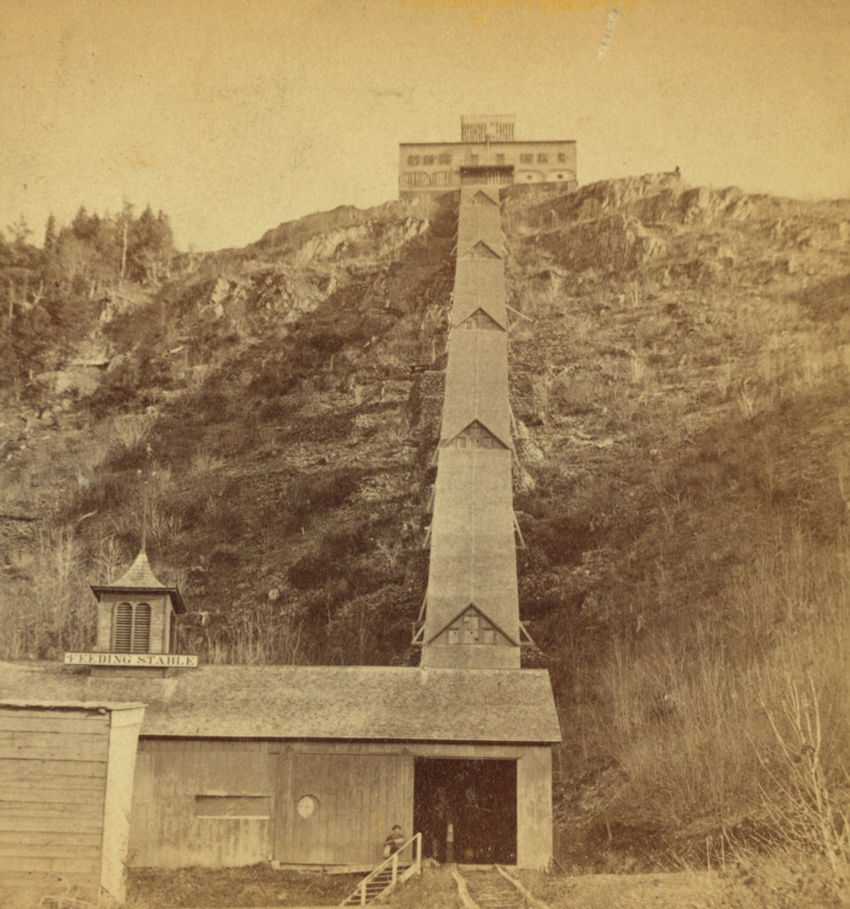
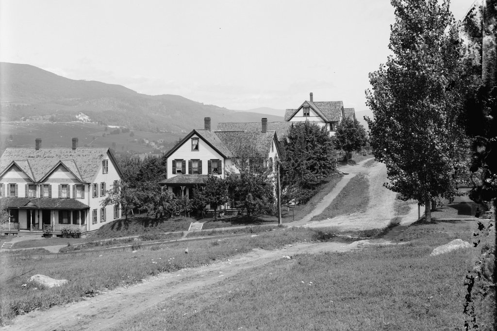
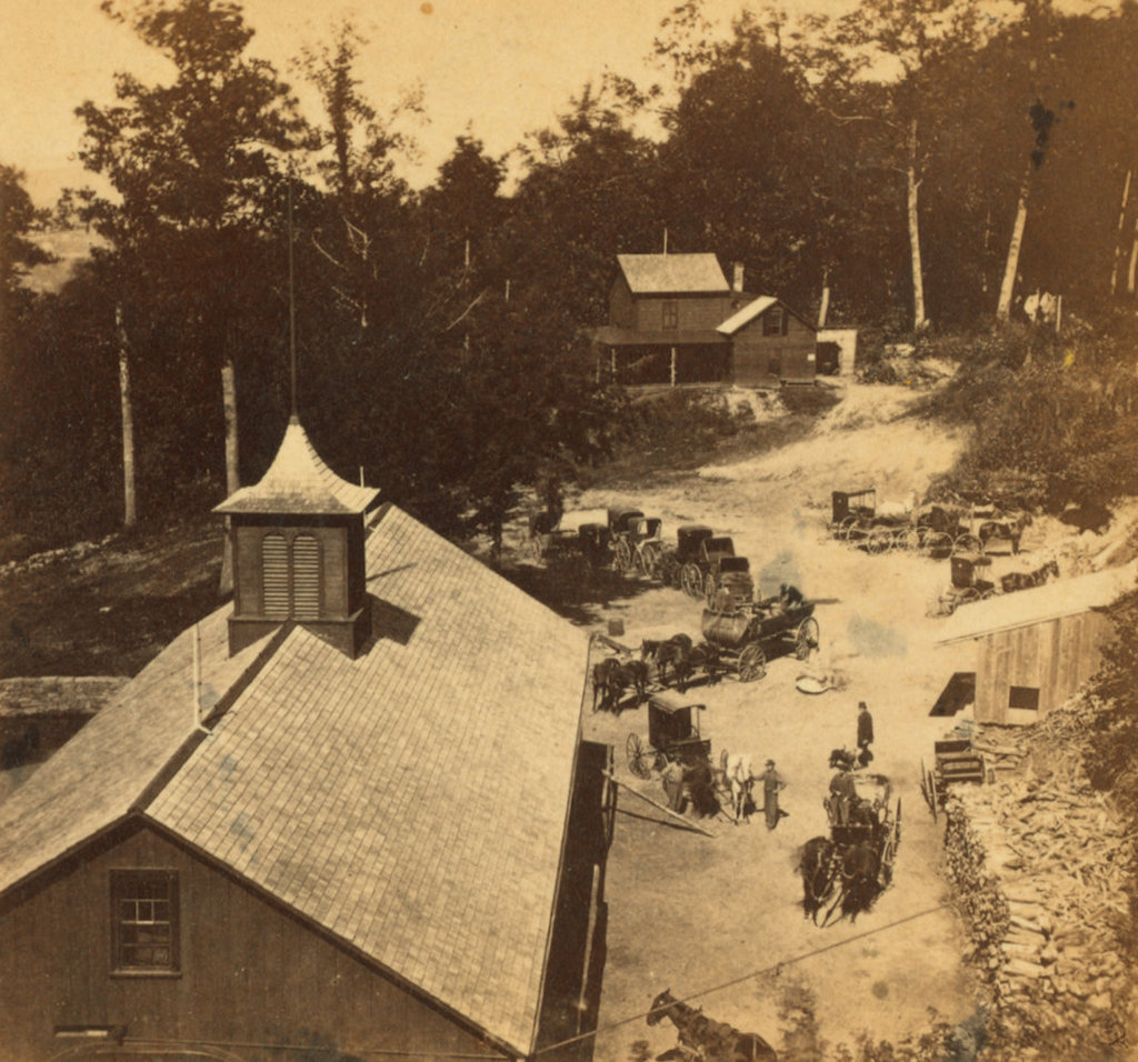
The inclined railway leading up to the Summit House on Mount Holyoke, around 1867 to 1885. Image courtesy of the New York Public Library.
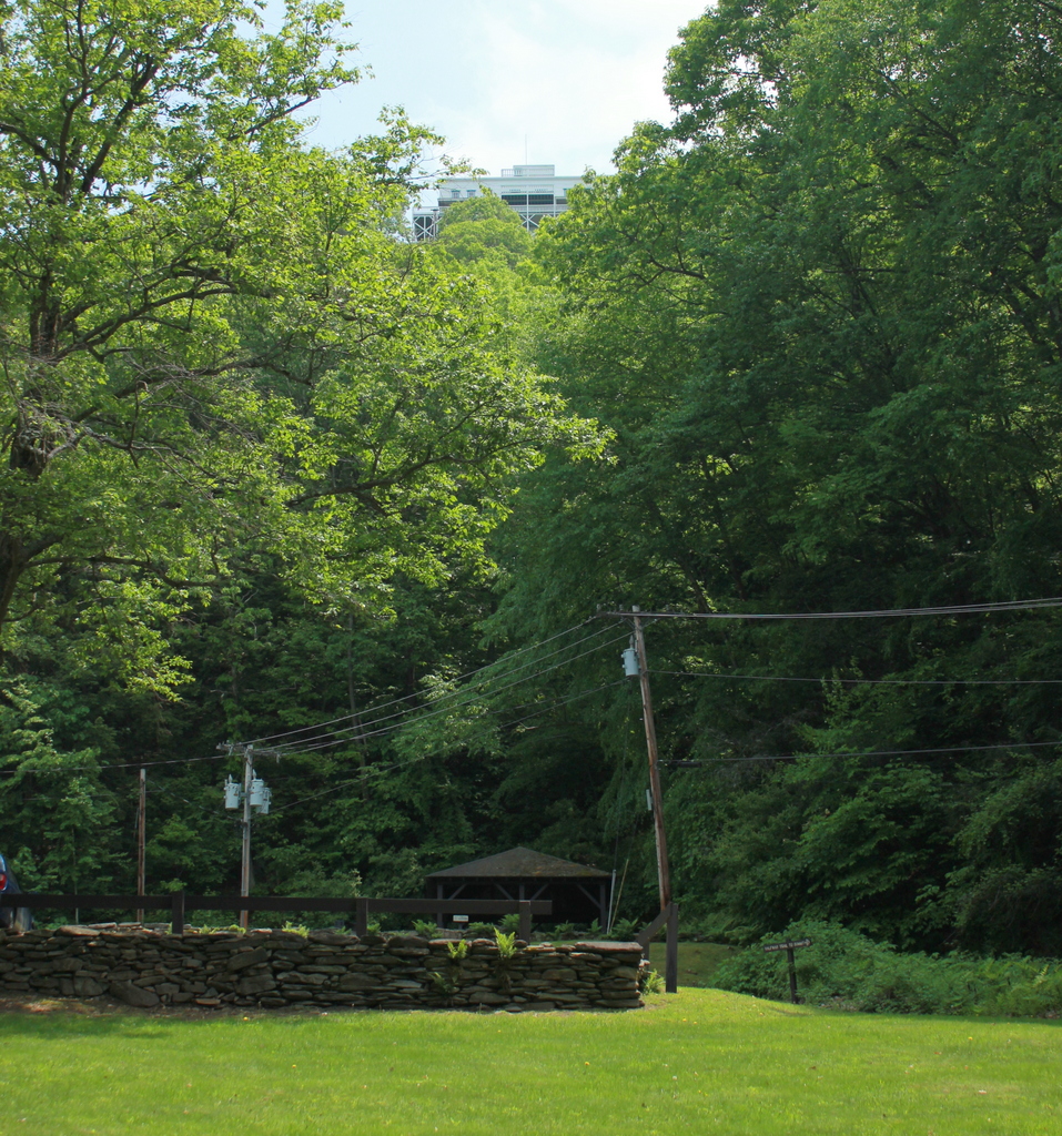
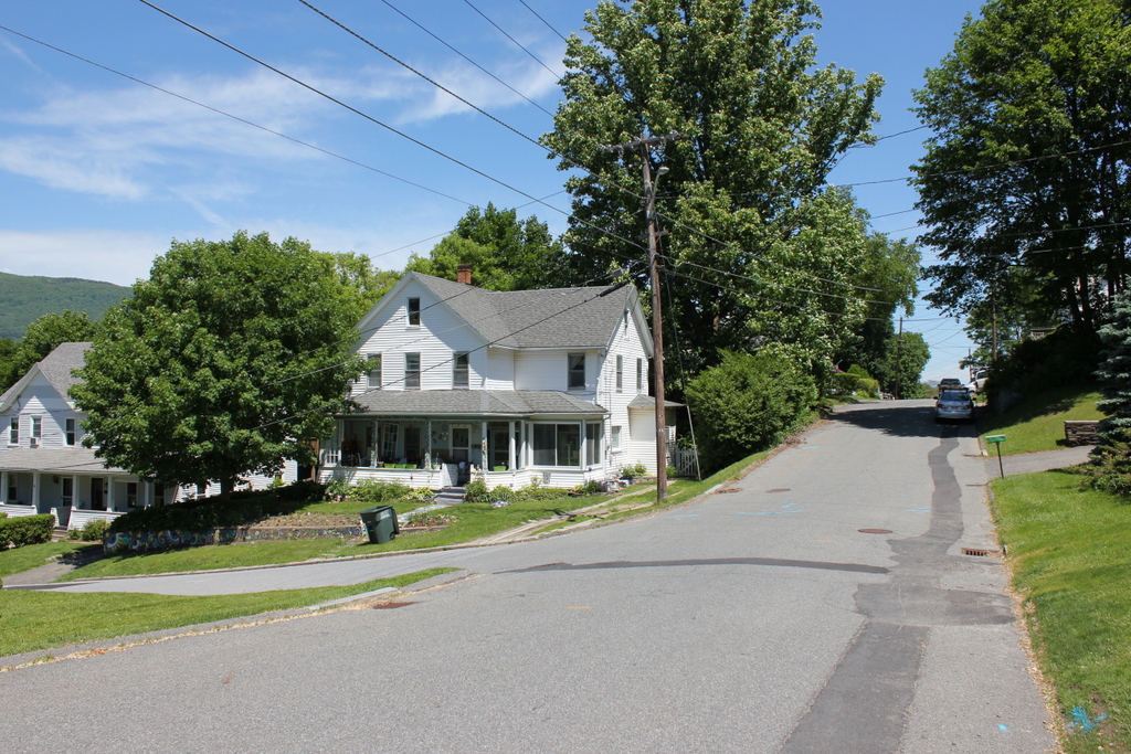
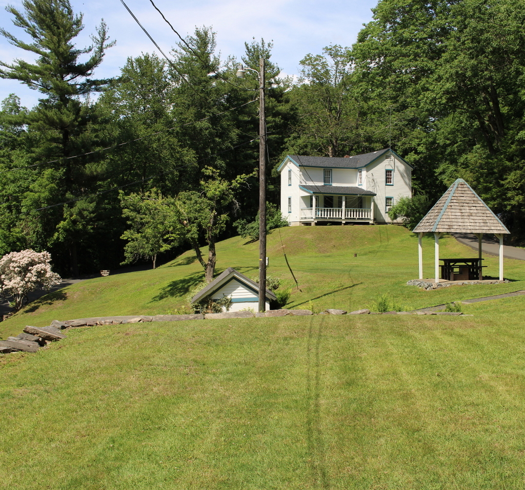
The scene in 2019:

As discussed in the previous post, the summit of Mount Holyoke was the site of one of the first mountaintop hotels in the United States. At just 935 feet in elevation, it is not a particularly tall mountain, yet it rises high above the surrounding landscape in the otherwise low, flat Connecticut River valley. It is part of the Holyoke Range, a narrow ridgeline that runs east to west for about eight miles. This, in turn, is a sub-range within the much longer Metacomet Ridge, a traprock ridge that extends from Long Island Sound in Connecticut to just south of the Massachusetts-Vermont border.

Mount Holyoke is not the highest peak in the Holyoke Range, as it stands nearly 200 feet lower than Mount Norwottuck. However, it forms the western end of the ridge, with the Connecticut River passing through a narrow gap between Mount Holyoke and the Mount Tom Range. This prominent location makes it a major landmark for travelers in the river valley, and it also means that the summit has nearly 360-degree views of the surrounding landscape.

The combination of dramatic views and proximity to large large population centers made Mount Holyoke a popular destination in the 19th century, and the first building at the summit was built in 1821. In the spirit of a traditional barn raising, it was built with the help of nearly 200 townspeople who climbed to the summit to lend a hand. Consuming, as one 19th century account described it, “a little water with a good deal of brandy in it,” the group completed the summit house in just two days. It was a modest structure, measuring just 18 by 24 feet, but it was dedicated with much fanfare, including a speech by Northampton native and U. S. Senator Elijah H. Mills.

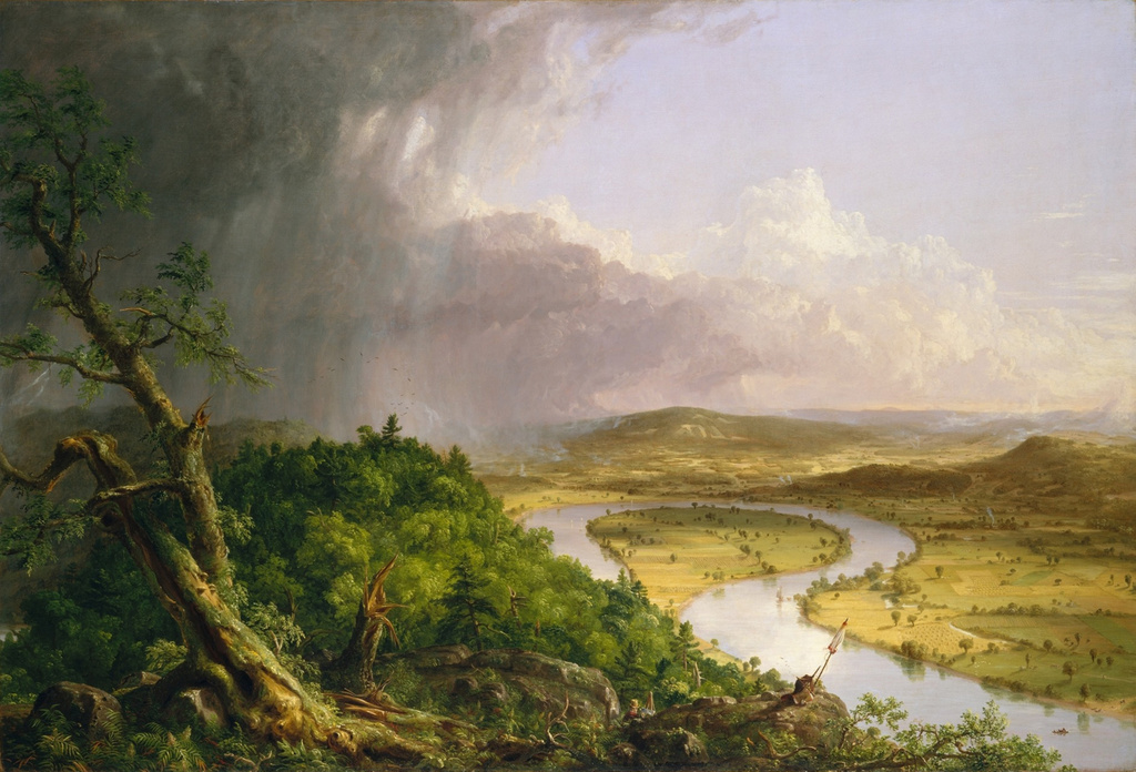
This first building was soon joined by a rival establishment nearby, but the two buildings were consolidated under the same ownership in 1825. The business operated here for several more decades, and during this time the view from the top of the mountain was made famous by Thomas Cole’s 1836 painting The Oxbow, long regarded as a masterpiece of 19th century American landscapes.

However, despite the mountain’s growing popularity, the accommodations at the summit remained primitive until mid-century. This began to change in 1849, when Northampton bookbinder John French and his wife Frances purchased the property. They soon began making improvements, most significantly a new hotel at the summit, which was completed in 1851. It was named the Prospect House, and it had two stories, with a dining room, sitting room, and office on the first floor, and six guest rooms on the second floor. Above the second floor was a cupola, which was equipped with a telescope. The hotel was later expanded several times, but this original 1851 structure still survives as part of the present-day building.

In addition to constructing a more substantial building, French also improved access to the summit. Prior to his ownership, it was relatively easy to reach the spot where these two photos were taken, whether on foot or by carriage. In terms of elevation, this spot is more than halfway up the mountain, but from here the slope becomes significantly steeper, as is made particularly evident in the first photo. The only options for visitors during the first half of the 19th century were either to take the long, winding, narrow carriage road to the summit, or hike the short but steep path up the mountainside, gaining over 350 feet in elevation in just 600 horizontal feet.

Neither option was ideal for most visitors, and the situation also made it difficult for French to bring supplies up the mountain. Even water had to be either carted or carried up to the summit, requiring him to sell it for around three to five cents per glass, or about $1.00 to $1.50 today. However, in 1854 he solved both problems with the construction of an inclined railway. It began here at this spot, next to French’s residence, which was known as the Halfway House, and it rose to the top of the mountain. It was originally powered by a stationary horse here at the base, although in 1856 French switched to steam power. The railway itself was rebuilt several times, but it had largely assumed its final form by 1867, as shown in the first photo. By then, the railway had two tracks, was completely enclosed, and brought its passengers directly into the basement of the hotel.

In the meantime, the hotel also grew, with the first major addition coming in 1861, when it was expanded to ten rooms. Then, in 1871 French sold the property to South Hadley businessman John Dwight. However, John and Frances French remained here to manage the hotel, and they continued in that role until their deaths in the 1890s. Then, the hotel was expanded even further in 1894, with the addition of a large wing on the south side of the building. This increased the hotel’s capacity to 40 guests, along with a dining room that could seat 200 people.

By then, the hotel had several local competitors on the nearby Mount Tom Range, with the Eyrie House atop Mount Nonotuck, and the Summit House on Mount Tom. However, both of these were plagued by fires, which was a constant danger for wood-frame buildings on isolated mountaintops. The Eyrie House, built in 1861 and later expanded, burned in 1901, and the same fire also destroyed the partially-built structure of what would have been a new hotel. The Summit House on Mount Tom faced similar problems, with the original 1897 one burning in 1900, and its replacement suffering the same fate in 1929.

However, although older than the other nearby summit houses and built of similar materials, the hotel here on Mount Holyoke managed to avoid catastrophic fires. It faced different challenges, though, most significantly the declining popularity of mountaintop hotels in general. John Dwight died in 1903, the property was subsequently acquired by a group of prominent locals, including Holyoke silk manufacturer Joseph Skinner. The new owners made significant improvements, including electricity and modern plumbing. The railway was also electrified, and the first automobile road to the summit opened in 1908.

Skinner would ultimately acquire full ownership of the hotel, and he continued to modernize it throughout the early 20th century. It continued to face challenges though, particularly with the onset of the Great Depression, but the hotel was ultimately closed after the September 1938 hurricane. The older section of the building survived, but the storm destroyed the large 1894 addition. A year later Skinner donated the property to the state, and it became the Joseph Allen Skinner State Park.

Both the hotel and the inclined railway deteriorated after the park was established, and much of the roof over the railway was destroyed in a heavy snowstorm in 1948. The remains of the railway were removed in 1965, and the hotel itself was also threatened with demolition around this time. Despite many years of neglect, though, the building was ultimately restored in the 1980s, and it is now a museum.

Today, nearly all of the historic 19th century mountaintop hotels in the northeast are gone, most having been lost to fire, neglect, or both. However, the Summit House on Mount Holyoke is still standing as one of the few surviving examples. This scene has changed considerably since the first photo was taken around 150 years ago, including the loss of the railway and the significant tree growth on the previously bare slopes, but the Summit House is still visible from this spot.

Mount Holyoke Halfway House, Hadley, Mass

The Halfway House on the northern slope of Mount Holyoke in Hadley, around 1867-1885. Image courtesy of the New York Public Library.

The scene in 2021:


For the past two centuries, the view from the top of Mount Holyoke has been one of the most celebrated mountaintop scenes in New England. Although only 935 feet above sea level, the traprock mountain rises abruptly from the low valley floor, providing nearly 360-degree views of the Connecticut River and the surrounding countryside. As a result, the mountain has drawn countless visitors over the years, and its view has been the subject of many works of art, including one of the most iconic American landscape paintings, Thomas Cole’s The Oxbow.

During the Romantic era of the early 19th century, a new emphasis on nature helped to spur interest in landscapes and scenery. Mountains, which had previously been regarded as impediments to travel, became destinations in their own right, leading to a proliferation of mountaintop hotels, particularly here in the northeast. Among the first of these was a small cabin that was built at the summit of Mount Holyoke in 1821. A second, rival structure was built a few years later, but it would be another three decades before a real hotel was built at the summit.

In 1849, Northampton bookbinder John French and his wife Frances purchased the property at the summit, and soon began construction on a new, more substantial structure. Completed in 1851 and named the Prospect House, the hotel was two stories in height, with a dining room, sitting room, and office on the first floor, and six guest rooms on the second floor.

French originally intended to live in the hotel year-round, but the windswept summit proved too cold and isolated in the winter, so in 1852 he and his family moved into a house on the northern slope of the mountain, shown here in the upper right side of both photos. It was known as the Halfway House, and in terms of elevation it is just over halfway from the valley floor to the summit. However, beyond here the climb becomes significantly more difficult. Up to this point, it is a steady but moderate ascent, but after the Halfway House the most direct route to the summit is up a steep slope, gaining over 350 feet in elevation in just 600 feet.

When the Prospect House opened, the only way up to the hotel from the Halway House was either by riding along a winding, narrow carriage road, or by climbing the short but steep path to the summit. Not only was this challenging for visitors to reach the hotel, but it also made it difficult for French to bring supplies. With no springs anywhere near the summit, water was a particularly scarce commodity, as it all had to be carted or carried up these same routes. As a result, visitors were charged for the water that they drank, paying between three and five cents per glass, or about $1 to $1.50 today. In addition, other liquid refreshments sold for considerably higher on the mountain than elsewhere.

In order to solve these problems, in 1854 French built an incline railway from here at the Halfway House to the summit. It was originally powered by a stationary horse, but two years later French replaced it with a steam engine. The entire railway was 600 feet in length, and by the late 1860s it was completely enclosed by a wooden shed. These two photos were taken from around the spot where the railway began, and from here it brought visitors directly into the basement of the Prospect House, allowing them to reach the hotel without even stepping outside.

John French expanded the hotel in 1861, and in 1867 he added a second track to the railway. Throughout this time, he and Frances resided at the Halfway House. The 1870 census shows them here with their 21-year-old daughter Frances. At the time, they also had three employees who lived here with them, including a clerk, a domestic servant, and a teenager who was listed as a “boy of all work.” The census listed the value of French’s real estate at $20,000, plus a personal estate valued at $8,000, for a total net worth equivalent to around $575,000 today.

French ultimately sold the hotel a year later in 1871 to South Hadley businessman John Dwight. However, Dwight retained John and Frances to manage the hotel, and they continued to live here in this house. The 1880 census lists them here along with a number of employees, including a telegraph operator, two cooks, a waiter, and an engineer. However, it seems unlikely that they would have all lived together in this small house, so they may have lived in other nearby buildings, or perhaps even in the hotel itself.

John French lived here until his death in 1891, and Frances until she died in 1899. By then, the hotel had been expanded even further. with an 1894 addition that gave the building a capacity of 40 guests. However, despite this growth the hotel entered a decline in the early 20th century. It was eventually acquired by wealthy Holyoke silk manufacturer Joseph Skinner in 1915, and he set about modernizing the building. Despite these improvements, though, the the heyday of mountaintop hotels had passed, and the Great Depression further compounded the problem. Then, the 1938 hurricane caused substantial damage to the hotel, requiring the demolition of the 1894 addition.

Skinner ultimately donated the hotel and its property to the state in 1939, with the land becoming the Joseph Allen Skinner State Park. However, the state showed little interest in the buildings on the property, which were largely neglected for many years. The inclined railway was last used in the early 1940s, and it was badly damaged after the roof of the shed collapsed in a heavy snowstorm in 1948. The remains of the railway were ultimately removed in 1965, and the hotel itself was also nearly demolished in the second half of the 20th century. However, it was instead restored, and it now serves as a museum.

Today, despite the loss of the railway, the Halfway House itself is still standing. It has been enlarged since the first photo was taken, with the addition of a second story above the rear part of the building, but otherwise it is still recognizable from its 19th century appearance. Although there are no longer any overnight accommodations at the summit, Mount Holyoke remains a popular destination. Most visitors still pass by the Halfway House on their way up the mountain, either by way of the auto road on the left side of the scene, or the hiking trail that crosses the road here before ascending steep slope to the summit.