Springfield & Connecticut River from Forest Park (2)

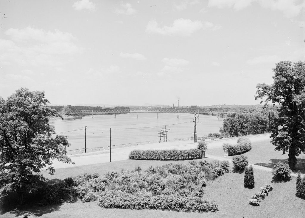
Looking north up the Connecticut River toward downtown Springfield, from Laurel Hill in Forest Park, around 1905. Image courtesy of the Library of Congress, Detroit Publishing Company Collection.
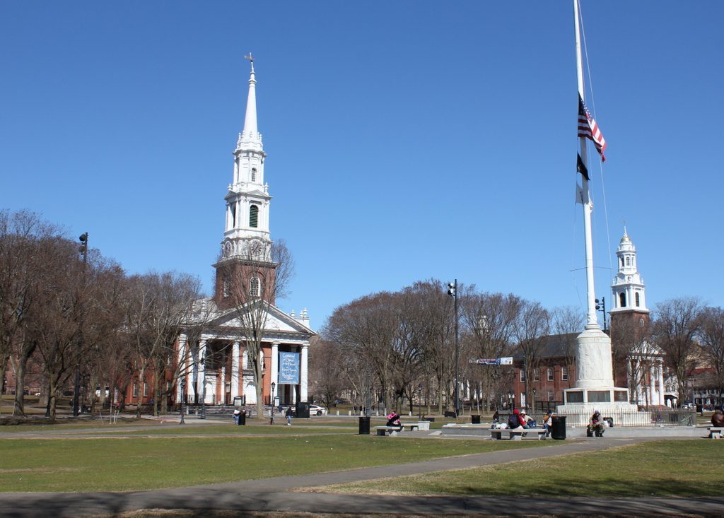
The scene in 2018:

These photos were taken from the same spot as the ones in a previous post, but they show the view looking a little further to the left, directly up the Connecticut River. The location of these photos is Laurel Hill, a bluff on the western end of Forest Park. It was once part of the estate of Everett H. Barney, a wealthy ice skate manufacturer who built his mansion, Pecousic Villa, nearby in 1883. He had intended to build a second home here on Laurel Hill for his only child, George, but George died in 1889 at the age of 26, and Everett instead build a mausoleum here on the hill.

A year later, Everett donated his property – which included the house, a carriage house, and meticulously-landscaped grounds – to the city. This land became part of Forest Park, which had been established 1884 after another benefactor, Orrick H. Greenleaf, gave what is now the eastern section of the park. Barney’s gift extended the park all the way west to the Connecticut River, and his only stipulation was that he and his wife be allowed to live at Pecousic Villa for the rest of their lives.

Perhaps the most scenic part of the newly-expanded park was here at Laurel Hill, where an overlook near the mausoleum provided sweeping views of the Connecticut River and downtown Springfield. In the foreground of the photo is the western entrance to the park, flanked by hedges and a pair of stone markers with the letter “B” carved into them. Longhill Street runs across the foreground, along with trolley tracks that are barely visible in the road. More noticeable from this angle are the poles that supported the overhead wires for the trolleys. The railroad also passed through this scene, although the tracks are hidden from view because they ran further down the embankment between the street and the river.

In the center of the first photo is the South End Bridge, an iron truss bridge that was completed in 1879. It was the third bridge across the river in Springfield, after the Old Toll Bridge in 1805/1820 and the North End Bridge in 1877, and it provided direct access to the city from Agawam and points to the south and west, replacing an earlier ferry that had operated here. Just beyond and to the left of the bridge is the mouth of the Westfield River, which is one of the largest tributaries of the Connecticut River.

Further upstream from the bridge is downtown Springfield, which is marked by an assortment of church steeples and smokestacks. The white, wooden steeple of Old First Church is visible in almost the exact center of the photo, and just to the right of it is the granite tower of the Hampden County Courthouse. Other identifiable steeples include, from left to right, those of St. Joseph’s Church, St. Michael’s Cathedral, Church of the Unity, and South Congregational Church. Aside from these churches, another major landmark is the main arsenal of the Springfield Armory, which is visible to the right, on a bluff overlooking the city.

In the nearly 115 years since the first photo was taken, this scene has undergone some dramatic changes. The most obvious of these is the construction of Interstate 91, which now passes through the narrow space between Laurel Hill and the Connecticut River. This section of the highway was built in the early 1960s, and the project required the demolition of Pecousic Villa, which had been  acquired by the city after Everett Barney’s death in 1916. However, the carriage house was spared, and it still stands on the bluff, just out of view on the far right side of the scene. Both the mausoleum and the overlook on Laurel Hill are also still part of Forest Park, although the modern-day view lacks the same picturesque attributes of the first photo.

Aside from Interstate 91, another major change to this scene is the South End Bridge. Also known as the Julia B. Buxton Bridge, the present-day South End Bridge was completed in 1954, replacing the old 1879 bridge from the first photo. Further in the distance, the Springfield skyline is also very different from the early 20th century. For many years, the city had no skyscrapers because of height restrictions, but these were lifted in 1970 with the construction of the 371-foot Tower Square, which is visible in the center of the 2018 photo. Several other skyscrapers would be built in the ensuing years, including the Monarch Place office building to the right of Tower Square, and the Chestnut Park apartment building a little further to the right.

Despite all of these changes, though, there are some surviving landmarks from the first photo. The churches are no longer the dominant features in the skyline, yet some of them are still standing, including Old First Church, St. Michael’s Cathedral, and South Congregational. The old courthouse is also still there, as is the Armory, but these older buildings are now joined in this scene by modern hotels, office buildings, parking garages, and the silver dome of the Basketball Hall of Fame.

New Haven Green, New Haven, Connecticut (3)

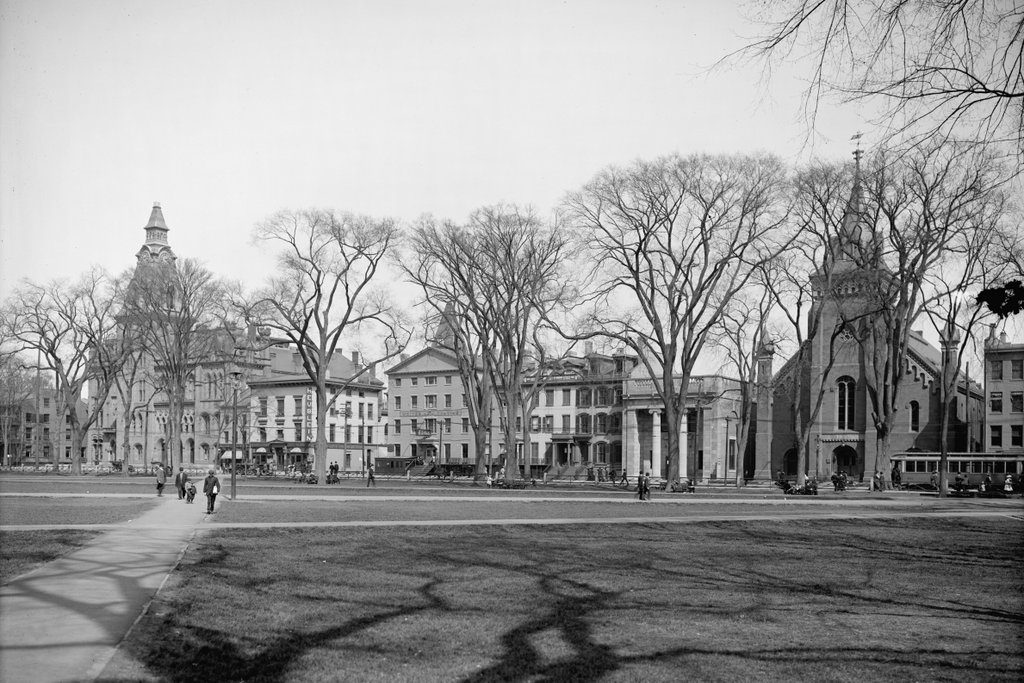
Looking east on the New Haven Green, from near the corner of Temple and Chapel Streets in New Haven, around 1900-1910. Image courtesy of the Library of Congress, Detroit Publishing Company Collection.

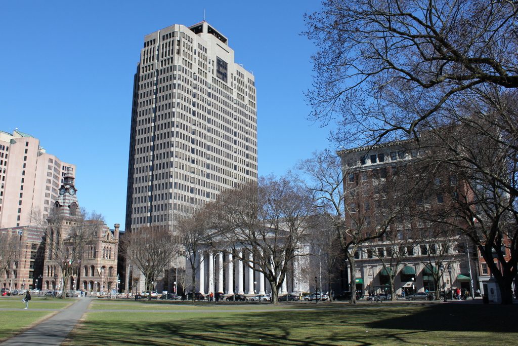
The scene in 2018:

The first photo was taken from about the same spot – and presumably on the same day – as the one in the previous post, although this one shows the view looking toward Church Street on the eastern edge of the New Haven Green. Like the scene in the previous post, this view underwent dramatic changes within about a decade after the first photo was taken. The city saw rapid growth at the turn of the 20th century, with the population more than doubling between 1880 and 1910, and this helped to spur several major redevelopment projects that replaced older buildings here along the Green.

Beginning on the left side of the first photo is City Hall, an ornate High Victorian Gothic-style building that was completed in 1861. To the right of it, at the corner of Court Street, was a three-story building that housed Heublein’s Cafe. This restaurant was owned by Gilbert Heublein, a prominent food and beverage distributor who later built the Heublein Tower in Simsbury. Further to the right, in the center of the photo, was the Tontine Hotel, which was built in the 1820s, and on the far right side was the former Third Congregational Church. Built in 1856, it served as a church until 1884, when its congregation merged with the United Church. In 1890, it became the home of the New Haven Free Public Library, and it was used until the current library building opened in 1911.

The most significant change to this scene came soon after the first photo was taken. In the early 1910s, both the Tontine Hotel and the former Third Congregational Church were demolished to make way for two new buildings. On the left side, the Tontine Hotel was replaced with a new post office and federal courthouse, which was constructed between 1913 and 1919. Just to the right of it, the site of the church became the Second National Bank of New Haven, with an eight-story building that was completed in 1913. Today, both of these are still standing, but the only surviving buildings from the first photo are City Hall on the far left, and the Exchange Building, which is partially visible on the extreme right side of both photos.

New Haven Green, New Haven, Connecticut (2)

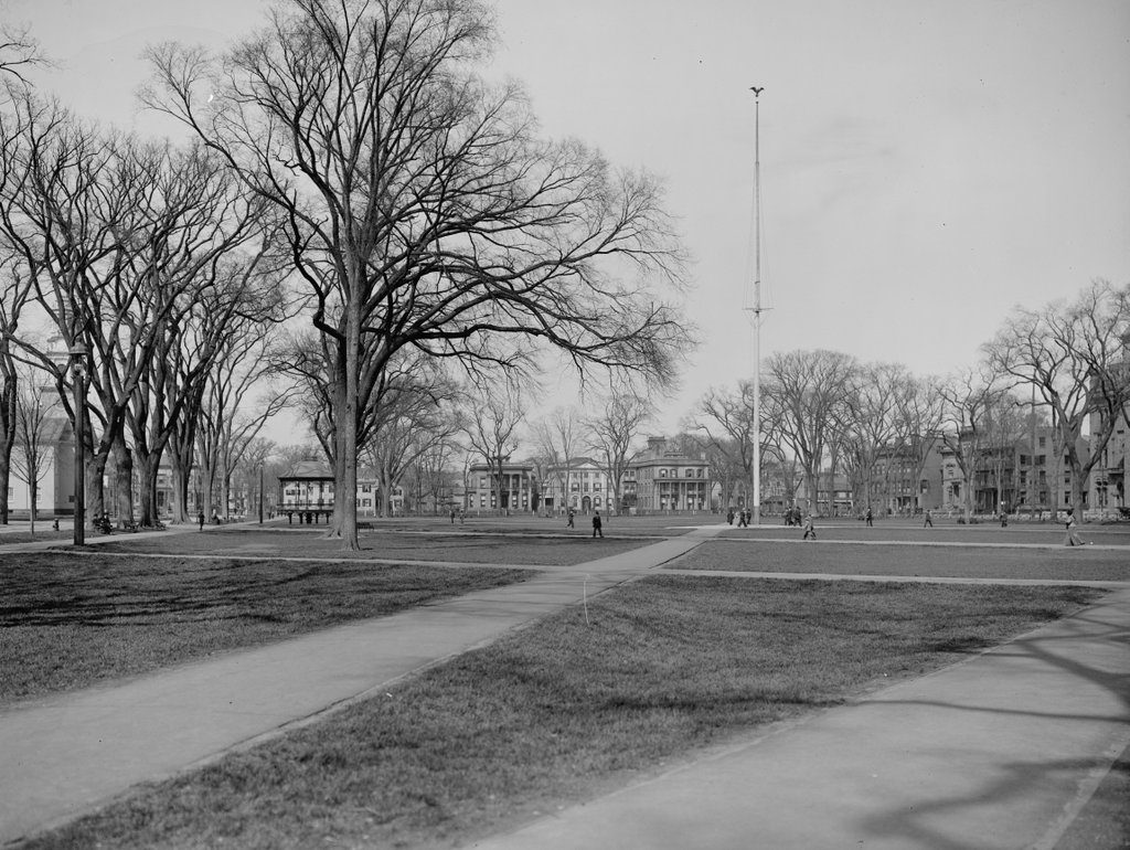
Looking northeast on the New Haven Green, from near the corner of Temple and Chapel Streets in New Haven, around 1900-1910. Image courtesy of the Library of Congress, Detroit Publishing Company Collection.

The scene in 2018:

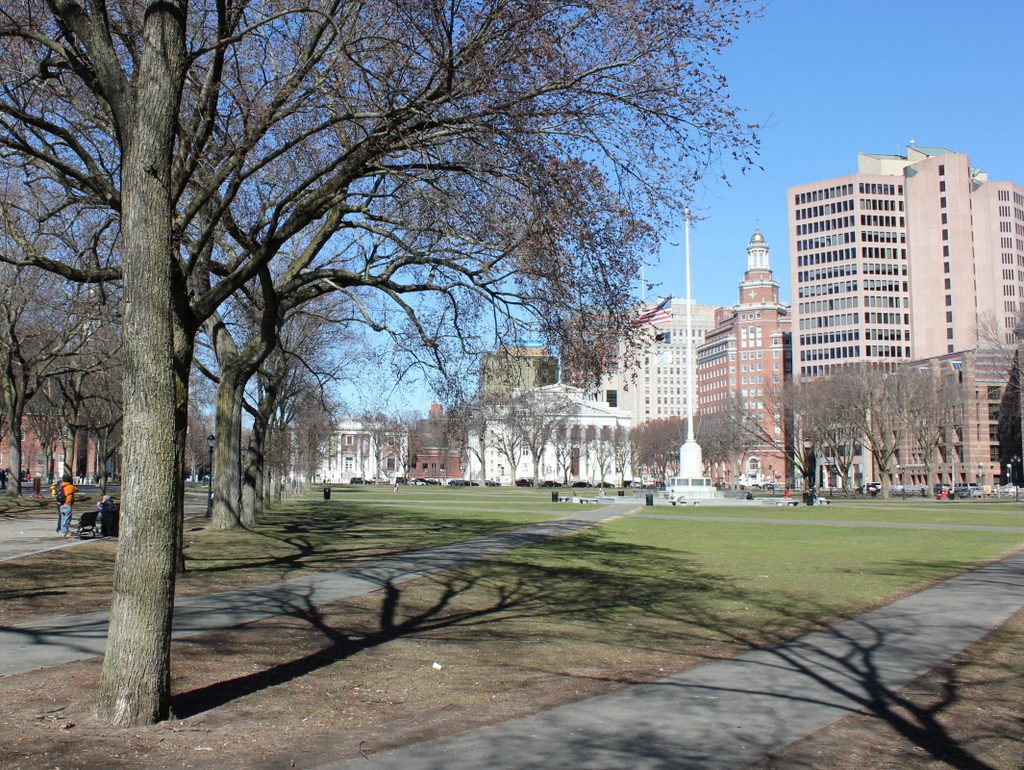
The New Haven Green has served as the political, commercial, social, and cultural center of New Haven since 1638, when it was established as one of the first town commons in the English colonies. Just out of view to the left are three historic churches that stand on the Green, and behind them was the site of New Haven’s old state house and, further to the left, the Old Campus of Yale University. On the far right, also just out of view, is City Hall, which is located on the east side of the Green. The south side of the Green, located directly behind the photographer, was the site of several major department stores in the late 19th and early 20th centuries.

This particular scene faces the north side of the Green, which is bounded by Elm Street. This section of Elm Street was once known as Quality Row, because of the many elegant mansions that lined the street opposite the Green. Three of these are visible in the first photo, in the center of the scene just to the left of the flagpole. Probably the most significant of these was the light-colored home in the center. This elegant Federal-style mansion was built in the late 1810s, and was the work of noted architect David Hoadley. The original owner was Nathan Smith, a lawyer and politician who later went on to serve in the U. S. Senate.

All three of these houses were demolished within about a decade after the first photo was taken. As New Haven grew, the previously residential area on the north side of the Green was eyed as the site of several different public buildings. The first of these was the main branch of the New Haven Public Library, which was built between 1908 and 1911 on the left side of the scene, at the corner of Elm and Temple Streets. This was followed in 1914 by the New Haven County Courthouse, which stands on the right side of the block at the corner of Elm and Church Streets. Today, these two buildings are now more than a century old, and they still stand on the north side of the Green as two important architectural and historic landmarks in downtown New Haven.

Temple Street, New Haven, Connecticut

The view looking north on Temple Street from near the corner of Chapel Street in New Haven, around 1900-1910. Image courtesy of the Library of Congress, Detroit Publishing Company Collection.

The scene in 2018:

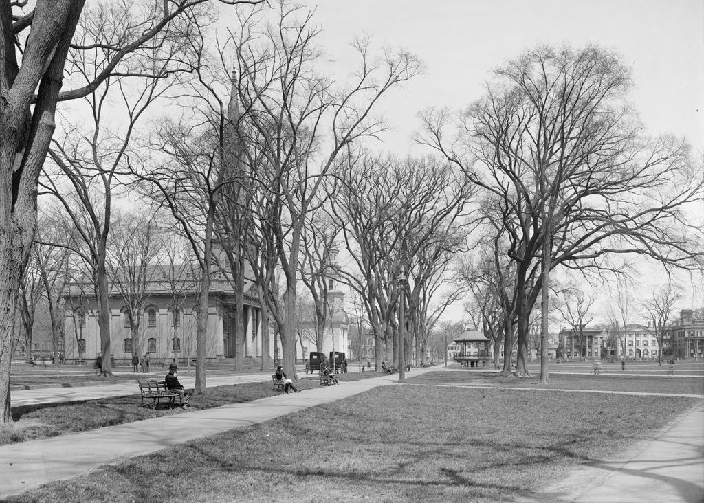
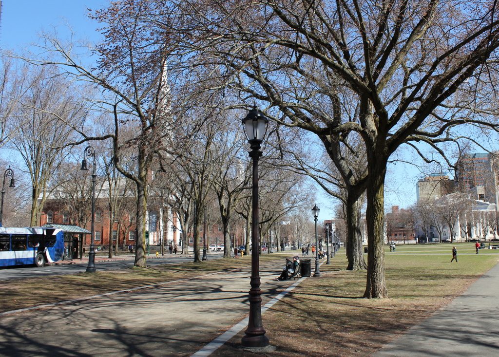
This block of Temple Street passes through the New Haven Green, and in front of three historic churches that stand on the Green. The southernmost of these, the 1816 Trinity Church, is just out of view on the far left side of the scene, but the 1814 Center Church, along with the more distant 1815 United Church, are both visible on the left side of the street. The latter two churches have very similar designs, with each one featuring a brick exterior and Federal-style architecture. Both of these photos also show the eastern portion of the Green, with a number of people walking across it or sitting on benches. The longer exposure time of the first photo is shown by the blurred images of several people walking on the right side, while the people seated on the left remain sharp and clear.

Today, more than a century after the first photo was taken, much of this scene has remained largely unchanged, particularly in the foreground and on the left. All three churches are still standing and in active use by their congregations, and they are contributing properties in the New Haven Green Historic District, which is a National Historic Landmark. However, there have been some significant changes to this scene, particularly in the distance on the right side. This block of Elm Street was once known as Quality Row, and had a number of elegant early 19th century mansions that are visible in the first photo. These included the Nathan Smith House, which stood second from the right. It was built around 1815, and was once the home of U. S. Senator Nathan Smith, but it was demolished – along with the rest of Quality Row- by the 1910s, soon after the first photo was taken. The block is now occupied by the 1911 New Haven Free Public Library on the left, and the 1914 New Haven County Courthouse on the right.

Center Church and United Church, New Haven, Connecticut

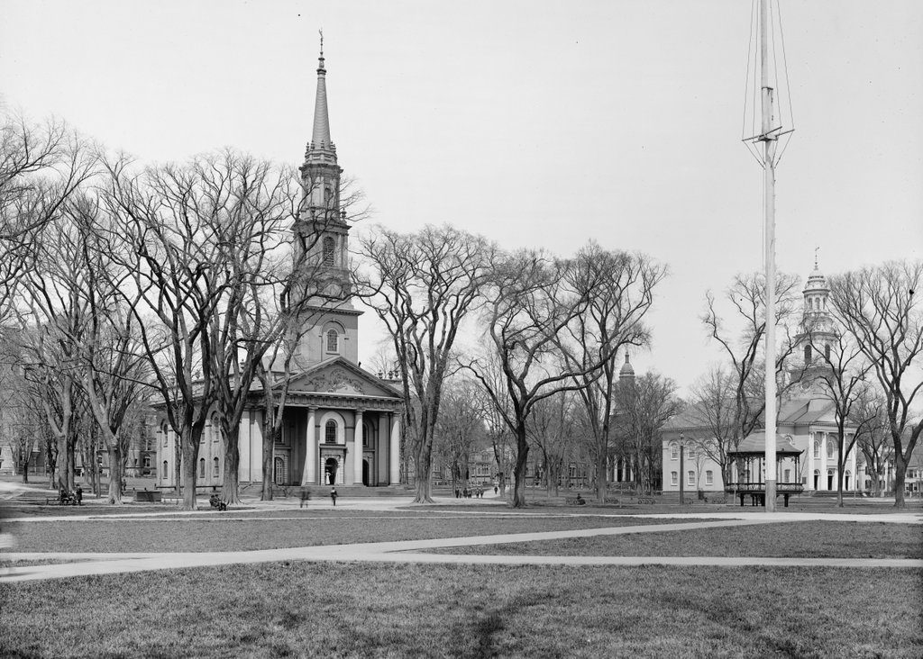
Center Church and United Church, as seen looking west on the New Haven Green, around 1900-1915. Image courtesy of the Library of Congress, Detroit Publishing Company Collection.

The scene in 2018:

This view shows two of the three historic churches that were built on the New Haven Green in the 1810s. The oldest of these, on the left side of the scene, is Center Church, which was completed in 1814. It was built of brick, and featured a Federal-style that was designed by Asher Benjamin and Ithiel Town, two Connecticut-born architects who were among the leading American architects of the early 19th century. Like many New England churches of this period, it featured a columned portico, along with a tall, multi-stage steeple that rose above it.

Although not readily apparent in this view, one of the more unusual features of Center Church is its basement. Throughout the colonial era, this section of the Green served as New Haven’s burial ground, and an estimated 4,000 to 5,000 bodies were interred here. Center Church was built in the midst of this cemetery, but rather than removing the remains or the headstones, the church was simply built above them. The ground became the floor of the basement, but otherwise the graves were not disturbed, and the headstones are still well-preserved today. However, this was only a small portion of the entire cemetery. The rest of the headstones, which are once located around the outside of the church, were moved to Grove Street Cemetery in 1821. The remains themselves were not disinterred, though, and they are still buried here under the Green.

In the meantime, Center Church was joined by two other churches in the mid-1810s. To the right of it, at the corner of Temple and Elm Streets, is the United Church, which was completed in 1815. It was, along with the neighboring Center Church, a Congregationalist church, and it likewise had very similar architecture. There is some disagreement among historic sources over who the architect was, but it appears to have been Ebenezer Johnson, Jr. His design was likely influenced by Center Church, but the United Church does have some differences, such as a lack of a portico, and it featured a shorter steeple with a rounded top, instead of a tall pointed spire.

The third church to be built here on the Green was Trinity Church, completes a year after United Church in 1816. Although not visible in these photos, it featured Gothic-style architecture that sharply contrasted with its Federal-style neighbors, and was one of the first Gothic churches to be built in the country. Today, all three of these church buildings are still here, and they are all contributing properties in the New Haven Green Historic District, which was designated as a National Historic Landmark in 1970. Overall, very little has changed in this scene, and even many of the buildings in the distance have remained. These include another historic church, the First and Summerfield United Methodist Church, which can be seen in the background just beyond and to the left of the United Church. It was built in 1849, with a design similar to these other two churches, and it still stands at the corner of Elm and College Streets.

Old Campus, New Haven, Connecticut

The Old Campus of Yale University, seen looking west from the New Haven Green, around 1900-1915. Image courtesy of the Library of Congress, Detroit Publishing Company Collection.

The scene in 2018:

This scene has hardly changed in more than a century since the first photo was taken, yet it would have looked very different just a couple decades earlier, when the Old Brick Row still stood here. Constructed between 1752 and 1824, this group of seven building comprised the bulk of the Yale campus until the late 19th century, when they were steadily replaced by more modern Gothic-style buildings, as seen in the first photo. This transition also marked a dramatic shift in the layout of the campus. Unlike the Old Brick Row, which had been built in a single line that was set back from the street, these new buildings were constructed right up against the street, along the entire perimeter of the block, with a large quadrangle in the center.

These two photos show the east side of the Old Campus, which consists of a group of five buildings along College Street. The oldest of these is Farnam Hall, which stands second from the right. It is somewhat difficult to distinguish from the other buildings, but it is identifiable by its somewhat lower roof line. It was completed in 1870, and was the first of the dormitories to be built under the new campus plan. Immediately to the right of it, on the far right side of the scene, is the Battell Chapel, which was completed in 1876, and to the left of Farnam Hall is Lawrance Hall, a dormitory that was completed in 1886. All three of these buildings, along with nearby Durfee Hall, were designed by noted architect Russell Sturgis, and they all feature the High Victorian Gothic style of architecture that was popular during this period.

The two buildings on the left side of the scene were built a few years later. They were architecturally similar, although their style could perhaps best be described as English Gothic. As explained in a previous post, these were also designed by prominent architects. To the left is Welch Hall, a dormitory that was completed in 1891 and was designed by Bruce Price. The final link in this row of buildings, Phelps Hall, was built five years later. It was designed by Charles C. Haight, who gave it the appearance of a medieval gatehouse. On the ground floor is the Phelps Gate, which serves as the main entrance to the Old Campus from the east, and the upper floors were built with recitation rooms.

Several more buildings would be added to the Old Campus after the first photo was taken, but otherwise the quadrangle was largely complete by the time Phelps Hall was constructed. This particular view has hardly changed at all. The buildings have seen only minor exterior alterations, and the only new building visible in the present-day scene is the Harkness Tower, which was completed a block away from here in 1922, and can be seen in the distance just to the left of Phelps Hall. Another building of interest, which appears in both photos, is Connecticut Hall. Visible in the distance on the far left side of the scene, it is the only surviving building from the Old Brick Row. It was built in 1752, and although threatened with demolition at the turn of the century, it was ultimately restored, and it now stands as the oldest building on the Yale campus.