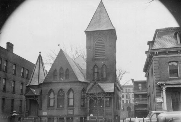
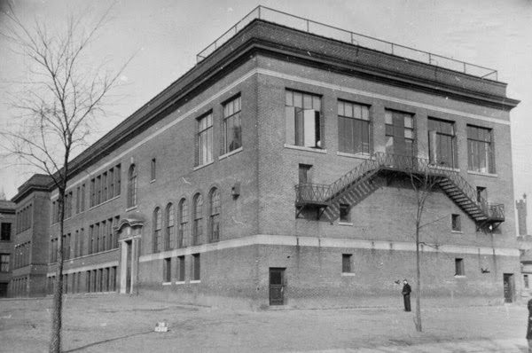
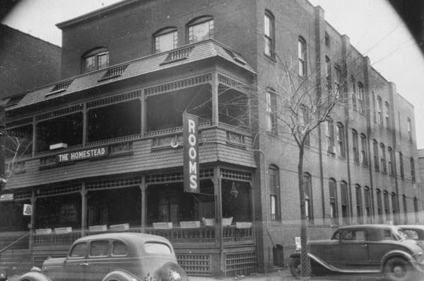
Bliss Street Parking Garage, Springfield Mass

The garage at 16 Bliss Street in Springfield, around 1938-1939. Courtesy of the Springfield Preservation Trust.

tnc02_1938-1939 spt

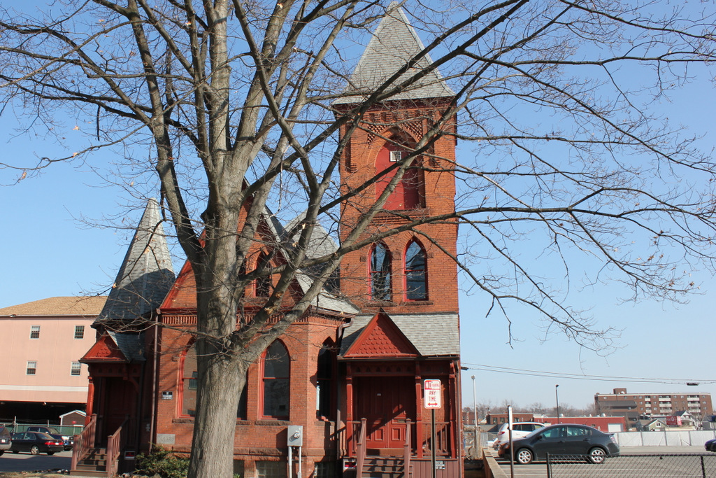
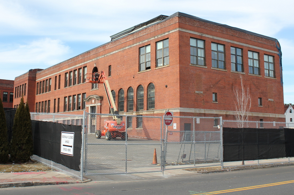
The building in 2015:
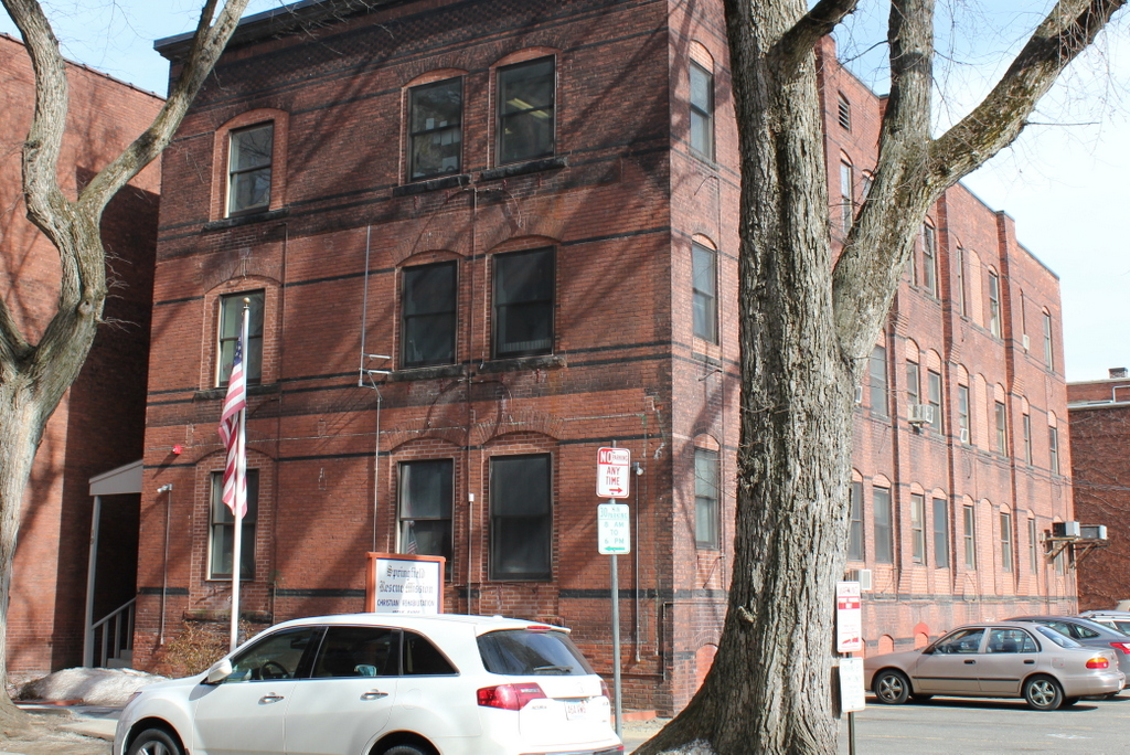
451_2015

Some then & now scenes are remarkable in how much they have changed, while others are remarkable in how little they’ve changed, like this scene on Bliss Street.  The two photos were taken over 75 years apart, yet nothing seems to have changed except for the cars.  Even the fence around the parking lot looks like it is the same one from the 1930s.  The building in the foreground is a parking garage, which was built in 1928, presumably to accommodate workers for the State Building, which was built in 1929 and can be seen behind the parking garage on the left-hand side of the photo.  The State Building at 95 State Street was built as the annex to 1200 Main Street, which at the time served as the main offices for MassMutual.

Although this particular scene has been virtually unchanged since before the Great Depression, it will be changing very dramatically this year.  All of the properties are within the footprint of the planned MGM casino, and the parking garage is currently scheduled to be demolished in June.  The State Building was originally slated to be demolished, but as of March 2015 it appears that it will be preserved as office space for MGM.  If the casino is finished according to the current plans, the location where this photo was taken will be part of the main gaming floor of the casino.

Dwight House, Springfield Mass

The Dwight House on Howard Street in Springfield, around 1938-1939. Photo courtesy of the Springfield Preservation Trust.

tnc01_1938-1939 spt

The scene in 2015:

450_2015

The scene in 2023:

This scene is soon to change even more dramatically than it did between the first two photos – all of the buildings in the 2015 scene are within the footprint of the planned MGM casino.  Most of the buildings will be demolished, except for the old MassMutual building in the background.  Strangely enough, the building in the old photo will end up outliving almost all of the ones in the present-day photo; its former site is now a parking lot across Howard Street from Red Rose Pizzeria, but the building itself was dismantled and moved to Deerfield, where it sits on Old Main Street in Historic Deerfield.

The house in the first photo, the Dwight House, was built in 1754.  It was originally owned by Colonel Josiah Dwight, and later by his son, Colonel Timothy Dwight.  It was originally located on Main Street, but was moved to Howard Street around 1890, where it was photographed in the first view here.  By the 1930s view, it was divided into a duplex and was used as a tenement, and at this point was probably the oldest building in the city.  However, developers were eyeing the property, so in 1950 it was dismantled and moved to Deerfield, as seen in the photo on the Historic Deerfield website.  This arrangement preserved the building, but it also creates the odd situation of a city’s oldest building being located over 30 miles from the city.

2023 update: The casino was built on this site soon after the second photo was taken, as shown in the third photo.

Hanging Around the Saloon, Chicopee Mass

A group of workers hanging around outside of the Cyran & Gierlasinski Cafe on Grove Street in Chicopee, on June 29, 1916. Photo courtesy of Library of Congress.

448_1916-06-29 loc.tif

The scene in 2014:

448_2014

Social reformer and photographer Lewis Wickes Hine visited Chicopee several times in the 1910s, documenting child labor conditions in some of the city’s factories.  The first photo here shows a group of workers hanging around a saloon at the end of the workday.  It’s probably safe to assume that the cafe was Polish; the names of Cyran & Gierlasinski leave little room for doubt.  By the late 1800s, Chicopee had become an industrial center, and many of the workers were immigrants, either French-Canadian or Polish.  To this day, many Chicopee residents are of French-Canadian and Polish ancestry, some of whom are probably the descendants of the men in the 1916 photo.  Today, the Cyran & Gierlasinski Cafe might be gone, but the Polish influence is still present; the site is now the parking lot for the main offices of the Polish National Credit Union.

Homestead Building, Springfield Mass

The Homestead Building, at 82-86 Worthington Street in Springfield, around 1938-1939. Photo courtesy of the Springfield Preservation Trust

447_1939 spt

The building in 2014:

447_2014

According to the Massachusetts Cultural Resource Information System, this building on Worthington Street was built in 1903, although its architectural style makes it look more like something built in the 1880s, like a scaled-down version of the Chicopee Bank Building.  The building was the home of Phelps Publishing Company, which produced the Springfield Homestead newspaper as well as several other weekly publications.  In 1932, the building was sold to Blue Line Transportation Company, as seen in the first photo.  From here, passengers could take buses to cities around New England and beyond; the Worthington Street side lists Hartford, New York, and Boston as destinations.  Most recently, the building was used as a nightclub, which closed in 2014 following a shooting outside the building.

There’s another building that appears in both photos, although it isn’t as obvious.  The tall, “L” shaped building that seems to loom over the Homestead Building was built in 190, and in the first photo it was home to the Springfield Photo Engraving Company.  The building is still there today, although in 1949 it was trimmed down to three floors and now blends in with the Homestead Building.

White Church, West Springfield, Mass

The old White Church in West Springfield, around 1905. Photo from Springfield: Present and Prospective (1905).

West Springfield

The church in 2014:

445_2014

The old church at the corner of Elm Street and Kings Highway in West Springfield is one of the oldest surviving church buildings in the Pioneer Valley.  It was built in 1802, making it 17 years older than Springfield’s Old First Church.  It’s in a rather odd location, though; it’s on the outskirts of downtown West Springfield, on a hill overlooking the Connecticut River.  This was due to an agreement that the town made with John Ashley, who paid for the construction under the conditions that: 1) he choose the location, and 2) that it remain in use as a church for 100 years.  He got his wish, but almost as soon as the 100 years was up the congregation merged with Park Street Congregational Church, moving to the center of West Springfield in 1909 and vacating the building.  The building was later used as a Masonic lodge, and today it is privately owned.  One curious historical item is the cost of the church; the contract called for $1,400 plus “ten gallons of St. Croix rum.”  Based on the fact that the church is still standing over 200 years later, I think one can assume the rum was not delivered until after it was completed.

Court Street, Springfield, Mass

Court Street in Springfield, sometime before 1905. Photo from author’s collection.

444_1900c-2Bpersonalcollection

Court Street in 2014:

444_2014

I came across the first photo in a 3-for-$1 bin at an antique store, and despite the odd coloring it provides an interesting view along Court Street from around the turn of the last century.  It is an albumen print, mounted on thick paper, and evidently colorized after processing.  There are no identifying marks on the photo, and the only way I was able to figure out the location was because I recognized the old police station and City Hall as being in Springfield.  My guess is that it was probably taken sometime in the 1890s, but it could’ve been anytime before 1905, when the old City Hall burned down.

To the left of City Hall, in the foreground of the first photo, is the old police department headquarters, which was later demolished to make way for the Springfield Municipal Group.  The new City Hall, which was completed in 1913, is still there, on roughly the same spot that its predecessor stood in the first photo.  The site of the former police station is now the area between City Hall and Symphony Hall, where the campanile tower is.  In the background, One Financial Plaza building looms over City Hall, between City Hall Plaza and Main Street.  The only building in the present-day scene that would’ve even existed when the first photo was taken is the former Springfield Five Cents Savings Bank building at the corner of Main and Court Streets, although its Main Street facade has been altered beyond recognition.