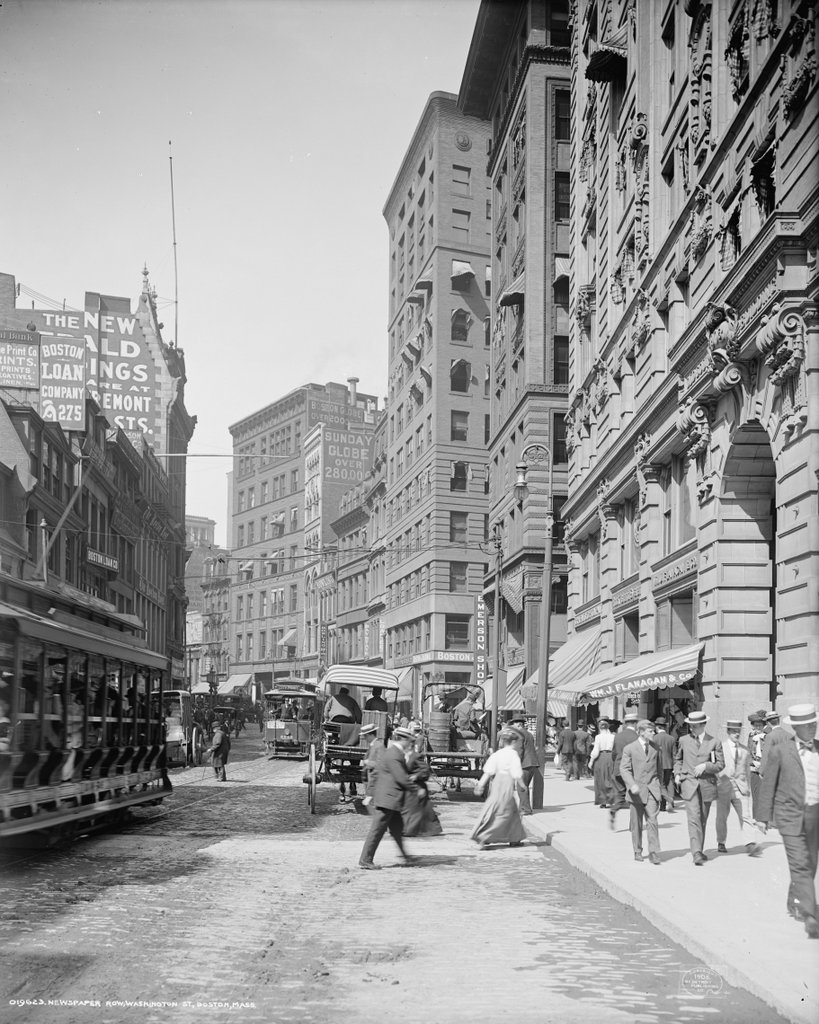
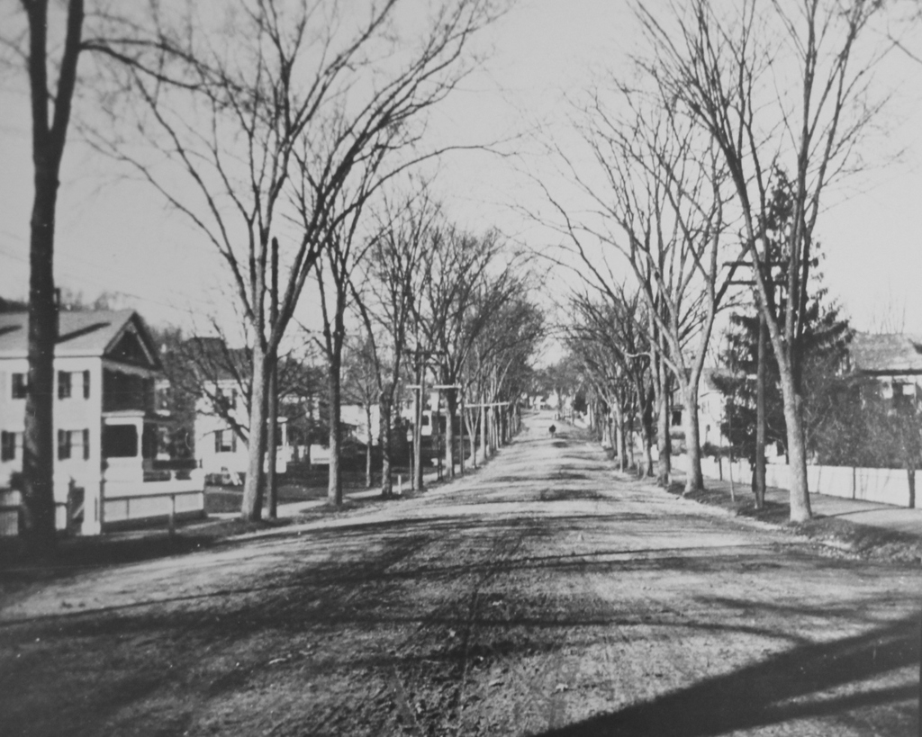
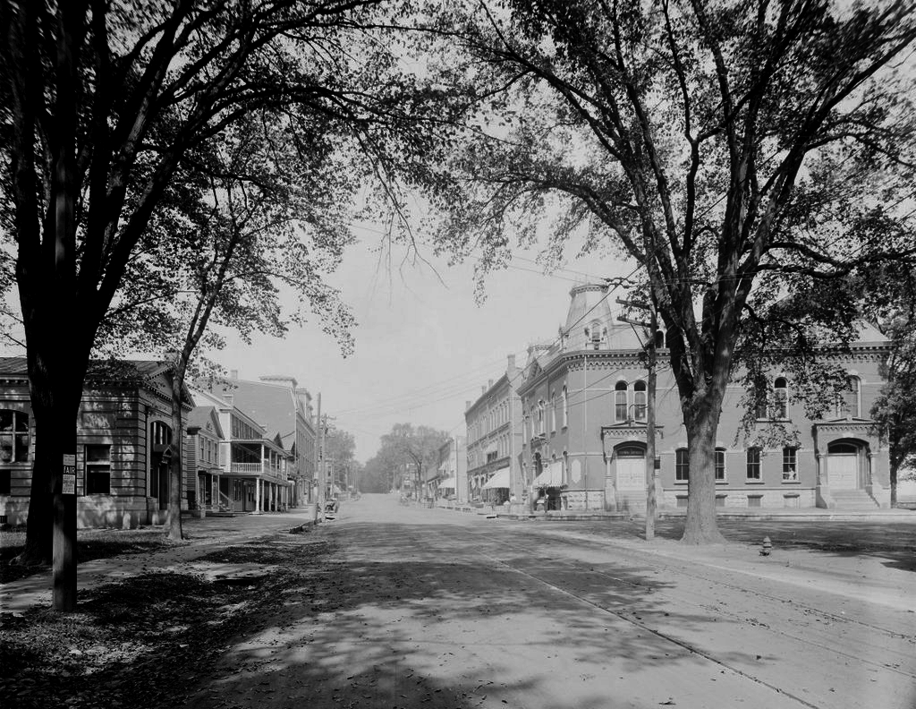
Copley Square Hotel, Boston

The Copley Square Hotel at the corner of Huntington Avenue and Exeter Street, around 1909. Image courtesy of the Library of Congress, Detroit Publishing Company Collection.

770_1909c loc
The hotel in 2015:

770_2015
Not to be confused with the nearby Copley Plaza Hotel, this historic hotel was built in 1891 and has remained here for the past 125 years.  It was originally located at the edge of a large rail yard, with the tracks coming all the way up to the west side of Exeter Street, just out of the frame to the left.  Despite the name, the hotel is actually a block away from Copley Square, but it was still a convenient location for guests.  By the time the hotel opened in 1891, Copley Square had become a major cultural center in Boston, with the Trinity Church, New Old South Church, Museum of Fine Arts, and MIT all located right around the square, and the Boston Public Library’s McKim Building under construction at the time.

In the century since the first photo was taken, this section of the Back Bay south of Boylston Street has undergone some dramatic changes.  The rail yard was replaced with the Prudential Center in the 1960s, and some of Boston’s tallest buildings are within a couple blocks of here, including the John Hancock Tower, the Prudential Tower, and 111 Huntington Avenue.  Other historic buildings, including Mechanics Hall just down Huntington Avenue from here, have been demolished, but the Copley Square Hotel is still standing as the only surviving 19th century building on Huntington Avenue between Copley Square and Massachusetts Avenue.  The building’s interior was extensively renovated in 2008, but from the outside it doesn’t look much different today than it did in 1909.

Main Street, Monson, Mass

Looking north on Main Street from near State Street in Monson, around 1890-1910. Image courtesy of the Monson Free Library.

762_1890-1910c mfl

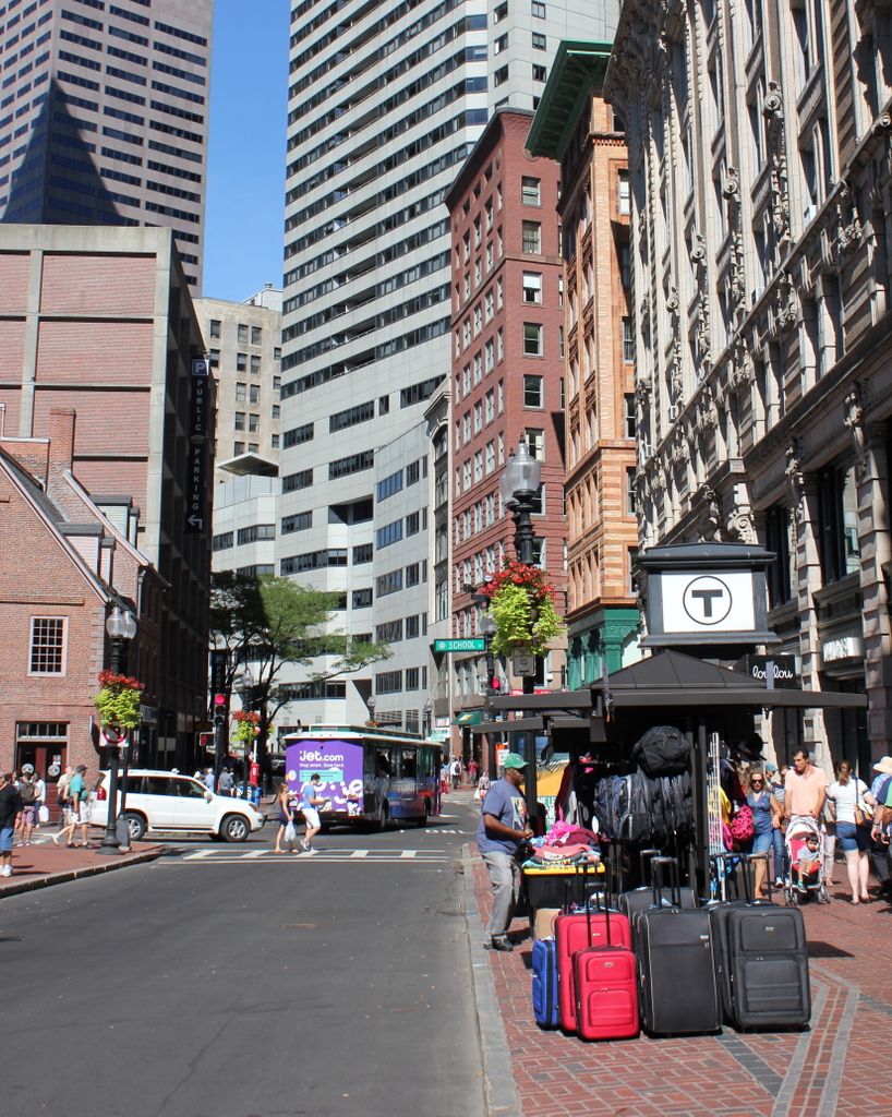
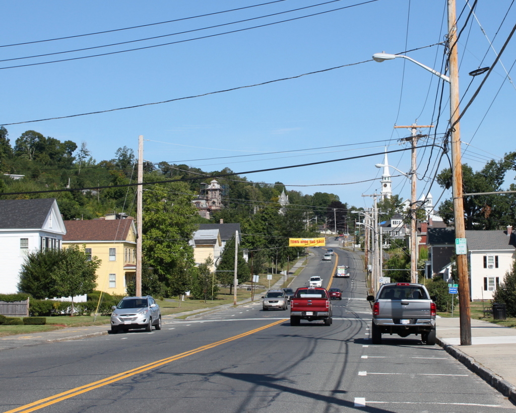
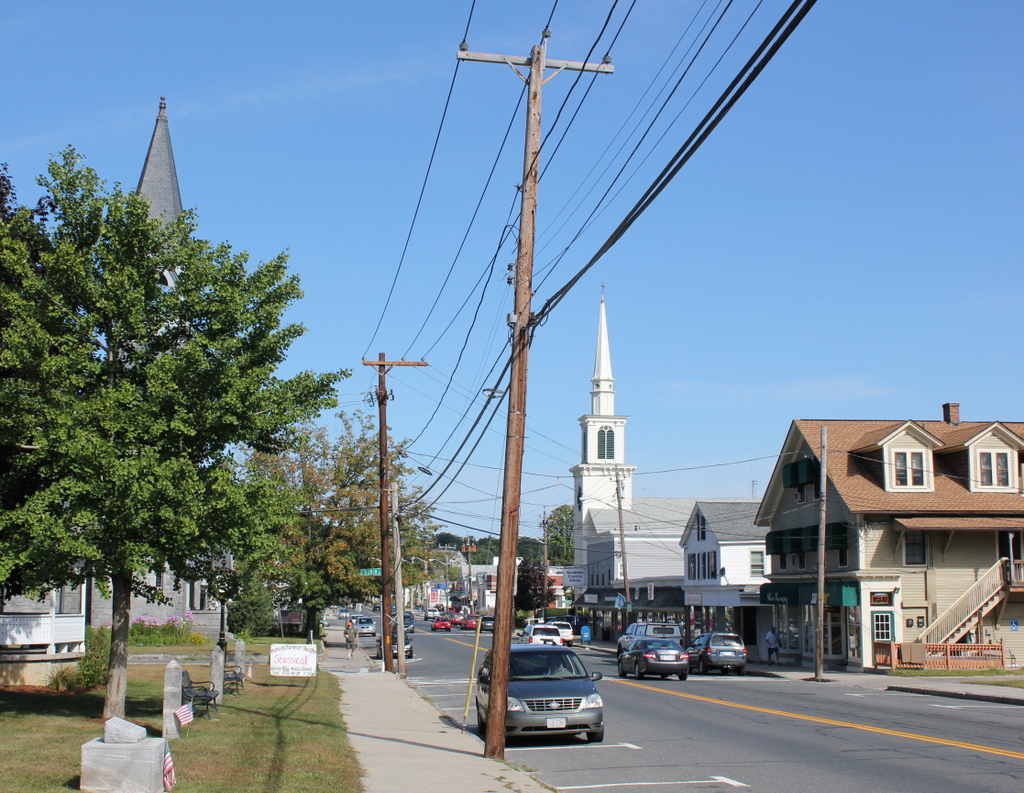
Main Street in 2015:
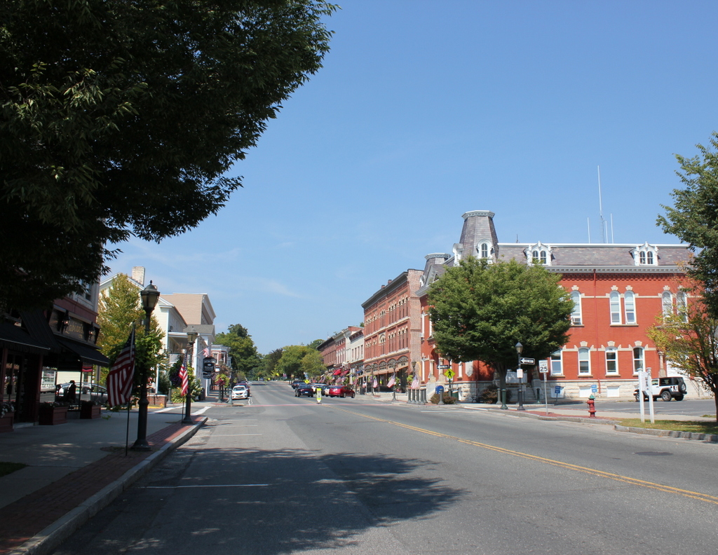
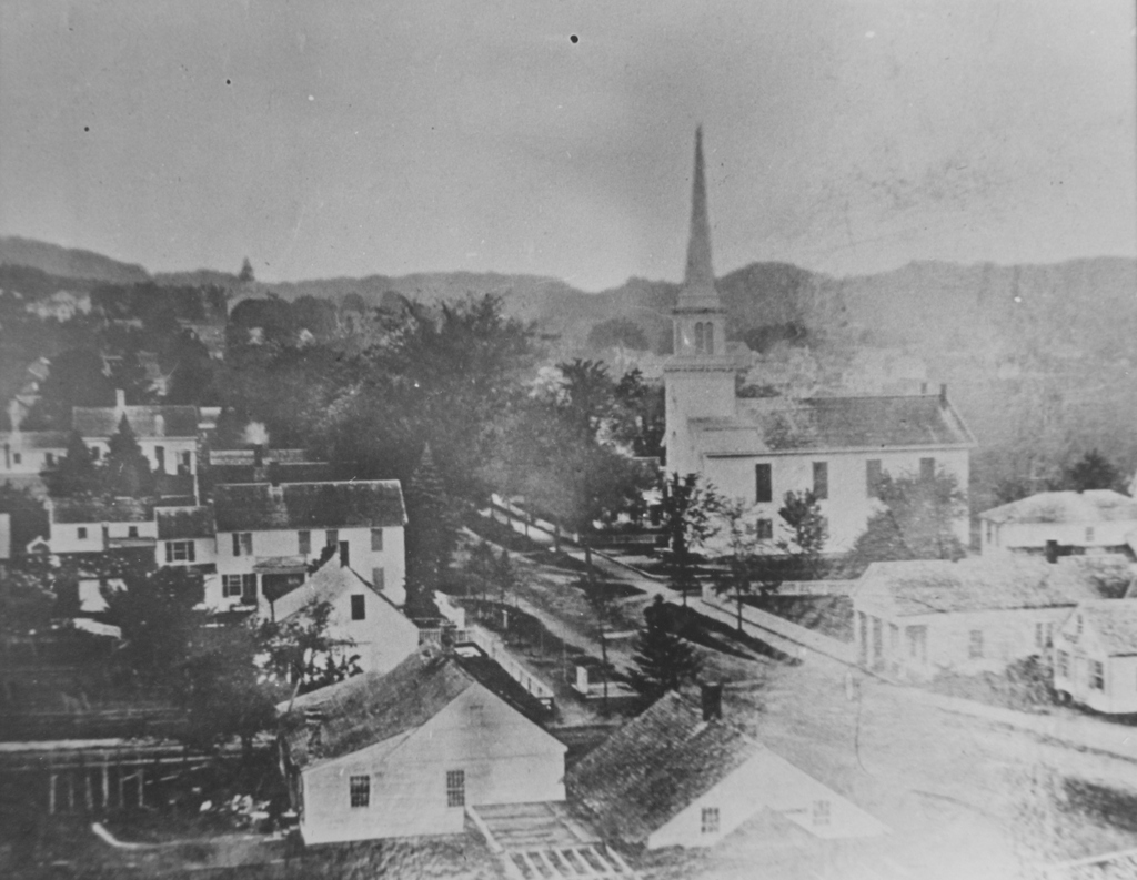
762_2015
This section of Main Street was once known as “Millionaires’ Mile,” and it featured a number of elegant 19th century homes that were owned by prominent factory owners and other businessmen in Monson.  In previous posts I highlighted two neighboring homes that belonged to the Norcross family and Cushman family, and this photo was taken just north of them, in front of Cushman Hall.

Many of the homes from the first photo are still standing today, despite over a century of change and a devastating tornado that passed directly through this scene in 2011.  The trees hide some of the houses in the first photo, but nearly all of them from the foreground to the crest of the hill are nearly identical Greek Revival homes that date back to around the 1840s.  This style was particularly popular in industrialized New England cities like Hartford, New Haven, and New Bedford, but it can also be seen here in Monson, where similar industrial growth was occurring on a smaller scale.

The two houses on the far left, which are painted white and yellow in the 2015 photo, are essentially identical, and they were both built in 1842.  The one on the left was the home of Rufus and Sarah Fay, and the yellow one to the right was the home of Charles and Mary Ann Merrick.  Aside from being family, though, the two men were also business partners; they owned a straw hat factory across the street, where the Monson Town Offices are today.  Together they, and later their children, ran Merrick & Fay for over 50 years, and the company was a major employer in the town.  Their sons sold the company in 1891, and the factory burned down in 1912, but their twin houses are still standing on Main Street.

Other wealthy 19th century residents of this section of Main Street included Edward Cushman, who lived in the house on the far right.  He left it to the town in his will, and today it is the Monson Senior Center.  Further up the hill, the Victorian mansion just to the left of center was the home of Cyrus W. Holmes, a factory owner who lived in the Victorian mansion seen on the hill just to the left of center.

In more than 100 years since the first photo was taken, Main Street has seen many changes.  A trolley line was added and later removed, the road was paved, automobiles replaced both the horse-drawn carriages and the trolleys, and the 1938 hurricane destroyed most of the elms that once lined both sides of the street.   The street is no longer filled with millionaire businessmen either, but their former homes help contribute to the character of downtown Monson and serve as a reminder of the town’s industrial history.

Downtown Monson, Mass

Looking north on Main Street in Monson from near Lincoln Street, in 1860. Image courtesy of the Monson Free Library.

759_1860 mfl

The scene in 2015:

759_2015
The first photograph is among the earliest known images of Monson, and it shows a town in transition.  Founded 100 years earlier, Monson’s development had been largely limited by geography.  The town center, seen here, is located in a narrow valley with steep hills on either side, making large-scale farming impractical and transportation difficult.  However, 10 years before the first photo was taken, a railroad was built through the town, just out of view to the left.  This helped to spur industrial development, and in the second half of the 19th century the town’s population and economy grew thanks to a granite quarry, along with factories that produced textiles and hats.

When the 1860 photo was taken, this section of Main Street was still mostly residential, but by the end of the century many of these homes would be demolished and replaced with commercial buildings, especially the older homes in the foreground.  Other late 19th century changes included several new churches.  The old meeting house, whose steeple can be seen in the distance to the left, was replaced by a larger church in 1873, and in 1889 the Universalist church was built at the corner of Main and Lincoln Streets; it can be seen to the left in the 2015 photo, partially hidden by the tree in the foreground.

Despite all of the changes over more than 150 years, there are several buildings from the first scene that are still standing today.  The most obvious is the Methodist church, which was built in 1850 at the corner of Main and Cushman Streets.  Today, aside from a new steeple, it still looks essentially the same as it did in the 1860 photo.  Further up Main Street, many early 19th century houses are still standing today, but only a couple are readily identifiable in the 1860 photo.  The fourth house on the left is now the Unitarian-Universalist church parsonage, and it is located just beyond the present-day church and out of view from here.  Beyond it on the far left is the Joel Norcross House, which had been built around 30 years earlier by Emily Dickinson’s grandfather.  It is also hidden from view in the 2015 scene, but it is still standing and has since been converted into business and office space.

Ely Road, Monson, Mass

Looking up the hill on Ely Road toward the Keep Homestead, sometime around 1900-1920. Image courtesy of the Monson Free Library.

753_1890-1920c mfl

Ely Road in 2015:

753_2015
Ely Road is named for Alfred Ely, who lived on the street and served for 60 years as the pastor of the First Church of Monson.  The church is located at the bottom of Ely Road about a quarter mile from here, and from 1809 until 1843 Ely lived at the house at the top of the hill.  The house was built around 1800, and in 1854 it was purchased by Marcus Colton, who conveyed it to his nephew Edward Keep two years later.  From then it would remain in the Keep family for the next 132 years, until the death of Edward Keep’s granddaughter, Myra Keep Lovell Moulton, in 1988.

Upon her death, Myra willed the house to the town, to be used as the Keep Homestead Museum.  The house is hidden from view by the trees in the 2015 photo, but it is still there, and it is open to the public once a month from April to December.  Its collections include Myra’s extensive button collection, along with other antique furnishings, documents, and other items relating to the history of Monson.

153-157 Boston Road, Springfield, Mass

A commercial block on Boston Road in Springfield’s Pine Point neighborhood, around 1938-1939. Image courtesy of the Springfield Preservation Trust.

746_1938-1939 spt

The building in 2015:

746_2015
Springfield’s Pine Point neighborhood was developed in the early 1900s, and consisted primarily of middle class, single-family homes.  This section of Boston Road was the commercial center of the neighborhood, and the first photo shows a variety of businesses here, including two grocery stores, a dry goods store, and a dry cleaners.  Just out of view to the left was the first Friendly’s restaurant, which opened a few years before the photo was taken.  These buildings were probably built around the 1920s or 1930s, and although the stores have changed, the buildings themselves are still standing.

Collins Inn, Wilbraham, Mass

Collins Inn at the corner of Boston Road and Chapel Street in North Wilbraham, probably in the 1890s or early 1900s.  Image courtesy of the Wilbraham Public Library.

742_1800sc wpl

The scene in 2015:

742_2015
The historic center of the town of Wilbraham has always been along Main Street in the town’s approximate geographic center.  When it was first settled in the 1700s, this was the ideal place for farming, but as changes in industrialization, transportation, and communication came about in the 1800s, the village of North Wilbraham gained prominence.  Its location on the banks of the Chicopee River and along the main road from Springfield to Boston made this area an important spot for industry and transportation.  In 1839, the Boston & Albany Railroad opened through here, with the North Wilbraham railroad station being located right across the street from here.

The building in the foreground of the first photo was the Collins Inn, which was opened in 1874 by Warren L. Collins.  It sat directly across Boston Road from the railroad station, and across Chapel Street from the Hollister Block, which at the time was used as a drugstore and post office.  In addition to the inn, Collins also operated a livery stable on the site, and ran a stagecoach line from here to the center of Wilbraham, about two miles away.

Aside from transportation, though, the Collins inn also offered Wilbraham another connection to the outside world – the telephone.  The telephone was invented in 1876, and within just four years a line was established from here to the center Wilbraham, at a cost of $30 per year for subscribers.  However, a few years later the cost increased to $100 per year (equivalent to over $2,400 today), and the service was discontinued because of a lack of families willing to pay.  When phone service was re-established in 1904, the Collins Inn became the town’s telephone exchange office for the New England Telephone and Telegraph Company, serving 21 customers in Wilbraham.

The telephone exchange remained here until 1914, when it moved to a different building across the street.  Around the same time, the Collins Inn closed, although the building itself remained standing for some time.  The 1964 History of Wilbraham book indicates that it was still standing at the time, although today its former location is now a parking lot.